Koča pri Savici - Triglav (via Triglavska jezera)
Starting point: Koča pri Savici (653 m)
| Latitude/Longitude: | 46,28960°N 13,80220°E |
| |
Route name: via Triglavska jezera
Walking time: 8 h 55 min
Difficulty: very difficult marked way
Elevation gain: 2211 m
Elevation difference along the route: 2530 m
Map: Triglav 1:25.000
Recommended equipment (summer): helmet, self belay set
Recommended equipment (winter): helmet, self belay set, ice axe, crampons
Views: 176.694
 | 15 people like this post |
Access to starting point:
From the Ljubljana - Jesenice motorway, take the Lesce exit and follow the road towards Bled and further towards Bohinjska Bistrica. Continue driving towards Lake Bohinj (Ribčev Laz), where you come to a junction and continue straight ahead on the left (southern) side of the lake in the direction of Ukanc and the Savica waterfall. Follow this increasingly narrow road to the large parking lot at Koča pri Savici. The parking lot is paid.
Route description:
From the parking lot, we head right in the direction of Črno jezero, Koča pri Triglavskih jezerih and Hotel Zlatorog (straight ahead Slap Savica and Dom na Komni). The path initially leads us along a macadam road that crosses the Savica river over a bridge. Just a little beyond the bridge, signs for Komarča direct us left (straight ahead Hotel Zlatorog) onto an initially still quite wide and relatively gentle forest path. The path soon starts to climb more steeply and a bit higher brings us to the place where the path to the source of Savica and the Velika Savica cave branches off to the left, while we continue right along the increasingly steep path.
The well-maintained and relatively wide mountain path soon passes onto very steep and slippery slopes of Komarča, where there is also a high risk of falling rocks. The path ahead climbs steeply along the mostly forested wall of Komarča, where fixed ropes, mainly steel cables, help us on more difficult sections.
Higher up, some views open from the path towards Bohinj, and the path brings us to a short technically demanding section, where with the help of rungs and a steel cable we cross a not very exposed gully. The path ahead still climbs steeply for some time and with the help of some protections brings us to the edge of Komarča, from where a nice view opens to our starting point. A short moderately steep ascent follows, then the path starts to gently descend towards Črno jezero, which we reach in less than five minutes of further walking.
Near the lake, there is a marked junction, where the path to Planina Viševnik and Pršivec branches off to the right, while we continue slightly left and continue the path along the marked trail that bypasses Črno jezero on the right side. On the other side of the lake, the path from Dom na Komni joins from the left, and we continue along a relatively gentle path that continues along the edge of Lopučniška dolina. Higher up, the path starts to moderately ascend and along the edge of overhanging cliffs brings us to a small spring, which dries up in dry periods.
We continue along the marked path, which near Bela skala turns sharply right and climbs steeply. A few minutes of steep ascent follow, then the path flattens and brings us to a marked junction, where the path from Planina Blato joins from the right, namely the path over Prode. We continue left in the direction of Koča pri Triglavskih jezerih and continue the path along a relatively gentle path, along which we arrive at Dvojno jezero in ten minutes of further walking. The marked path bypasses the lake on the right side and before we reach the other side brings us to a junction, where the path to Štapce and Mala Tičarica branches off to the right.
Here we continue straight and in a few minutes of further walking arrive at Koča pri Triglavskih jezerih.
From the hut, we continue in the direction of Triglav, Dolič, Hribarice, Prehodavci and Veliko Špičje, where the path first leads us past the dam and the artificial lake Močivec. The path bypasses the lake on the right, eastern side and in continuation moderately ascends through the Valley of the Triglav Lakes, which is overgrown with increasingly sparse forest.
Still in the belt of sparse forest, the path forks, and we continue along the slightly right path that continues towards Prehodavci and Hribarice (left path to Veliko or Lepo Špičje over the plateau Zgornje Komne) and leads us initially still through sparse larch forest, then below the screes of the mighty Kopica and later Mala Zelnarica. Later, the path temporarily climbs a bit more and brings us to a small pass, from which a nice view opens to Jezero v Ledvicah.
The marked path bypasses the mentioned lake on the right side, where it continues over extensive screes at the foot of both Zelnarice. Behind the lake, the path returns from the screes to the Valley of the Triglav Lakes, along which we continue a relatively gentle ascent. Already a completely high-mountain path, higher up it climbs more steeply for a short time, then flattens completely and after a few minutes of further walking brings us to Zeleno jezero.
At Zeleno jezero, we continue right in the direction of Triglav, Dolič and Hribarice (straight Rjavo jezero and Prehodavci) and start ascending towards the screes under Poprovec, where the path from Prehodavci joins from the left, which leads past Rjavo jezero, while we continue right in the direction towards Hribarice.
A transverse ascent over the scree to the right follows, when we reach the valley under Hribarice we join the path that leads over the Vrata pass (path along the valley Za Kopico, or path along the ridge of Zelnarice).
We continue left towards Triglav, Dolič, Kanjavec and Hribarice (right Vrata pass) and start ascending towards the Hribarice plateau. At the beginning of the Hribarice plateau, the first path to Kanjavec branches off to the left, a bit higher, at the Hribarice saddle, the second one.
From both junctions, we continue straight and follow the signs for Koča na Doliču, behind the Hribarice saddle we start descending over screes between Kanjavec on the left and Mišeljski konec on the right. Lower down, we leave the area of extensive screes and in a few minutes of further walking arrive at the Dolič saddle, where there is a marked junction.
Here we go left in the direction of Koča na Doliču (sharp right Vodnikov dom na Velem polju, right Dom Planika pod Triglavom) to which we arrive in a few minutes of gentle descent.
At the hut, there is a junction, we choose the right path, along which there are signs for Triglav (left Kanjavec, straight Zadnjica and Luknja), a little further the path from Zadnjica joins, which bypasses Koča na Doliču.
Here too we go right, the path continues for some time along a mule track that leads us north and climbs quite steeply. Higher up, the path flattens and brings us to Sedlo (2305 m), where it turns slightly left.
A few easy walking follows with a beautiful view of Triglav and the surrounding mountains, but we must be careful due to the high-mountain karst world, so that we do not fall into some hole, or injure our legs on the jagged karst surface.
The path ahead starts ascending again, to the left an unmarked path branches off to the Triglavska vojašnica Viktorja Emanuela III. (sometimes incorrectly called Morbegna), while we in continuation bypass Glava v Zaplanji on the right eastern side, behind which we join the path that leads over Plemenice.
We head right towards Triglav and ascend over the scree to the start of the climbing part of the path, where we transversely ascend along a well-secured path on an exposed wall. Such a path brings us below the Triglavska or Bovška škrbina, then we steeply ascend to the mentioned notch, where the Gorjanska path from Planika joins us.
We continue left upwards towards Triglav (straight down Planika) along a steep but well-secured path. After a few minutes of further ascent, the steepness eases and only a few minutes of walking along the summit slope of Triglav await us to the top.
Starting point - edge of Komarča 1:35, edge of Komarča - Črno jezero 0:05, Črno jezero - junction above Lopučniška dolina 1:15, junction above Lopučniška dolina - Dvojno jezero 0:10, Dvojno jezero - Koča pri Triglavskih jezerih 0:05, Koča pri Triglavskih jezerih - branch for Veliko Špičje 0:25, branch for Veliko Špičje - branch to Jezero v Ledvicah 0:30, branch to Jezero v Ledvicah - Zeleno jezero 0:45, Zeleno jezero - junction under Vršaki 0:30, junction under Vršaki - saddle Hribarice 0:30, saddle Hribarice - saddle Dolič 0:30, saddle Dolič - Koča na Doliču 0:05, Koča na Doliču - Sedlo 0:30, Sedlo - junction Zaplanja 0:50, junction Zaplanja - Triglavska škrbina 0:35, Triglavska škrbina - Triglav 0:35.

Along the route: Komarča (810m), Rob Komarče (1295m), Vrh Komarče (1313m),
Črno jezero (1294m), Bela skala (1575m), Razpotje nad Lopučniško dolino (1671m), Ruski grob (1686m), Dvojno jezero (1689m),
Koča pri Triglavskih jezerih (1685m), Močivec (1690m), Odcep za Veliko Špičje (1762m), Odcep k Jezeru v Ledvicah (1854m),
Lake Jezero v Ledvicah (1831m),
Lake Zeleno jezero (1988m), Razpotje nad Rjavim jezerom (2087m), Razpotje pod Vršaki (2192m), Razpotje pod Hribaricami (2292m), Hribarice (2332m), Sedlo Hribarice (2364m), Sedlo Dolič (2165m),
Koča na Doliču (2151m), Sedlo (2305m), Razpotje Zaplanja (2512m), Triglavska škrbina (2655m)
Photos:
 1
1 2
2 3
3 4
4 5
5 6
6 7
7 8
8 9
9 10
10 11
11 12
12 13
13 14
14 15
15 16
16 17
17 18
18 19
19 20
20 21
21 22
22 23
23 24
24 25
25 26
26 27
27 28
28 29
29 30
30 31
31 32
32 33
33 34
34 35
35 36
36 37
37 38
38 39
39 40
40 41
41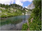 42
42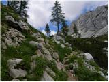 43
43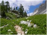 44
44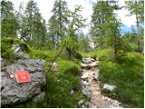 45
45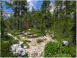 46
46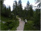 47
47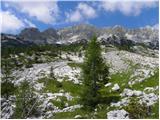 48
48 49
49 50
50 51
51 52
52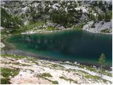 53
53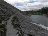 54
54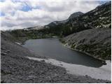 55
55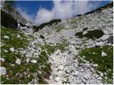 56
56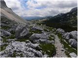 57
57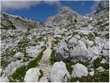 58
58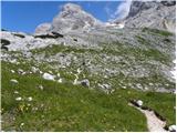 59
59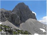 60
60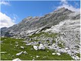 61
61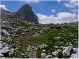 62
62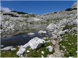 63
63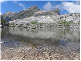 64
64 65
65 66
66 67
67 68
68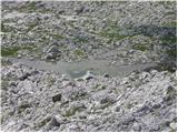 69
69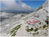 70
70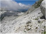 71
71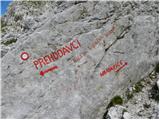 72
72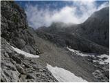 73
73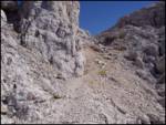 74
74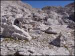 75
75 76
76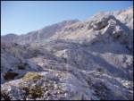 77
77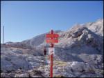 78
78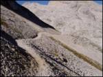 79
79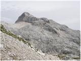 80
80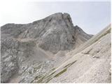 81
81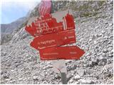 82
82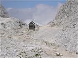 83
83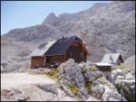 84
84 85
85 86
86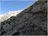 87
87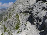 88
88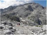 89
89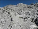 90
90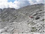 91
91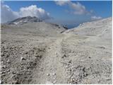 92
92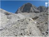 93
93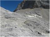 94
94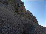 95
95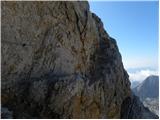 96
96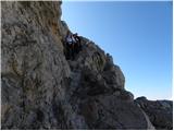 97
97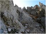 98
98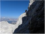 99
99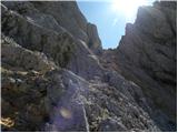 100
100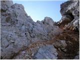 101
101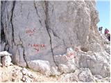 102
102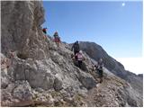 103
103 104
104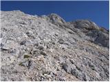 105
105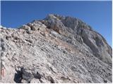 106
106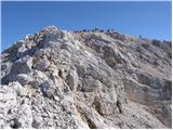 107
107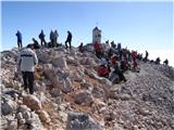 108
108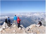 109
109
Discussion about the trip Koča pri Savici - Triglav (via Triglavska jezera)
Show older messages
|
| Gost19. 09. 2006 |
This is the real route to Triglav. First warm-up over Komarča then a walk past the lakes to Dolič and an adrenaline-packed finale! but when I was up there it was foggy but when I was up there it was foggy so I didn't see the surroundings very well. so I didn't see the surroundings very well.  Plp Janez Plp Janez
|
|
|
|
| Gost21. 11. 2006 |
Hello, this is an imposing tour. Are there maps on CD for this tour already? Greetings Konrad k_hass@arcor.de
|
|
|
|
| Gost27. 12. 2006 |
 I felt as if I were on a highway. I felt as if I were on a highway.
|
|
|
|
| Gost7. 03. 2007 |
obozevalec: nice job on the lake pictures, I've admired them many times. I've also visited this place several times myself, thanks for your effort.
|
|
|
|
| Gost2. 04. 2007 |
For an average mountaineer this is a two or three-day tour. Technically demanding spots on Komarča in dry don't pose major danger. In wet it's dangerous for slipping. Triglav summit part is a secured climbing path that average hiker handles easily. Caution still needed, one wrong step can be fatal. Safe steps. Janez
|
|
|
|
| Gost2. 04. 2007 |
Three days is really a bit too much.
|
|
|
|
| Gost12. 04. 2007 |
About nine years ago I did a similar trip, only in the opposite direction, starting at Rudno polje. From Tržaška koča to Prehodavci we went under Kanjavec. Super view of Zadnjica and towards Italy. But the path is a bit less safe on certain sections. For the path we (7 participants) took two days. This year I'd like to repeat this trip. Does anyone perhaps know how the path under Kanjavec was last year?
|
|
|
|
| Gost5. 06. 2007 |
I needed 4 hours for the mentioned route alone!
|
|
|
|
| Gost12. 06. 2007 |
Super tour. Tons of natural beauties and not too difficult a tour. I've walked it 4 times already.
LP
|
|
|
|
| Gost25. 06. 2007 |
very super trail where you have something to see
three days is a bit touristy I did it like that
for two days it's quite a nice tour
this weekend there was still some snow
|
|
|
|
| Gost2. 09. 2007 |
Please, someone reply which is the safest path to Triglav. Thanks!  
|
|
|
|
| Gost3. 09. 2007 |
All paths to Triglav are very well secured, only via Plemenice might be a bit worse. On the path via Plemenice there are currently some damaged protections.
The easiest path is probably via Dolič or via Planika and Mali Triglav.
|
|
|
|
| Nickster22. 07. 2008 |
I don't believe "Guest" climbs up in 4 hours
|
|
|
|
| SimonS3. 08. 2009 |
Given that the Koča na Doliču - Tržaška koča is collapsed, what would be an alternative for overnight stay?
|
|
|
|
| klavdipo3. 08. 2009 |
The Koča na Doliču (its remains - old part) is provisionally supplied and it is also possible to sleep there!
|
|
|
|
| triglavski3. 08. 2009 |
Sleeping is limited to about 13-14 people, as they told me the beds are fully occupied every day, alternative is Zasavska koča na Prehodavcih or Dom Planika.
|
|
|
|
| SimonS3. 08. 2009 |
Yeah, then Planika, but the weather looks bad ;(
|
|
|
|
| SimonS4. 08. 2009 |
At Koča Savica do you pay parking?
If I arrive at 6am and the car stays there for two days, who do I pay so that nothing happens?
|
|
|
|
| Lj4. 08. 2009 |
Last year I arrived just before 7 a.m., since there was no "collector", I didn't look for him but parked. The next day in the afternoon I returned from the tour and no one asked me for the parking fee, nor did I offer.  I was quite lucky regarding costs... I was quite lucky regarding costs...
|
|
|
|
| Kriška4. 08. 2009 |
The small parking lot in front of Koča pri Savici should not be paid (!), as it belongs to the hut. The warden told me that two years ago. Last year I waited in the hut for acquaintances returning from Komna to drive them to the starting point and parked at the hut. The collector came running and wanted to charge me, but I explained that I am a guest of the hut and not of "his" parking lot and then he didn't insist anymore.
|
|
|
|
| gabi4. 08. 2009 |
Parking fee is 3 €. Last time I arrived there at 07:30 and there were still quite a few free spots.
|
|
|
|
| tomek99920. 08. 2009 |
What are the prices for overnight stays at Triglav?
|
|
|
|
| fiorelin4. 09. 2009 |
Is around 25.9. a suitable time to go to Triglav? We would start at Savica on Friday to Triglav, and back from Planika to Pokljuka we have 3 days, will it be enough?

|
|
|
|
| triglavski5. 09. 2009 |
There's always time for Triglav, even on December 19th say or January 27th, if the weather is just nice. Of course also on September 25th, unless it's raining as much as these days, then it really makes no sense.
|
|
|
|
| fiorelin6. 09. 2009 |
Yes, but since we're not some expert mountaineers. There's a bit of fear of snow. They say some has already fallen now. And we don't have crampons or similar equipment.
|
|
|
|
| triglavski6. 09. 2009 |
This snow will melt soon, on sunny sides some patches might remain where even with crampons you can't do much, ice axe is useful to make steps. Otherwise, it's often snow-free even in October, then of course there's the problem with accommodation because huts are mostly closed. But that's how it is, some don't like summer because of crowds, so they choose quieter months, then weather spoils it. But the mountain waits, so... it will for you too.
|
|
|
|
| ncnevem8. 09. 2009 |
Hello! We are planning a 3-day tour over the lakes to Triglav and since there are 2 less experienced hikers among us, we decided for a three-day tour. I would like to ask someone who has already walked this path to advise me how to divide the path by days or in which huts to overnight so that the path is proportionally distributed... thanks!
|
|
|
|
| petruša10. 02. 2010 |
I'm interested if you go via Triglav Lakes, whether you can go towards Planika or if you have to go to Dolič. Because last year we went via Dolič to Triglav with kids (9 and 10 years old), but it drags on a lot. That's why this year we would like to go via Triglav Lakes, then to Planika and sleep there. If anyone has experience, please share. Thanks
|
|
|
|
| Gorazd G10. 02. 2010 |
From the Triglav Lakes to Triglav it will be more difficult without Dolič (via Hribarice or Kanjavčeve police - less suitable for curious kids). From there you can go to Triglav where you went last year, or to Planika and from there to the summit. I warmly recommend one of the maps and guidebooks available on the market. Then many things will be clearer. Good luck!
|
|
|
|
| turbo10. 02. 2010 |
Petruša,
there is another option, but the path lengthens considerably. From Triglav Lakes you can go to Koča na Planini pri Jezeru, from there to Vodnikov dom and onwards to Planika. From there to Triglav. The mentioned path, although long, is very nice, suitable for children, but indeed you need to take one or two more days.
Gorazd G wrote best: map and guidebook in hand, there are really many nice paths or connections between huts in that area. Best regards
|
|
|
|
| joža x13. 02. 2010 |
From the valley of 7 lakes you can go to Dolič or Planika then to the summit, but to Planika it's longer than to Dolič, but the ascent to the summit from Planika is shorter than from Dolič. A circular tour is probably the best.
|
|
|
|
| oakley_sf7. 11. 2010 |
for next year I have this tour planned! I can hardly wait for summer
|
|
|
|
| bobby6. 07. 2012 |
Hello. I'm interested in the following. They say of course that going down is faster than up. I assume fitness is not an obstacle, that time is the only obstacle. If I start say at 5 am via Tominšek or through Prag and I'm at the top around 11:30 with a short stop at Kredarica. It says from Koča pri Savici past the lakes 8h 45min uphill. How much time can I count for the descent at a normal pace without rushing. Is this feasible in 1 day in your opinion?
|
|
|
|
| Petra887. 07. 2012 |
I'm thinking about the Triglav Lakes without Triglav, how much time do you think I would need? Physical fitness is medium, so do you think it can be done in one day or is it better in two?
|
|
|
|
| Zebdi7. 07. 2012 |
With some medium physical fitness, it should be doable in one day. Especially if you go from Planina Blato (more gently sloping) or via Komarča (quite steep, but personally much nicer to me).
You can find descriptions of both routes here
|
|
|
|
| matej4712. 08. 2012 |
I don't recommend this tour for one day. It doesn't make sense, better slower and enjoy the views and breaks
We took two and a half days for this tour, and it was just right. We started after work (around half six) and the first day reached the hut at Triglav Lakes (2.5 hours walk) where we slept. The next day we continued along the described path and slept at Kredarica (total 8 hours walk). From there we returned via Vodnikov dom, Malo polje, Mišeljski preval, Planina Laz, Koča na Planinskem jezeru, Viševnik, Komarča and back to Savica (total 7.5 hours walk). On the way back you have two shorter ascents, but the landscape is wonderful, especially around Planina Laz. Really nice, highly recommended!
|
|
|
|
| Petra8812. 08. 2012 |
I was today at the Koča pri Triglavskih jezerih, for the other lakes I said I'll jump sometime else (I'll take 2 days and I have to say that the landscape and the path are really beautiful. I started from planina Vogar to Viševnik, then Koča na Planinskem jezeru, Dedno polje, Koča pri Triglavskih jezerih (via Štapce) and back via Prode to planina Ovcarija, Viševnik, Koča pri Planinskem jezeru and finish at planina Blato. Recommended!
|
|
|
|
| ljubitelj gora28. 08. 2012 |
I needed 12 hours and 30 minutes for the loop Koča pri Savici - Tičarica - Velika Zelnarica - Dolič - Triglav and return via the seven lakes, a one-day tour is very strenuous and hard to accomplish, extremely fast walking, little breaks, but my wish from 3 years ago, back then I had to end prematurely.
|
|
|
|
| dekovic1. 05. 2013 |
This year I'd go to Triglav for the first time and I'm wondering if someone doesn't mind extra company and has experience to take me along, for the first time I'd do a two-day tour
:-)
|
|
|
|
| mummy30. 06. 2013 |
Hello
Has anyone walked these days via Triglav lakes to Triglav, mainly interested in how passable the path is.
|
|
|
|
| IgorZlodej30. 06. 2013 |
All paths are nicely passable, from Dolič and via Gorjanska to the top it's good to have crampons and ice axe, otherwise it might not be passable
|
|
|
|
| dekovic15. 08. 2013 |
hi
this year I'd like to go to Triglav for the first time and I'm wondering if anyone is going and if I can join thanks
|
|
|
|
| AQUARO6. 09. 2013 |
Does anyone happen to have data on how many km you hike if you start at Koča pri Savici and end at Triglav? (via Triglavska jezera, Hribarice and via Dolič)
|
|
|
|
| Keko6. 09. 2013 |
Somewhere around 18 to 20 km.
|
|
|
|
| simonmanutd8. 09. 2013 |
Very nice path...demanding...and definitely do not recommend it for one day.
With Endomondo I measured from Koča pri Savici to the top of Triglav 20.5 km and 8:35 h.
Really very nice path.
My friends and I walked a total of 17 hours. We went Koča pri Savici-Komarčevo-Koča pri Sedmerih jezerih-Dolič-Škrbina-Triglav-Kredarica-Vodnikov dom destination Rudno polje.
|
|
|
|
| simonmanutd18. 09. 2013 |
I'm wondering which trip here describes the route to Triglav via the north face. Thanks
|
|
|
|
| jedriličar18. 09. 2013 |
You have two variants: via Prag or via Tominškova, both go to Kredarica and then up, check under Triglav ...
|
|
|
|
| JusAvgustin18. 09. 2013 |
But I'm sure that's exactly what he meant. I don't believe anyone would describe the Face as a hike... From the path via Prag to the right there's no more path, just pathless terrain
|
|
|
|
| IgorZlodej18. 09. 2013 |
Juš, you're mistaken, there is another path
|
|
|
|
| JusAvgustin18. 09. 2013 |
okay, far right, already over Juga's pillar...
|
|
|
|
| pikica118. 09. 2013 |
I agree Juš, that @jedriličar rightly called him out, it would also be good if he knows what the North Triglav Face is. That's why I wrote, if he happens to want to read.
I like pathless terrain
|
|
|
|
| jedriličar18. 09. 2013 |
It seems to me that simon asked for paths, not climbing routes , but I agree that the paths via prag and tominškova are not hikes ...
|
|
|
|
| dolenjka&primorc18. 09. 2013 |
Real climbing is on pathless terrain. Here (via Prag and Tominškova) it's a well protected (hooks, bolts, cables), otherwise very demanding marked path... good luck
|
|
|
|
| JusAvgustin18. 09. 2013 |
No Simon, it's not real climbing. If you don't know what ZPP is then you have no business to the right of the path via Prag.
|
|
|
|
| simonmanutd18. 09. 2013 |
oh boy....
I'm new to this... I can google and check.
Everyone just scares... no one gives a nice answer.
Except dolejnkainprimorc.
|
|
|
|
| Helena416. 08. 2017 |
We went from Triglav back via Triglav Lakes. The down path via Komarča is demanding, you have to watch every step. Not a climbing path. It's very important to go slowly as stones can easily fall on other hikers.
|
|
|
|
| lexani899. 08. 2020 |
Really nice path, I used it for the descent from Triglav. In terms of difficulty, I think the easiest route to the summit, but it's long, took approximately 9 hours downhill. At the top of Hribaric possibly some markings are missing here and there, passing hikers were wandering confused and asking for the direction. I join the opinion of others.. through Komarča a bit more carefully, especially when you already have heavy legs at the end. I think this part was also newly arranged - cleared trees and renewed markings.
|
|
|
To post a comment you must log in:
If you do not yet have a username, you must first
register.