Koča pri Savici - Veliko Špičje
Starting point: Koča pri Savici (653 m)
| Latitude/Longitude: | 46,28960°N 13,80220°E |
| |
Walking time: 5 h 40 min
Difficulty: difficult marked way
Elevation gain: 1745 m
Elevation difference along the route: 1785 m
Map: Triglav 1:25.000
Recommended equipment (summer): helmet, self belay set
Recommended equipment (winter): helmet, self belay set, ice axe, crampons
Views: 38.533
 | 5 people like this post |
Access to starting point:
From the Ljubljana - Jesenice motorway, take the Lesce exit and follow the road towards Bled and further towards Bohinjska Bistrica. Continue driving towards Lake Bohinj (Ribčev laz), where you arrive at a crossroads, continuing straight along the left (southern) side of the lake in the direction of Ukanc and Savica Waterfall. Follow this increasingly narrow road to the large parking lot at the Savica hut. The parking lot is paid.
Route description:
From the parking lot, head right towards Black Lake, Koča pri Triglavskih jezerih, and Hotel Zlatorog (straight to Savica Waterfall and Dom na Komni). The path initially leads along a gravel road that crosses the Savica River over a bridge. Just after the bridge, the signs for Komarča direct us left (straight to Hotel Zlatorog) onto a path that is initially still quite wide and relatively gentle through the forest. The path soon begins to ascend more steeply and brings us a bit higher to a spot where the path to the source of the Savica and Velika Savica cave branches off to the left, while we continue right along the increasingly steep path.
The well-maintained and relatively wide mountain path soon transitions to very steep and slippery slopes of Komarča, where there is also a high risk of falling rocks. The path ahead ascends steeply through the mostly forested wall of Komarča, where safety equipment, mainly cables, assists us on the more difficult sections.
Higher up, some views towards Bohinj open from the path, and the path brings us to a short technically demanding section, where with the help of pegs and a cable we cross a gully that is not particularly exposed. The path continues to ascend steeply for a while longer and, with the aid of some safety gear, brings us to the edge of Komarča, from where a nice view opens to our starting point. A short moderately steep ascent follows, after which the path begins to descend gently towards Black Lake, which we reach after less than five minutes of further walking.
Near the lake, there is a marked junction where the path towards Planina Viševnik and Pršivec branches off to the right, while we continue slightly left and proceed along the marked path that bypasses Black Lake on the right side. On the other side of the lake, the path from Dom na Komni joins from the left, while we continue along a relatively gentle path that runs along the edge of Lopučniška dolina. Higher up, the path begins to ascend moderately and brings us along the edge of overhanging cliffs to a small spring, which however dries up during dry periods.
Continue along the marked path, which near Bela skala turns sharply right and ascends steeply. A few minutes of steep ascent follow, after which the path levels out and brings us to a marked junction, where the path from Planina Blato, specifically via Prode, joins from the right. Continue left towards Koča pri Triglavskih jezerih and proceed along a relatively gentle path, after which in ten minutes of further walking we arrive at Double Lake. The marked path bypasses the lake on the right side and brings us to a junction even before we reach the other side, where the path towards Štapce and Mala Tičarica branches off to the right.
Here, continue straight and in a few minutes of further walking arrive at Koča pri Triglavskih jezerih.
From the hut, continue in the direction of Triglav, Dolič, Hribarice, Prehodavci, and Veliko Špičje, where the path first leads past the dam and artificial lake Močivec. The path bypasses the lake on the right, eastern side and then moderately ascends through the Valley of Triglav Lakes, which is overgrown with increasingly sparse forest.
Still in the belt of sparse forest, the path forks, and we continue on the left path towards Veliko Špičje (straight to Zasavska koča na Prehodavcih, Hribarice).
The marked Stanko Kos path towards Veliko Špičje then gradually leaves the Valley of Triglav Lakes and initially ascends only gently, for some time still through sparse forest. The path later crosses a belt of dwarf pines and then begins to ascend more steeply. Higher up, the path transitions to steep grassy slopes of Veliko Špičje, which are particularly dangerous for slipping when wet. The path, from which increasingly beautiful views open up, gradually becomes technically demanding. With the help of cables, we ascend a rocky step higher, after which it brings us to the main ridge of Špičje.
Here, continue left (right to Zasavska koča) along the path that brings us to the summit of Veliko Špičje after a few more minutes.
Starting point - edge of Komarča 1:35, edge of Komarča - Black Lake 0:05, Black Lake - junction above Lopučniška dolina 1:15, junction above Lopučniška dolina - Double Lake 0:10, Double Lake - Koča pri Triglavskih jezerih 0:05, Koča pri Triglavskih jezerih - branch for Veliko Špičje 0:25, branch for Veliko Špičje - Veliko Špičje 2:05.

Along the route: Komarča (810m), Rob Komarče (1295m), Vrh Komarče (1313m),
Črno jezero (1294m), Bela skala (1575m), Razpotje nad Lopučniško dolino (1671m), Ruski grob (1686m), Dvojno jezero (1689m),
Koča pri Triglavskih jezerih (1685m), Močivec (1690m), Odcep za Veliko Špičje (1762m)
Photos:
 1
1 2
2 3
3 4
4 5
5 6
6 7
7 8
8 9
9 10
10 11
11 12
12 13
13 14
14 15
15 16
16 17
17 18
18 19
19 20
20 21
21 22
22 23
23 24
24 25
25 26
26 27
27 28
28 29
29 30
30 31
31 32
32 33
33 34
34 35
35 36
36 37
37 38
38 39
39 40
40 41
41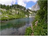 42
42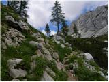 43
43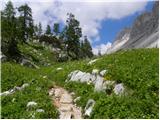 44
44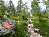 45
45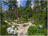 46
46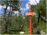 47
47 48
48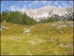 49
49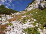 50
50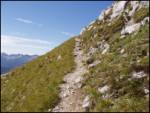 51
51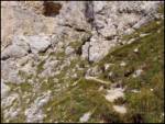 52
52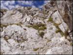 53
53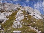 54
54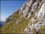 55
55 56
56
Discussion about the trip Koča pri Savici - Veliko Špičje
|
| peterhaf18. 02. 2009 |
I have a question. Is the path too difficult to take my dog with me (he's used to mountains)? Of course I would go to Koča pri Triglavskih via Komna.
|
|
|
|
| Lj18. 02. 2009 |
In my opinion there is too much rock climbing on this trail for the dog to enjoy, even though used to mountains. This would be more like torturing the dog, for him the lower trail Triglavska jezera - Prehodavci is suitable.
|
|
|
|
| aleš431. 11. 2009 |
No, no.
Too demanding trail for just any mountaineer. Let alone a dog!
Only well physically prepared mountaineers reach the summit from Koča pri Savici in 5:30. I needed 6:00 to nmv 2250 m, I needed 6:00 to nmv 2250 m, then I had to turn back due to time (timing) via Komarčna to the valley to the car! 11 hours with breaks! I returned in pitch darkness! The day is simply too short! then I had to turn back due to time (timing) via Komarčna to the valley to the car! 11 hours with breaks! I returned in pitch darkness! The day is simply too short! Huge energy goes already to Koča pri Triglavskih jezerih 3:00 hours. Komarčna takes its toll! Huge energy goes already to Koča pri Triglavskih jezerih 3:00 hours. Komarčna takes its toll! 
But it's an interesting tour in good weather, there's something to see, wonderful.
|
|
|
|
| JožiG1. 07. 2016 |
I wasn't in good physical shape, but I still made it to the top. Coming down was difficult though, as we returned via a longer route to Prehodavce and the hike was very long. 12.5 hours with breaks is very tough for someone who has only been to Velika planina this year so far . .
It's a very nice hike, but I recommend everyone to do some easier hikes first and build up fitness.
|
|
|
|
| Hribovc919. 10. 2022 22:55:58 |
Beautiful (especially in autumn), little visited (from Triglav Lakes onwards) and at the same time long path. Definitely recommend counting 6 hours for the ascent time.
|
|
|
To post a comment you must log in:
If you do not yet have a username, you must first
register.