Koschach - Fallbach (Fallbach Klettersteig)
Starting point: Koschach (850 m)
Route name: Fallbach Klettersteig
Walking time: 2 h
Difficulty: extremely difficult marked way
Via ferrata: E
Elevation gain: 300 m
Elevation difference along the route: 200 m
Map:
Recommended equipment (summer): helmet, self belay set
Recommended equipment (winter):
Views: 10.875
 | 3 people like this post |
Access to starting point:
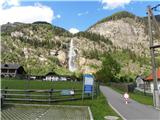
Through the Karawanks Tunnel, we drive into Austria, past Beljak to Spittal an der Drau, where we turn right towards Katschberg/Gmünd. At Gmünd we exit the motorway and drive through the village of Malta to Koschach, where a sign for „Fallbach wasserfall” directs us right to the parking lot.
Route description:
From the parking lot, we head towards the waterfall, at the ticket office we pay the entrance fee (4€), we continue towards the sports ground and on the right side look for the sign for "Fallbach klettersteig", which over logs crosses the stream (the sign is poorly visible). The path turns left up the meadow and soon we reach the first steel cables.
The beginning is easy, the path crosses along a narrow trail, then we reach the first vertical section (C/D). The path becomes even more demanding and ascends vertically (D), some pegs help us. On this part it is more about free climbing, since with the thin and loose steel cable we cannot help ourselves much.
For a short time the path levels out, then the difficulties start again. First we forcibly traverse the smooth wall (C), then ascend vertically (D). Follows a slightly less demanding traverse over the bulging rock (B/C). After a steep ascent with loose steel cable (D) we reach the hanging bridge on the left side, to the right the path branches off towards the panoramic platform, where there is also the emergency exit. Anyone who had difficulties up to this part of the path should rather return via this path, because the most difficult part follows.
Over the hanging bridge the path leads diagonally upwards over the smooth wall (D), follows a traverse (C) and we are already at the summit register box, where there is also a suitable spot for a rest before the most difficult part. The path first ascends diagonally along the ledge (D), then we reach a several-metre-high overhang (E). The inclination is approximately 25 degrees outwards, there are no holds, we ascend only by "pulling" on the steel cable, where arm strength plays the main role. At the top then follows a traverse to the left (C), vertical ascent (D), then a less demanding part of the path to the top (shorter section D, rest B/C). Since the rock is already quite worn, one must still be careful on this part.
From the top we descend via the right path, which brings us to the road in the valley after approximately 20 minutes.

Photos:
 1
1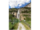 2
2 3
3 4
4 5
5 6
6 7
7 8
8 9
9 10
10 11
11 12
12 13
13 14
14 15
15 16
16 17
17 18
18 19
19 20
20 21
21 22
22 23
23 24
24 25
25 26
26 27
27 28
28 29
29 30
30 31
31 32
32 33
33 34
34 35
35 36
36 37
37 38
38
Discussion about the trip Koschach - Fallbach (Fallbach Klettersteig)
|
| Kita30. 05. 2013 |
Beautiful scenery and on some sections a demanding path, I can hardly wait for the weather to improve a bit this year and to climb it...
|
|
|
|
| slavi090230. 05. 2013 |
If I see correctly, they have installed new stronger fixed ropes, so we don't need to use those old loose ones, and regarding the weather I completely agree with you Kita
|
|
|
|
| Kita10. 06. 2013 |
At 5:00 start from Celje and first Luft unter die Schollen klettersteig D/E, then to Fallbach klettersteig E at 12:50 on top of Fallbach then to Hochalmstraße on the famous mountain road and of course coffee... The weather served us with my friend, so another unforgettable day.....
|
|
|
|
| Kita10. 06. 2013 |
A couple of grammatical errors in the above paragraph... no hard feelings....
|
|
|
|
| VanSims10. 06. 2013 |
@slavi0902: If I correctly understand this type of protection, you use both slack and taut steel cables and the question of whether some are older or newer than others. We clip into the slack ones, for the taut ones we hold on or pull ourselves along them.  This is one of the rare vias ferratas with this system and can be an exemplary case of good protection. This is one of the rare vias ferratas with this system and can be an exemplary case of good protection.
|
|
|
|
| slavi090210. 06. 2013 |
@VanSims.... thanks for the explanation, sorry for my ignorance, I promise I'll improve
|
|
|
|
| Kita3. 12. 2013 |
That's how it was this year...A couple of pictures...
|
|
|
|
| Kita3. 12. 2013 |
I couldn't manage to upload it...
|
|
|
|
| Laščan4. 12. 2013 |
You can't upload pictures here, it will only work on "Forum-razmere"!
|
|
|
|
| Matic259. 12. 2014 |
This is already too much for me. You have to know how to climb! If you knew that, you'd rather climb with a rope and belays. Why drag myself through chimneys.
|
|
|
To post a comment you must log in:
If you do not yet have a username, you must first
register.