Koča pod Košuto - Cjajnik / Lärchenturm
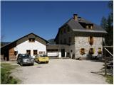
Starting point: Koča pod Košuto (1280 m)
| Latitude/Longitude: | 46,45170°N 14,38750°E |
| |
Walking time: 3 h
Difficulty: extremely difficult marked way
Via ferrata: D
Elevation gain: 685 m
Elevation difference along the route: 685 m
Map: Karavanke - osrednji del 1:50.000
Recommended equipment (summer): helmet, self belay set
Recommended equipment (winter): helmet, self belay set, ice axe, crampons
Views: 51.897
 | 4 people like this post |
Access to starting point:
Via the border crossing Ljubelj we drive to Borovlje / Ferlach, where we turn right in the direction of the village Sele / Zell-Pharre. A little before the sign which marks the settlement Sele / Zell-Pharre, the road branches off to the right towards the mountain hut Koča pod Košuto / Koschutahaus. We follow this road all the way to the mountain hut, where we park on a large parking lot.
Route description:
From the parking lot, we head towards the southeast following the signs Lärchenturm / Cjajnik, Koschutnikturm / Košutnikov turn. At the beginning of the path, we will also notice a large board with a picture of Košuta and precisely drawn paths to Cjajnik and Košutnikov turn. The path then for some time runs through the forest towards the east and brings us to a fork where we turn right following the signs Cjajnik. We soon come out of the forest to a scree field which we then cross in ascent towards the west (in the direction towards Cjajnik). When crossing the scree, we follow the red-white blazes; the big yellow blazes on the rocks should not confuse us, as they lead upwards across the scree towards the gully which leads towards the Cjajnikova škrbina notch.
At the entrance into the climbing part of the path, we must equip ourselves with a helmet and self-belay set; the use of climbing gloves is also highly recommended. The path already at the beginning steeply ascends and then crosses a steep wall to the right. The path is throughout well secured with a steel cable; occasionally some pegs also assist us, but far fewer than one might expect. There are not many footholds and much of the work during the ascent must be done with the hands. The path then for quite some time runs slightly to the right and ascends almost vertically several times. Later, the path turns to the left and ascends a somewhat easier slightly vegetated slope. For a short time the summit of Cjajnik also appears to us, then we re-enter the wall. We ascend very steeply again and the exposure also becomes greater. The steepness rarely eases in the continuation, then the path turns slightly to the right and brings us to a fork below the summit tower. We have two paths to choose from that lead to the summit; no matter which one we choose, very demanding climbing awaits us. The left path is marked with difficulty level D, the right one with difficulty level C.
Austrians assess the difficulty of climbing paths with grades from A to E, where A is the easiest and E the most difficult.
The right easier path first bypasses the summit on the right side, then ascends to the summit from the west side. The left path ascends vertically from the fork towards the summit. The climbing here is really very demanding since there are not many holds in the rock. We are assisted only by a few pegs and the vertical steel cable.
The path to Cjajnik is exceptionally demanding and suitable only for the most experienced mountaineers with sufficient arm strength and mandatory self-belaying. The path is among the most difficult in the Karawanks and harder than most Italian extremely demanding paths in the Julian Alps.
We can descend via the ascent path (in the upper part via the C difficulty level path). Another option is to descend southwards to the Cjajnikova škrbina from where we continue to the main ridge of Košuta and descend to the Slovenian side or via the climbing path to Košutnikov turn back to the starting point. The path from the Cjajnikova škrbina through the eastern gully is closed due to falling rocks.

Photos:
 1
1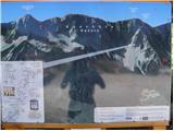 2
2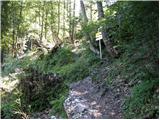 3
3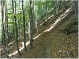 4
4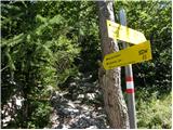 5
5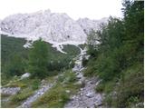 6
6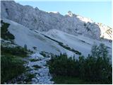 7
7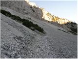 8
8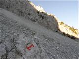 9
9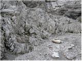 10
10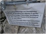 11
11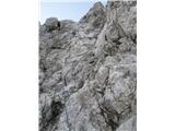 12
12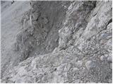 13
13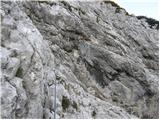 14
14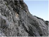 15
15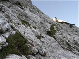 16
16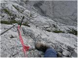 17
17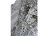 18
18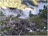 19
19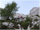 20
20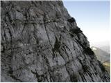 21
21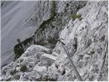 22
22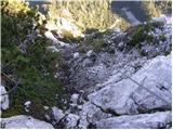 23
23 24
24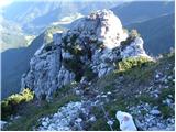 25
25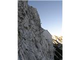 26
26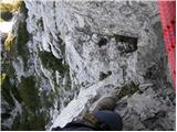 27
27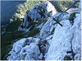 28
28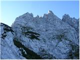 29
29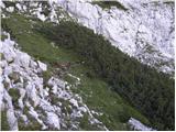 30
30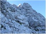 31
31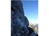 32
32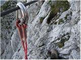 33
33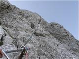 34
34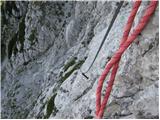 35
35 36
36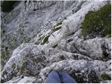 37
37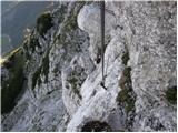 38
38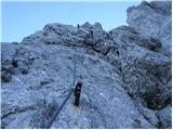 39
39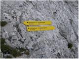 40
40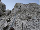 41
41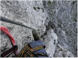 42
42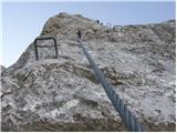 43
43 44
44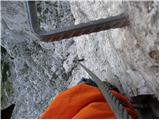 45
45 46
46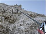 47
47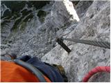 48
48 49
49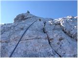 50
50 51
51
Discussion about the trip Koča pod Košuto - Cjajnik / Lärchenturm
Show older messages
|
| climBEER29. 08. 2008 |
Extremely difficult trail
|
|
|
|
| andrej jerina15. 10. 2008 |
Today Janez and I completed the ascent described above. Below the summit to the top via "D", descent via "C" variant. You can really tell there are few footholds and my height and long legs came in handy here. The trail is unique, demanding, perhaps slightly marred by the fact that more natural passages could be used for the route (but the technical difficulty would decrease). The fixed protection is in excellent condition, so all good. LP Andrej
|
|
|
|
| peterr15. 10. 2008 |
If I conclude correctly, we met Andrej and Janez at the start of the wall as they were returning. We also ascended the direct exposed variant and descended via the somewhat easier right side. Since we were a bit later, the sun and rock choughs greeted us at the summit, who immediately join for a snack. Really nice autumn tour but requires concentration and consistent protection throughout the route. The colorful scenery with golden yellow larches standing out is the icing on the cake.
Ps. Koča pod Košuto closes its doors on 26.10. and is closed until May, as the friendly caretaker told us, where we strengthened ourselves on the way back.
Peter Rožič
|
|
|
|
| skrajnik14. 07. 2009 |
Yesterday the 13th we were up there.
The path as already said is demanding, safety gear 100%.. enjoyment 100% 
|
|
|
|
| skrajnik15. 07. 2009 |
Well, philosophically speaking I don't like too much "forced" paths/feratas through walls (which is common abroad), but since it's there, we went to check it out and since I doubt I could experience something like that on my own, we of course enjoyed the dizzying views and being pulled by the cable through the "bare" wall..
Besides, our mountains are also quite drilled (besides feratas and paths I mean) so they just pull the cable and we're there..
ps: much nicer/picturesque are Slovenian paths/feratas (because they at least try to use natural passages and "aids" to the top..)
|
|
|
|
| Bojan_A22. 06. 2010 |
Has anyone been walking here recently? Is there by chance still some snowfield under the wall?
|
|
|
|
| Zenfinio22. 06. 2010 |
Bojan I was there 14 days ago and there is about 10 meters of snowfield under the wall but you can go around it without problems......
|
|
|
|
| Bojan_A23. 06. 2010 |
Aha thanks. Then ice axe no longer needed?
|
|
|
|
| maremw5. 07. 2010 |
yesterday ten of us went up. an excellent tour, worth all respect, plenty of enjoyment
|
|
|
|
| Silence5. 07. 2010 |
we went on Saturday, it's really great, just on the scree it got a bit tricky
|
|
|
|
| Tofsi17. 08. 2010 |
Is anyone going up there soon, or planning to?
|
|
|
|
| patria7. 05. 2011 |
Please, if anyone has any information, what are the current conditions on the path to Cjajnik (Austrian side) and back via Košutnikov turn. Thanks.
|
|
|
|
| boris19. 08. 2011 |
everything is nice and without snow the via ferrata is fairly demanding
protection is almost obligatory it's really nice the cables are in excellent condition
|
|
|
|
| ghandy21. 08. 2011 |
Yesterday we were up there with colleagues and it seemed a bit silly the whole time to climb a vertical smooth wall (you pull yourself up with your hands on the grips), 5 meters to the side such terrain that a really nice path could be routed through. For now it's fine, but it's more of an adventure park than a climbing path. Slovenia could have 30 such paths on every mountain but luckily we're not such brutes.
|
|
|
|
| urbancek30. 08. 2011 |
I'm interested in descents from Cjajnik. Is it possible to descend quickly somewhere (if the weather turns bad etc.), or is it necessary to go along the ridge to Košutnikov turn, then down and over that wobbly "little bridge"? Thanks and best regards!
|
|
|
|
| geppo30. 08. 2011 |
Both Košutnikov turn and Cjajnik have an "emergency exit" option - so you don't have to return the same way.
On the map near the hut you'll see the drawn path. I haven't descended either one yet, but both are supposed to be "closed" due to crumbly rock. I returned from Cjajnik the same way because I didn't feel like walking the ridge to Košutnik and then returning via that via ferrata.
And you don't need to go over the "wobbly little bridge" either, but descend past it another 100m to the scree.
best regards
|
|
|
|
| ben30. 08. 2011 |
Yes, one option is to descend via Cjajnik gully, which is supposed to be closed, but people still go. Somewhere in the middle of the ferrata there's also a descent option, but that descent requires downclimbing grade II!! You have this option mentioned on the sign too (2nd picture).
Best regards B
|
|
|
|
| urbancek31. 08. 2011 |
Ben, thanks to you too, I descended via that path you mentioned at the end... It seemed easier to me... Best regards!
|
|
|
|
| urbancek31. 08. 2011 |
...I descended via the yellow path on the 2nd photo, along the ridge, but there the harder lower part is secured with a cable, so you probably meant Cjajnik žleb or whatever, where it really talks about I. and II. difficulty grade as I read..
Descent via the yellow path from Cjajnik is not overly demanding... Best regards!
|
|
|
|
| roker612. 09. 2012 |
Good via ferrata, tedious steep descent
|
|
|
|
| Janezs13. 09. 2012 |
Our story is already a bit old. Romana and I were near Kosuta. We drive to the hut under Kosuta, a small shower pours, in the meantime we drink a coffee. The sun shines again. Outside looking at the board we decide to go see Cjajnik. There has always been a lot talked about it. Since we always have some gear in the car, we were quickly at the start of the climbing wall. Since we didn't have a via ferrata set, we agreed to go as far as it would be okay for Romana. But we both reach the top. On the way we agreed that if that happens, we will continue and descend via Kosutnikova turn. At the top of Cjajnik we browse the book when thunder rumbles in the direction of Celovec, immediately after "old lady's wrath" pours down. Thunder a few times. We descend as fast as possible to get away from the iron. But that wasn't easy anymore. The cable and rocks were quite icy. I give Romana my gloves, allow her to step on my head, shoulders, wherever as long as she has support. At a couple of places I held Romana around the waist with one hand and the cable with the other, so I won't be too long. This time it ended happily. Romana had blue hands around the elbows on which she rested and lowered. I didn't have 14-day healed palms from the cable, but it was a good lesson for us. Lp
|
|
|
|
| gore so zakon19. 07. 2013 |
Janez, I wouldn't boast about this in your place. That's completely irresponsible. Good thing nothing happened to anyone. And don't be surprised then why accidents happen.
|
|
|
|
| Janez Kastrevc19. 07. 2013 |
SiKT, good video. Poli in the valley smiled at one guy over a beer
when was this filmed??
|
|
|
|
| jelka1001. 06. 2014 |
what are the conditions if anyone knows?
|
|
|
|
| Rozalija13. 08. 2015 |
This Cjajnik tempts me strongly too, but on the other hand I'm really sweating it. Please tell me nicely, is it smart to tackle it if e.g. I know I won't be able to pull myself up the cable with arms without foot support? I don't have that kind of strength in my arms. Are there such vertical sections that some write about, where you have to pull yourself up only with arms, only on the last D section or already earlier on the path?
Above, at the fork, I'd of course take the path marked with difficulty C. Otherwise I'm in very good shape, 175 cm, good gear, no height issues, I really enjoy such paths. Climbed quite a few hills and secured climbing paths already, but nothing this hard yet. E.g. OTK Steig on Košutnikov turn (I think difficulty C there?) I climbed up and down easily, it ended too quickly...
Thanks for opinions.
|
|
|
|
| Lunca13. 08. 2015 |
Cjajnik does the selection right at the start and it's not demanding only uphill, you also have to get down... if you're doubting yourself already now, better wait a bit longer and do push-ups Just a bit for fun. D variant is really harder but shorter, C barely lags in difficulty behind it, and it's even longer. I did OTK up and down and there's no comparison with Cjajnik itself, really not.
|
|
|
|
| Rozalija14. 08. 2015 |
Lunca, thanks for the response. Well yeah, it'll probably still be there in a year, he he Training until then 
|
|
|
|
| goba1214. 08. 2015 |
With a colleague we went to Cjajnik on Saturday without any major "trainings". This year we went to Prisojnik via Kopiščarjeva and to Triglav just for warm-up . As for ferrata, the only one so far was Via italiana, which towards Cjajnik is a totally different story. I'll say this: as long as you're not afraid of heights, no problem. Regarding the climbing itself, it's not as bad as I thought. It's much easier to climb the route with deliberate steps than to hang your entire weight just on your arms, except under the summit it's a bit more demanding and the route from Cjajnik.
Otherwise the path is great, pure enjoyment
LP
|
|
|
|
| don kihott17. 08. 2015 |
What about the deliberate step in the vertical part of Cjajnik Tower,
|
|
|
|
| Gost4. 10. 2015 |
boy36-great video recording, could you please write what camera you used and the title or name of the music performer
|
|
|
|
| maregol11. 06. 2017 |
Today went to check the via ferrata, no snow anywhere, the cables seemed loose in some places to me, but they don't pose problems. Personally, I prefer paths that seek natural passages through the wall, it seemed rather silly to follow the cable in some places.
|
|
|
|
| LuckaStrucka2. 06. 2018 |
Today we were on the via ferrata. Avalanches tore the cable in a few places, but in sections where belaying is not necessarily needed. Snow only at the entrance to the via ferrata.
We returned via the via ferrata from Kosutnikov turn, which is in good condition. Snow also only down at the start of the via ferrata. Lp
|
|
|
|
| Qlimac21. 06. 2019 |
Does anyone have any information on the condition of the via ferrata? Is it dry yet?
|
|
|
|
| msle21. 06. 2019 |
Snow is still only at the entrance to the via ferrata.
|
|
|
|
| Qlimac22. 06. 2019 |
Thanks for the info
|
|
|
|
| jossty3. 05. 2020 |
Hello.... any information about the trail?
|
|
|
|
| jax4. 05. 2020 |
How will you convince them at the border?
|
|
|
|
| jossty8. 05. 2020 |
... yeah I'd go from Košuta
|
|
|
|
| ljubitelj gora8. 05. 2020 |
there's still snow even above the higher bridge, yesterday I watched from below Košutnikov turn
|
|
|
|
| jossty27. 05. 2020 |
... has anyone gone up from the Dolga Njiva hut? That's on our side
|
|
|
|
| Tal10. 03. 2021 |
How does the described path compare to, for example, Via Italiana or Češka koča and Jerm'n (the hardest I've climbed)?
|
|
|
|
| funnyboy10. 03. 2021 |
To me Via Italiana seemed easier, Jerm'n perhaps a shade harder, but it is much shorter than this one to Cjajnik. The one to Češka koča I haven't done yet.
|
|
|
|
| janezs7312. 03. 2021 |
Via Italiana is even one grade easier.
Cjajnik is mostly C (entry part C/D), but at the end it gets vertical. The last 20 m is proper D, exposed as it should be. And this regardless of which side you approach the tower from. At least one of these two variants must be descended to the junction for the notch.
The subsequent descent to Cjajniška notch is at least C/D (down!) if not D. Again with great exposure.
Cjajnik is harder also than Via della Vitte and Lisce (except maybe two moves in the last part).
But easier than Železna kapla. The hardest moves on Cjajnik are slightly easier than the hardest moves on the ferrata Pod češko kočo. But overall, Cjajnik is in my opinion slightly harder.
The biggest difficulty is not the ascent, but the descent. Either down the same way, or descent to Cjajniška notch and ascent to our part of the ridge (open, crumbly, marked but unsecured I) and then along the entire ridge to Turn and descent via OTK ferrata (C) down.
|
|
|
|
| kdekleva27. 08. 2023 00:37:50 |
Climbed today, didn't like it. Too forcibly routed on vertical wall, where could go over rocks, cable too far to clip. Strongly advise against descent via this ferrata, as holds and ledges too far apart if not exactly 1.90 m tall.
Comparison with Via Italiano on Mangart completely off, that one really nicely routed, enjoy it. This on Cjajnik pure torture.
|
|
|
To post a comment you must log in:
If you do not yet have a username, you must first
register.