Kovinarska koča v Krmi - Debela peč (hunting path)
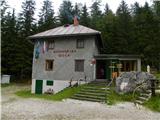
Starting point: Kovinarska koča v Krmi (870 m)
| Latitude/Longitude: | 46,40040°N 13,92300°E |
| |
Route name: hunting path
Walking time: 3 h 45 min
Difficulty: very difficult pathless terrain
Elevation gain: 1144 m
Elevation difference along the route: 1175 m
Map: Triglav 1:25 000
Recommended equipment (summer): helmet
Recommended equipment (winter): helmet, ice axe, crampons
Views: 17.788
 | 2 people like this post |
Access to starting point:
We leave the Gorenjska motorway at the Hrušica exit and follow the road ahead in the direction of Kranjska Gora. Just a little before the village of Dovje, the road to Mojstrana (Vrata, Kot and Krma) branches off to the left from the main road. We follow the road ahead in the direction of the village of Radovna and the valleys of Krma and Kot. The relatively steep road then leads past the TNP sign, after which the road soon levels out and brings us to a crossroads, where a macadam road into the Kot valley branches off to the right. We continue straight on the road, which starts to descend. In the middle of the descent, the road into the Krma valley branches off to the right (straight ahead to Radovna). A little further on, we reach the next crossroads, where we continue right in the direction of Krma. The macadam road then brings us to the Kovinarska koča mountain hut. We park on the arranged parking lot in front of the hut.
Route description:
Behind the mountain hut the hunting trail begins. The path winds straight uphill along the right bank of the gully below Debela peč. Initially the path runs parallel to the gully, later it veers a bit more to the right and winds in switchbacks along the forested ridge. We stick to the most trodden path. The path levels out slightly, followed by crossing the streambed; on the left a cairn directs us forward along the streambed, then left onto the path. The hunting path makes a long left turn, then we cross the streambed again. A view opens to the north wall of Debela peč. The path winds among dwarf pines and grass and higher up approaches the wall completely. At the wall the path turns right (towards the east). The path runs parallel to the wall. When we reach the trees, the path rises and falls a few more times. Soon we notice a parallel path some twenty meters below us just before the wider gully ahead. Along the poorly trodden trail we descend to the lower path. Continuing along the upper path is considerably more demanding - at the crossing of the next gully. Along the lower path we cross two gullies and continue along the path to the main gully. Here the path almost disappears, with only occasional traces remaining. Ahead on the left we see water flowing over a drop. We walk along the wall, picking up the faint path a bit further right. Via the easiest passages we reach the scree with scattered boulders. We head uphill slightly left, aided by a few cairns. Higher up we reach below the drop and climb over it. The first drop is the hardest (II). Above the drop the gully flattens slightly, followed by walking through the rubble-filled gully, easier climbing and two more climbs over drops. The rock is crumbly. Above the last drop the gully opens up. We head a bit further left, reaching the craggy slope over scree. Initially a few cairns help us, later we move by feel along the easiest passages (avoiding the dwarf pines). Soon we spot the marked path. When we reach the path we turn left. We follow the marked path for another 20 minutes to the summit of Debela peč.

Photos:
 1
1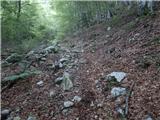 2
2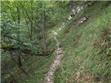 3
3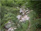 4
4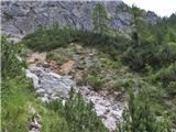 5
5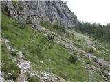 6
6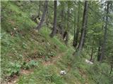 7
7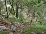 8
8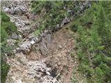 9
9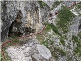 10
10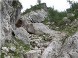 11
11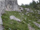 12
12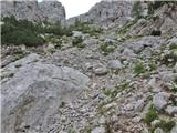 13
13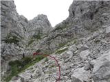 14
14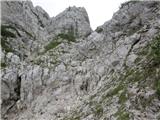 15
15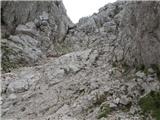 16
16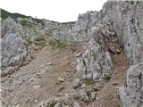 17
17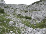 18
18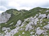 19
19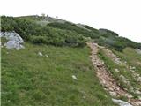 20
20
Discussion about the trip Kovinarska koča v Krmi - Debela peč (hunting path)
|
| ljubitelj gora25. 06. 2015 |
Today went along this hunting path / pathless terrain to Debela peč - Brda - Lipanski vrh. At picture 8 I turned left (I also knew about the right path), it's a bit harder, but you still reach the jump.
|
|
|
|
| ljubitelj gora26. 06. 2015 |
Jump graded II degree and a bit higher another slightly easier one.
|
|
|
|
| ljubitelj gora26. 06. 2015 |
That's what the records say and you also wrote about jumps graded II degree . .
|
|
|
|
| JusAvgustin26. 06. 2015 |
Yeah, up to the ravine there's no jump. And later in the ravine there's a bypass on the right. You probably meant the one under the larch... There is a jump there yeah. From where you turned left it's walking... To the ravine.
|
|
|
|
| mlubej18. 09. 2015 |
Yes, at the first jump you can go around on the right if you want to spoil the fun  The second is a bit longer but rich in holds. Otherwise an interesting and quick access to the Brda-Široka Peč ridge. The second is a bit longer but rich in holds. Otherwise an interesting and quick access to the Brda-Široka Peč ridge.
|
|
|
|
| mlubej18. 09. 2015 |
Oh, Debela Peč...
|
|
|
|
| Peter.B.6. 10. 2019 |
Hello
What are the conditions on this trail?
Best regards.
|
|
|
To post a comment you must log in:
If you do not yet have a username, you must first
register.