Starting point: Krašnja (363 m)
| Latitude/Longitude: | 46,16705°N 14,74278°E |
| |
Walking time: 1 h 15 min
Difficulty: easy marked way
Elevation gain: 410 m
Elevation difference along the route: 410 m
Map: Ljubljana - okolica 1:50.000
Recommended equipment (summer):
Recommended equipment (winter):
Views: 30.185
 | 3 people like this post |
Access to starting point:
A) From the highway Ljubljana - Maribor, we take the Lukovica exit, then we follow the old road towards Blagovica and Trojane. When the road to the settlement Krašnja branches off to the left, we turn right onto a macadam road, along which we park in a suitable place.
B) From the highway Maribor - Ljubljana, we take the Blagovica exit, then we drive along the old road in the direction of Domžale and Lukovica. When the road to the settlement Krašnja branches off to the right, we turn left onto a macadam road, along which we park in a suitable place.
Route description:
At the crossroads, we notice signs for Limbarska gora, which direct us onto a side macadam road that leads in the direction towards the highway. When we get very close to the highway, we go right through the underpass below the highway; on the other side of the highway, from the crossroads we go left. For a short time we continue between the highway and the Radomlja river, then we go right across the bridge over Radomlja; after the bridge, right onto the marked path, which continues for some 10 steps along the left bank of the river. Soon the path turns left and ascends steeply; when it flattens a little, it joins a cart track, which at the junctions we follow in the direction of the blazes. Higher up, we emerge from the forest and at the marked junction, where the path from Gradiško jezero joins from the right, we continue left.
We continue in the direction of Limbarska gora; the path a little further on crosses the asphalt road Krašnja - Moravče. The path ahead leads us along a macadam road, from which we soon go left onto a marked path that gradually enters the forest. After a few minutes we reach a wide cart track, from which the blazes direct us left. There follows a moderate ascent through the forest; when the forest ends, we arrive at a larger hay meadow, where the path turns left. There follows some fairly level walking, then we reach an asphalt road, along which in a few minutes and with ever more beautiful views we ascend to the summit of Limbarska gora, where there is the church of St. Valentine.
Description and pictures refer to the condition in the year 2018 (November).

Photos:
 1
1 2
2 3
3 4
4 5
5 6
6 7
7 8
8 9
9 10
10 11
11 12
12 13
13 14
14 15
15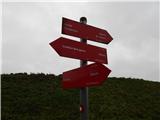 16
16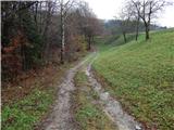 17
17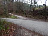 18
18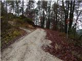 19
19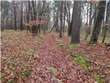 20
20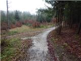 21
21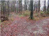 22
22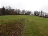 23
23 24
24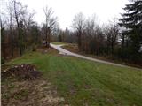 25
25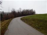 26
26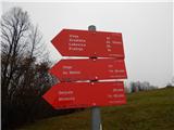 27
27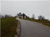 28
28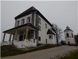 29
29 30
30
Discussion about the trip Krašnja - Limbarska gora
|
| Jaša14. 04. 2010 |
All photos of this hill are only in bad weather. That's why it didn't attract me much upwards.
Last week I casually jumped up and just before sunset a beautiful view of the Kamnik-Savinja and Julian Alps opened up from the top. That's why I'm attaching some "scenic" photos.
|
|
|
|
| Jaša14. 04. 2010 |
I won't attach anything, because obviously it can't be done here... but I just don't know
|
|
|
|
| geppo14. 04. 2010 |
No, you won't succeed here!
Go to "CURRENT CONDITIONS"
Cheers
|
|
|
|
| marjan.majda10. 01. 2011 |
Do you have similar experiences to mine?
We arrived at the top of Limbarska gora and ordered tea at the gostišče.
An older lady-possibly the owner brought it to us and we chatted with friends. Soon she reappeared at the table asking if we would order soup. No, we're going home for lunch soon, we replied.
Then a torrent of words ensued, that we're occupying the table, ordering too little, she has to throw away the soup if she cooks it, and it's not right anyway,...
We stayed silent. We paid for the tea and left.
|
|
|
|
| Primož7610. 01. 2011 |
marjan.majda nothing new. Unfortunately. And yes, she is the owner.
|
|
|
|
| milenula10. 01. 2011 |
We also had a similar experience. When we ordered only tea, the lady commented that we "surely have schnapps with us anyway". By chance we were all abstainers. Otherwise she didn't offer us anything - not even perhaps some dessert, and nothing smelled like any goodies either. Strange gostišče.
Next time we'll avoid it by the widest possible margin.
|
|
|
|
| miri11. 01. 2011 |
We last year went from Limbarska gora towards Trojanam. At a farm through whose yard the marked path runs, we experienced an incredible welcome. The lady of the house served us pastries, the master drinks, and also handed out some brochures. We still remember them today. Hikers from Idrija
|
|
|
|
| miri11. 01. 2011 |
One more thing. I think they are called Baloh.
|
|
|
|
| čemšeničan12. 01. 2011 |
Come to Čemšeniška planina up there, nothing works if you order only tea Lp.
|
|
|
|
| JusAvgustin12. 01. 2011 |
in bivouacs there is excellent service! but I avoid huts, because my paths rarely take me nearby. I remember service in the double! invaluable.
|
|
|
|
| Rožmarin13. 03. 2011 |
Yes, thanks for the recommendation. We're heading to Limbarska gora with the family for the first time and I see that the "backpack" will be heavy again since due to unfriendliness we'll have to carry tea in a thermos too.http://www.hribi.net/slike/redface.gif
|
|
|
|
| Lucy13. 03. 2011 |
I decided to go to Limbarska gora via Gradiško jezero, the path led me through forest paths and past the villages of Vinje and Negastn. The path itself was easy and simple, I walked for an hour and a half. There were a lot of people because there was the traditional nail hike, which locals organize every year. There were stalls offering food and drinks, and also various ensembles that livened up the event. I liked it, which means I'll definitely visit Limbarska gora again.
|
|
|
To post a comment you must log in:
If you do not yet have a username, you must first
register.