Kriška planina - Košutna (via planina Košutna)
Starting point: Kriška planina (1480 m)
| Latitude/Longitude: | 46,29290°N 14,53690°E |
| |
Route name: via planina Košutna
Walking time: 2 h 5 min
Difficulty: partly demanding marked way
Elevation gain: 494 m
Elevation difference along the route: 600 m
Map: Kamniške in Savinjske Alpe 1:50.000
Recommended equipment (summer): helmet
Recommended equipment (winter): helmet, ice axe, crampons
Views: 29.655
 | 4 people like this post |
Access to starting point:
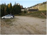
A) From the Ljubljana–Jesenice motorway, take the Vodice exit, then continue driving to the first signalized intersection in Vodice, where you turn left towards Cerklje na Gorenjskem and Brnik. When you reach the main roundabout in Spodnji Brnik, continue driving towards Cerklje and the Krvavec ski area. At the end of the settlement of Cerklje na Gorenjskem, leave the main road, which continues towards Velesovo and Visoko, and continue slightly right onto the road towards the Krvavec ski area. You then reach the village of Grad, where signs for the settlement Ambrož pod Krvavcem direct you right onto a steep asphalt road (straight ahead: lower station of the monocable gondola on Krvavec and Štefanja Gora). When the gradient of the steep road eases slightly, you reach an intersection, where you continue left towards the settlement Ambrož pod Krvavcem (straight ahead: settlements Ravne, Apno and Šenturška Gora). A little further on, the road temporarily descends slightly, then climbs through occasionally very panoramic slopes. Higher up, you reach Ambrož pod Krvavcem, where you pass the church of St. Ambrož and the tourist farm Pr Ambružarju on the left. From the tourist farm onwards, the road enters the forest and climbs through it all the way to Planina Jezerca, where there is a large arranged parking lot. Here the road levels out and turns left; about 500 m further on it brings you to an intersection, where you continue right towards Kriška planina (straight ahead: upper station of the monocable gondola and Planinski dom na Gospincu). There follows only a short steep ascent to the parking lot on the edge of Kriška planina.
The road from Planina Jezerca to Kriška planina is now closed to public traffic; this extends the approach by about 15 minutes.
B) From the Jesenice–Ljubljana motorway, take the Kranj–East exit, then continue driving towards Brnik, Komenda and Mengeš. When you reach the main roundabout in Spodnji Brnik, continue driving towards Cerklje and the Krvavec ski area. At the end of the settlement of Cerklje na Gorenjskem, leave the main road, which continues towards Velesovo and Visoko, and continue slightly right onto the road towards the Krvavec ski area. You then reach the village of Grad, where signs for the settlement Ambrož pod Krvavcem direct you right onto a steep asphalt road (straight ahead: lower station of the monocable gondola on Krvavec and Štefanja Gora). When the gradient of the steep road eases slightly, you reach an intersection, where you continue left towards the settlement Ambrož pod Krvavcem (straight ahead: settlements Ravne, Apno and Šenturška Gora). A little further on, the road temporarily descends slightly, then climbs through occasionally very panoramic slopes. Higher up, you reach Ambrož pod Krvavcem, where you pass the church of St. Ambrož and the tourist farm Pr Ambružarju on the left. From the tourist farm onwards, the road enters the forest and climbs through it all the way to Planina Jezerca, where there is a large arranged parking lot. Here the road levels out and turns left; about 500 m further on it brings you to an intersection, where you continue right towards Kriška planina (straight ahead: upper station of the monocable gondola and Planinski dom na Gospincu). There follows only a short steep ascent to the parking lot on the edge of Kriška planina.
The road from Planina Jezerca to Kriška planina is now closed to public traffic; this extends the approach by about 15 minutes.
Route description:
From the parking lot, head onto the road towards Planina Koren. The road then takes us through an underpass to a quarry, where we leave it. Continue ascending along a pleasant but poorly visible mountain path that runs along the edge of the pasture fence. The path, which becomes more visible, then leaves the grazing areas of Kriška planina and enters terrain overgrown with dwarf pines. After a short ascent, the path brings us to a fine vantage point from which a nice view opens up over the Korošica valley. Further on, the path starts to descend more steeply and after a few minutes we are already 60 m lower. The path then levels out and from the right a path joins us from the aforementioned valley. Next we cross a strip of forest, and the path then starts ascending again. During the ascent, an unmarked path branches off to the left leading to Sedlo Razor; we continue on the marked path, which after a few more minutes brings us to the southern part of Planina Koren. The path then descends past a watering place for animals to the shepherd hut on the planina.
Here at the hut, slightly to the right (southeast direction), a path branches off leading to Planina Košutna. The path first crosses the slopes almost horizontally, then brings us to a technically demanding spot. The path climbs steeply over a short rocky step, where fixed safety aids assist us. The path then levels out and takes us past a cross to Planina Košutna, where there is a chapel and a shepherd shelter.
From the planina, continue on a poorly trodden path that goes to the left of the chapel amid the dwarf pines. Ahead, the path ascends gently along the moderately steep and panoramic slope of Košutna. When the path levels out completely, the path to the summit of Košutna branches off to the right (the junction is marked, but the path is incorrectly marked). We follow this very poorly visible path all the way to the summit, which we reach after 15 minutes of further walking (keep to the left passages, even though the markers in the lower part direct us right).
The path is marked but in places difficult to follow. If you lose the path, look for a passage through the dwarf pines and take care not to get entangled in them.
Kriška planina – Planina Koren 1:15, Planina Koren – Košutna 50 minutes.

Photos:
 1
1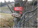 2
2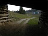 3
3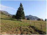 4
4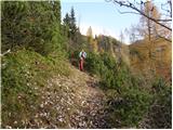 5
5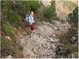 6
6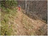 7
7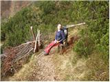 8
8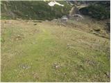 9
9 10
10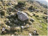 11
11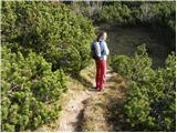 12
12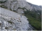 13
13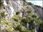 14
14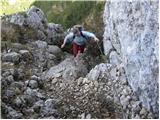 15
15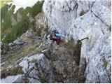 16
16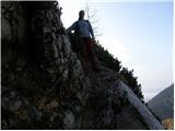 17
17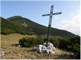 18
18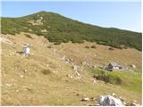 19
19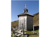 20
20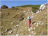 21
21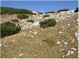 22
22 23
23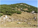 24
24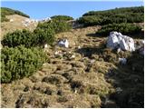 25
25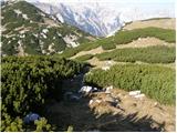 26
26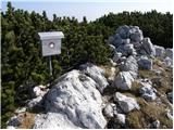 27
27
Discussion about the trip Kriška planina - Košutna (via planina Košutna)
|
| Kriška7. 11. 2008 |
I have a nice memory of this interesting path from two years ago - we arrived at the chapel and shepherd's hut on the planina just when there were some people who had had mass in the chapel before and then were having a little refreshment in front of the hut. The main speaker in the cheerful group (which we joined for a while) was a very sympathetic gentleman whom I still like to remember - the parish priest from Trzin, Mr. Pavle. If he ever reads these pages - warm greetings from the Tržič area and hope to see you again!
|
|
|
|
| krsto7127. 11. 2011 |
Nice excursion...Today walked it as described, but parked at the end of asphalt before the barrier (Planina Jezerca), and extended the trip to Kompotela. Markings to Košutna obviously improved since the author wrote the description, as they lead directly on the path through scree to the summit, the path is also well visible and marked. From Košutna summit I found a path through scree (visible trodden track) towards Kompotela and reached directly below Kompotela saving half an hour of walking on the marked trail. Excellent trip, but spoiled a bit on return by the view of Kriška planina - display of sheet metal everywhere - access roads, meadows...Perhaps those responsible should consider keeping the barrier at the end of asphalt closed (except for caretakers and staff...) to prevent mass "car" tourism on the mentioned pasture...
|
|
|
|
| ciklama28. 03. 2012 |
Today we walked the described path, which is newly marked and very exemplarily signposted (bravo PD Komenda!). In some places, especially higher up, there is still quite a bit of snow and conditions are still quite wintry. From the top of Košutna we went to Kompotela and enjoyed the beautiful views of KSA. It was a wonderful day for relaxation and recharging batteries!
|
|
|
To post a comment you must log in:
If you do not yet have a username, you must first
register.