Legastja - Dom na Govejku (po cesti)
Starting point: Legastja (450 m)
| Latitude/Longitude: | 46,1072°N 14,3498°E |
| |
Route name: po cesti
Walking time: 45 min
Difficulty: easy marked way
Elevation gain: 280 m
Elevation difference along the route: 284 m
Map: Ljubljana - okolica 1:50.000
Recommended equipment (summer):
Recommended equipment (winter):
Views: 48.732
 | 5 people like this post |
Access to starting point:
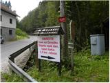
From Medvode we drive to the village of Sora, from where we continue driving towards the village of Topol (Katarina). After a few km of driving from the village of Sora, we reach the Legastja inn, which is the starting point for our trail. We park at one of the several smaller parking lots along the road before or behind the mentioned inn. Parking at the lot in front of the inn is permitted only for guests.
Route description:
From the starting point we head onto the forest road towards Dom na Govejku, which begins to ascend moderately through the forest. After a few minutes we cross a stream, then we ascend to a small junction where the path splits.
We continue along the left road (right is the marked footpath to Dom na Govejku, which is somewhat longer), which ascends through the forest for some time more, then brings us to scenic grassy slopes from which a nice view of the surrounding hills opens up. The road then returns to the forest and brings us after approximately 35 minutes of walking from the starting point to a rocky cut, where we leave the forest again, and a nice view opens towards Sv. Jakob, the elevation on the other side of Ločnica.
Another approximately ten minutes of walking follows along a moderately steep road and the path brings us to Mihelčičev dom na Govejku.
Photos:
 1
1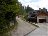 2
2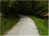 3
3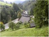 4
4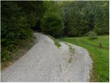 5
5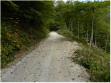 6
6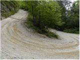 7
7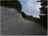 8
8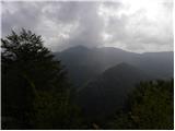 9
9 10
10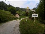 11
11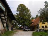 12
12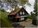 13
13
Discussion about the trip Legastja - Dom na Govejku (po cesti)
|
| Gost27. 01. 2007 |
In the winter idyll, this excursion is wonderful and passable despite the snow, beautiful views open up at the top 
|
|
|
|
| Damijan13. 05. 2007 |
In short, an afternoon hike. And you get good schnitzel up there.
|
|
|
|
| Gost4. 11. 2007 |
Nice hike in summer and winter. But I miss the "soul" in the hut itself! I believe the people working there try, but to me it's missing the right atmosphere, sometimes the boules players created it, but sadly there are none anymore. Nice little greeting - JURE
|
|
|
|
| Gost12. 01. 2008 |
Since we have a rainy weekend ahead, Govejek is a suitable goal for a trip. Since we ascend on the road we can easily take an umbrella without problems.
|
|
|
|
| Gost13. 01. 2008 |
You can go on the path to Osolnik, but a little before the summit turn left, there is a mark and head to Petelinjek, then continue to Govejek. Return on the road that leads to Govejek and past Gostilna Lagastja and on the road to the starting point at Osolnik, where you left the car. This way you make a circular trail and it's quite pleasant and interesting and not strenuous. You walk about three hours - rather slowly. In nice weather you enjoy the beautiful and peaceful surroundings.Best regards
|
|
|
|
| počasni8. 11. 2008 |
You can go at that junction below Osolnik with signs to Gontarska planota and down the other side. When you reach the path connecting Gonte and Govejek, turn left and you're at the hut in 10 minutes.
From the hut you can descend to the starting point (Ločnica) past "Micka" (who sometimes gets angry if people walk on the marked path through her yard, but no need to get upset) and then steeply down, across the stream and you're back on the Ločnica - Osolnik path.
|
|
|
|
| lubi19. 11. 2008 |
A short explanation about the SOUL at Govejku. Something was missing when the caretaker Silvo left. So we redirected to Osolnik to Iva and Tone. You'll find the soul here now. Afternoon jump to the top, pleasant company and return with battery charged - magically beautiful. Will you check it??
Nadka
|
|
|
|
| viharnik12. 11. 2008 |
Nice, little-known path to Tošč 1021m, passes by the Trnovec settlement. Here we turn at the only junction from the main road that leads further to Topol, right. Leave the car on the main road, before the junction, left (large parking lot). After five minutes of walking, notice the second road junction right. Up there, past the Omejc farm (annoying dog!). Behind the farm, in the woods, notice a narrow cart track that winds all the way to the ridge, which turns right down to the Kozjek farm. We continue straight along the straightening. Further on, signs direct us to the marked path (ridge M. Tošč - Tošč). Right here, in a quarter of an hour, to the summit.
|
|
|
|
| falcon2. 02. 2011 |
After the change of caretakers, Miheličičev hut is like reborn. Service is excellent, the hiker is warmly welcomed and the food is super. In short, nice.
|
|
|
|
| plavžar9. 04. 2012 |
Hut at Govejek closed due to renovation!
|
|
|
|
| slavkoo23. 03. 2013 |
Hut on Govejek OPEN on Fridays, Saturdays and Sundays... also holidays.
|
|
|
|
| lelika16. 03. 2014 |
On March 8th we went to Govejk through the forest past Micka - maybe really thoughtless but we were already almost halfway so we persisted to the end - the path is still completely impassable as expected because the ice storm caused huge damage - up it took us 2 hours instead of 45 minutes so I advise against any ventures there through - the road is cleared so head up by road - the hut is full anyway - you can see the keeper is good - ocvirkovca yummy - we didn't go to Osolnik afterwards because we didn't know what the path there is like, and that day we had climbed enough
|
|
|
|
| Gora Trma3. 06. 2014 |
@lelika
The path you describe is the only uncleared one. All other paths around Govejek, from there down and up are really well cleared.
It's now one year since the hut was renovated and it's open every day except Mondays from 8h to 20h.
This info will probably come in handy for someone. Good luck!
|
|
|
|
| LidijaJesih3. 06. 2014 |
Let me add a sentence myself. The path is almost cleared (yesterday), there's another hundred meters of scrambling in between, but it's passable. You can see they're clearing it from both sides. Otherwise kudos to PD Medvode, with all that blowdown they managed a lot of work.
|
|
|
|
| JusAvgustin9. 05. 2018 |
My son lost a light blue jacket made to order by our manufacturer Gornik with fluorescent yellow zippers and hood along the path some time ago. On the left sleeve of the jacket is written CENE. It's mainly about sentimental value, as he got the jacket from me for his birthday. If anyone notices the jacket along the path or in the hut, even though I immediately called the Dom na Govejku and the owner assured me there is no jacket there, please let me know on ZS or right here. My son will be very grateful to you.
Thanks
|
|
|
|
| gulbo21. 04. 2021 09:39:01 |
I advise against this path. Already just above Legastja two dogs attacked me, a bit further they have deliberately parked agricultural machinery across the entire path. Obviously someone here is making a great effort to drive away hikers and cyclists.
|
|
|
|
| Lisica21. 04. 2021 21:36:43 |
@Gulbo Next time from Legastja rather go the other direction, to Jakoba, nice and solitary path. The only thing that attacked me there were ticks. 
|
|
|
|
| GregorD21. 04. 2021 21:57:33 |
@Gulbo, this February I went along the lower path (picture 5 right). The path is marked, slightly longer, didn't encounter dogs or agricultural machinery.
|
|
|
|
| gulbo22. 04. 2021 10:04:45 |
@GregorD - well then I rerouted to the lower marked path. By bike. Well, it somehow worked, although the path is not really meant for bikes. On the exposed section I just pushed. Down I went the other side, by road. Didn't meet anyone, also the house at the junction with the upper road looks abandoned.
@Lisica, thanks for the good suggestion.
|
|
|
To post a comment you must log in:
If you do not yet have a username, you must first
register.