Ljubelj - Begunjščica (through the Central gully, snowy approach)
Starting point: Ljubelj (1058 m)
| Latitude/Longitude: | 46,43240°N 14,26020°E |
| |
Route name: through the Central gully, snowy approach
Walking time: 2 h 45 min
Difficulty: very difficult pathless terrain
Elevation gain: 1002 m
Elevation difference along the route: 1002 m
Map: Karavanke - osrednji del 1:50.00
Recommended equipment (summer): helmet
Recommended equipment (winter): helmet, ice axe, crampons
Views: 32.600
 | 1 person like this post |
Access to starting point:
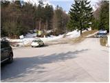
From the highway Ljubljana - Jesenice we take the exit Ljubelj and follow the road ahead to the border crossing. Just a few meters before the border crossing signs for Zelenica point us to the left and after some 10 meters of additional driving the road brings us to the parking lot below the ski center Zelenica.
Route description:
From the parking lot, we head onto the footpath in the direction of Zelenica, Vrtača and Stol. The cart track, which runs along the left side of the ski slope, after approximately 15 minutes of moderate ascent through the forest brings us to the aforementioned slope along which we then ascend. The path, which offers nice views of the extensive scree fields of Begunjščica on the left and the ridge of Ljubeljščica on the right, then in a gentle ascent brings us to the hut on Vrtača.
From the hut, we continue straight on the marked path, which slowly turns slightly to the left and after a shorter diagonal ascent brings us into the belt of dwarf pines. Further, the path steeply ascends for a short time and then brings us to the cart track (transport-rescue road), which we follow in a moderate ascent to the mountain hut Dom na Zelenici.
During the operation of the ski slope, walking on the ski slope is forbidden. At that time we use the winter path, which runs along the transport-rescue road.
From the hut on Zelenica we head to the south side towards the northern wall of Begunjščica. The direction is shown by a wide gully, which narrows in the middle part and widens again higher up. We ascend it to the rocky barrier, where walls from the left and right increasingly close it off. On the right we see a short gully, on the left a steep rocky step. In the middle is a narrow gully up which we ascend. Over a short step we reach a somewhat wider gully, which flattens and widens. To the right we ascend to the shoulder from where Veliki plaz (Smokuški plaz) is visible. From here the summit is already visible, which we reach in a few minutes.
The steepness of the slope is up to 45°.

Photos:
 1
1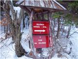 2
2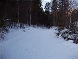 3
3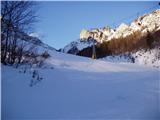 4
4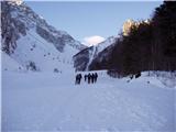 5
5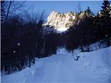 6
6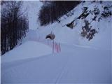 7
7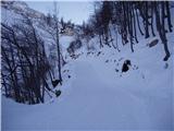 8
8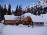 9
9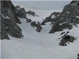 10
10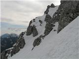 11
11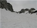 12
12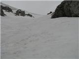 13
13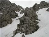 14
14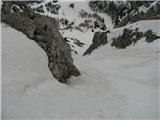 15
15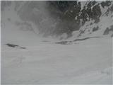 16
16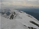 17
17
Discussion about the trip Ljubelj - Begunjščica (through the Central gully, snowy approach)
|
| JusAvgustin10. 12. 2010 |
Today we nailed it. Just after 14:00 we started from Ljubelj, at the main summit we stood exactly 15 min before sunset. Incomprehensibly beautiful to watch the sunset from the highest peak of the Radovljica municipality... When the sun had completely set, we descended via Šentanski plaz. We appropriately finished the tour with a good beer at the "basement" When the sun had completely set, we descended via Šentanski plaz. We appropriately finished the tour with a good beer at the "basement"
Conditions: apart from the strong wind that literally moved us around the central gully and blew in gusts the whole way, conditions were ideal! Snow is bonded to the base, doesn't sink in (except in drifts), temperature well below 0, otherwise phenomenal powder from start to finish. We descended already in complete darkness. Gear: crampons, ice axe, helmet, headlamp... Enjoyed on your behalf, Jože and Juš
|
|
|
|
| primozs22. 12. 2012 |
Today we headed to Begunjščica. Ski touring of course. Little snow, too little for skiing. Snow from gully very very hard. Thighs burning like hell. Upper gully part wind-packed. Untreated snow (lumpy snow) all way to top.
|
|
|
|
| gj29. 01. 2015 |
Fantastic crampons (squeak, squeak)
|
|
|
|
| subaru7. 04. 2015 |
Yesterday we ascended with friends up the Central gully and descended the Šentanski plaz. Conditions for hikers super. The jump in the gully is nicely filled. Only the strong wind bothered a bit, but before the snow shower we were already in the hut at Zelenica.
|
|
|
|
| Planinec48. 04. 2015 |
On Saturday I plan to go to Begunjščica via the central gully.. can you tell me what the conditions are like? regards
|
|
|
|
| subaru8. 04. 2015 |
Planinec4 - read the previous article.
|
|
|
|
| matej20009. 04. 2015 |
Yes, conditions are great, I was there yesterday.
|
|
|
|
| Barentoter19. 01. 2016 |
Hi, interested in the conditions in the central gully. Is it already nicely filled for ice pick climbing?
|
|
|
|
| Barentoter20. 01. 2016 |
Thanks Bojan. At least temperatures are favorable, even if snow is insufficient
|
|
|
|
| MiG19. 03. 2017 |
Hello everyone. Interested in the current situation in Osrednja grapa? Will climbing be possible next weekend, 25.-26.03.2017. and is it dangerous due to avalanches?
Thanks!
|
|
|
|
| MiG19. 03. 2017 |
Thanks Bojan. But rain is forecasted for that weekend so I'm a bit cautious. :/ What do you think? I'm not very experienced with couloirs. This would be my first.
|
|
|
|
| Prefrigan4. 01. 2020 |
Hi, what are the current conditions, is there enough snow for a normal winter ascent? Up here and back via Setnjanski? Thanks & regards
|
|
|
|
| Marty16. 01. 2025 15:22:19 |
Hi, what are the current conditions? Back via Šentlanc. Thanks lp
|
|
|
|
| stankoju16. 01. 2025 18:08:00 |
Write under the Begunjščica forum, you'll probably get a reply sooner there.
Lp
|
|
|
|
| Marty17. 01. 2025 10:37:08 |
|
|
|
To post a comment you must log in:
If you do not yet have a username, you must first
register.