Ljubelj - Vertatscha/Vrtača
Starting point: Ljubelj (1058 m)
| Latitude/Longitude: | 46,43240°N 14,26020°E |
| |
Walking time: 3 h 30 min
Difficulty: partly demanding marked way
Elevation gain: 1123 m
Elevation difference along the route: 1123 m
Map: Karavanke - osrednji del 1:50.000
Recommended equipment (summer):
Recommended equipment (winter): ice axe, crampons
Views: 244.842
 | 16 people like this post |
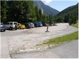
Access to starting point:
From the highway Ljubljana - Jesenice, we take the Ljubelj exit and follow the road ahead to the border crossing. Just a few meters before the border crossing, signs for Zelenica direct us to the left and after some 10 meters of additional driving, the road brings us to the parking lot below the ski center Zelenica.
Route description:
From the parking lot, we head onto the footpath in the direction of Zelenica, Vrtača and Stol. The cart track, which runs along the left side of the ski slope, brings us after approximately 15 minutes of moderate ascent through the forest to the aforementioned slope, along which we then ascend. The path, which offers nice views of the extensive scree fields of Begunjščica on the left and the ridge of Ljubeljščica on the right, then brings us in a gentle ascent to the hut on Vrtača. From the hut, we continue straight on the marked path, which slowly turns slightly to the left and after a shorter traverse ascent brings us into a belt of dwarf pines. Further on, the path ascends more steeply for a short time and then brings us to a cart track (transport rescue road), which we follow in a moderate ascent to the mountain hut on Zelenica.
From the hut on Zelenica, we continue right in the direction of Stol and Vrtača (left Begunjščica) on the path which immediately after the hut turns left and ascends beside the children's ski lift. Somewhere halfway along the lift, we reach a less noticeable junction, where we continue right and ascend transversely across the ski slope (straight to the hut at the source of Završnica). Further on, we cross a short belt of forest and the path brings us to the next lift, which we cross in a gentle descent. On the other side of the ski slope, we notice a larger rock with a marking on it that directs us into the forest. The path ahead first descends slightly, then ascends transversely across the scree. The path soon levels out and turns somewhat to the left, where we reach a smaller unmarked junction. We continue straight on the gentle and marked mountain path, which a little further brings us to the place where an unmarked path branches off to the right into the valley of Suhega ruševja (cairn).
The path ahead ascends transversely along the southern slopes of Vrtača. The path, which partly runs through the forest and partly across extensive scree fields, then brings us higher to a marked junction, where we continue right in the direction of Vrtača (straight Stol). The path ahead begins to ascend more steeply, first through a belt of dwarf pines, higher across extensive grassy slopes. On these grassy slopes, an unmarked path from the saddle Šija joins almost imperceptibly from the left, but we continue on the marked path, which steeply ascends toward the side ridge of Vrtača. Higher up, the path turns slightly to the left, crosses steep partly rocky slopes and after a few minutes of further walking brings us to the aforementioned ridge, where the path turns sharply to the right. The path ahead begins to ascend steeply on very steep and slippery-dangerous slopes. Higher up, the path brings us to the main ridge of the Karavanks, where it levels out. This is followed by approximately 20 minutes of walking along and on the ridge, which is somewhat exposed in places and slippery-dangerous throughout the section. We then follow this panoramic path all the way to the summit of Vrtača.
Ljubelj - Zelenica 1:20, Zelenica - Vrtača 2:10.

Photos:
 1
1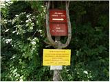 2
2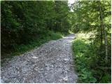 3
3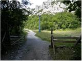 4
4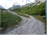 5
5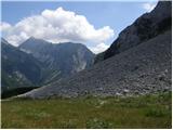 6
6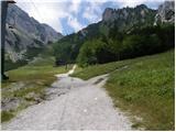 7
7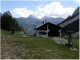 8
8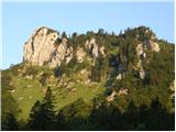 9
9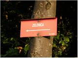 10
10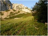 11
11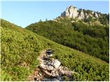 12
12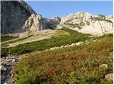 13
13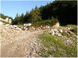 14
14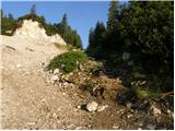 15
15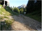 16
16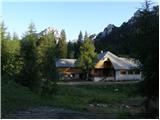 17
17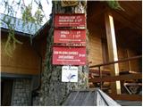 18
18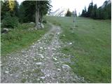 19
19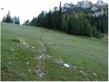 20
20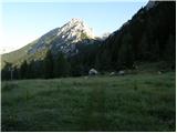 21
21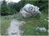 22
22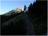 23
23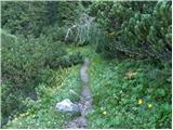 24
24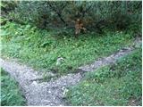 25
25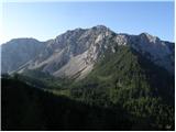 26
26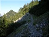 27
27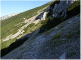 28
28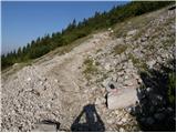 29
29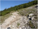 30
30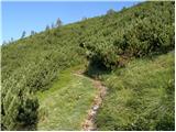 31
31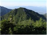 32
32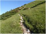 33
33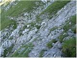 34
34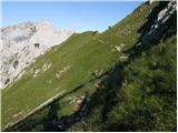 35
35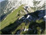 36
36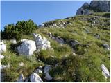 37
37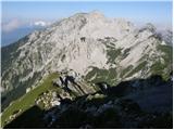 38
38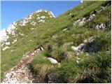 39
39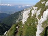 40
40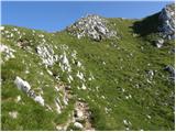 41
41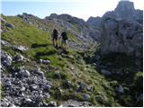 42
42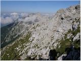 43
43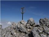 44
44 45
45
Discussion about the trip Ljubelj - Vertatscha/Vrtača
Show older messages
|
| Gost23. 09. 2006 |
Quite a long tour, but nicely "distributed": rest at Zelenica then on the grassy plateau before the summit part - nice!
|
|
|
|
| Kriška12. 11. 2006 |
I recommend visiting Vrtača in early summer, the southern slope over which we walk for quite a while is full of mountain carnations (pinks), the whole path is so "scented" that I could recognize it later by smell alone, even if I didn't know where I was! 
|
|
|
|
| SuperNejc16. 07. 2007 |
One of the most beautiful tours for undemanding hikers in the Karavanke! The summit rewards with an exceptional view; only Triglav remains hidden, shyly hiding behind the summit of the neighboring Stol.
During the descent, watch out for rocks that can break loose and fly into the valley in areas crossed by hikers. PD Tržič advice, to equip the summit with a stamp and a new visitors' book.
|
|
|
|
| Gost17. 07. 2007 |
I agree that Vrtača is always, really always, beautiful: both in spring with lush flowers and the last weekend in October when the eye rests on golden larches. I just haven't "pushed" up there in winter yet. Well, maybe this year. Good luck!
|
|
|
|
| Gost19. 07. 2007 |
I agree with the previous one. Vrtača is most beautiful when there's no fear of fog engulfing it like Stol. For Tržič residents one of the most beautiful peaks if we exclude Zelenjak or "Možje". If there's such rich alpine flora somewhere, I hope it remains as pristine as it is here with us in Gorenjska.
Cveto
|
|
|
|
| taš7. 08. 2007 |
On Sunday I was on Vrtača for the first time and was pleasantly surprised. I was lucky it was "cloudless" and the view was really magnificent. The path wasn't strenuous, perhaps towards the summit over rocks, because I'm a bit prone to vertigo.
|
|
|
|
| Silence23. 12. 2007 |
Nice sunny day, no wind. A track has been made to the summit. On the southern slope, the lower sections are already completely dry. Towards the top there is more snow, the path is slightly icy in places but no problem with winter gear. Great care is needed against slipping.
P.S. On the summit it was almost short-sleeve weather
|
|
|
|
| Gost18. 02. 2008 |
Just yesterday (17 February 2008) my partner and I were there. Towards the top it drags a bit, but once you're at the top you know it's worth it... Despite the abundance of snow, there was no problem. But you need to watch every step, you can slip (and quite fast) even in the snow.
Best regards, Tina&Boštjan
|
|
|
|
| andrej jerina29. 06. 2008 |
Yesterday Franci and I, besides the ascent to Belščica, also did the ascent to Vrtača. There's no sense wasting words on the mountain, it's too beautiful, as is the flowers adorning it. Only missing a stamp at the summit.
From the ridge we then crossed the scree under Vrtača, which faces Stol. The path is not drawn on the Karavanke map. The path is nicely laid out in a slight descent towards the Belščica saddle and is also marked. I recommend it, as with this path we can shorten the approach to the saddle. LP Andrej
|
|
|
|
| majdicst26. 07. 2008 |
Today we conquered this peak. The description is quite accurate, maybe I'd just add that the path along the ridge is quite "airy" in places. A bit awkward on the steepest sections, where it can be slippery on wet ground. At the top there's not much space, and it was windy. The view is fantastic. Stol got its hat several times, so we soon turned back to the valley and on the last descent from the middle cable car station it already sprinkled us a bit.
Surprisingly, there weren't too many visitors.... probably almost all went to Begunjščica or Stol.
In the hut at Zelenica you get only coffee, tea and drinks. At the middle station there's nothing with a hut (closed), at Ljubelj everything closed. So... take something to eat with you.
|
|
|
|
| johnybravoslo7. 08. 2008 |
Yeah Vrtača, you'll fall next weekend...
|
|
|
|
| MiR7. 08. 2008 |
Dear mountain friends, don't think that a mountain falls, nor do we conquer it, nor seize it... the mountain just allows us to climb to its summit, to rest on it, to fill our heart and soul, to enjoy looking far around... When we leave the mountain, it stays there waiting for others to visit it. Have you ever thought why you sometimes had to turn back just below the summit and go to the valley (sometimes even disappointed) without reaching your goal? The mountain already knew why it didn't allow you to reach the top. And despite different understandings in achieving your goals, I wish you luck on all paths and much satisfaction on the summits.
|
|
|
|
| johnybravoslo14. 08. 2008 |
Thanks MiR. I didn't mean "fallen" quite literally. The rest is crystal clear to me. Even when we're gone it will still remain there for all generations to come.
:-)
|
|
|
|
| naša19. 09. 2008 |
That "Rubik's cube" up there really surprised me  . Too bad I didn't have a camera. A little below the summit, I also saw gentians. . Too bad I didn't have a camera. A little below the summit, I also saw gentians.
|
|
|
|
| mstrman24. 07. 2009 |
Can someone tell me if it's possible from Zelenica, right up through the screes to Vrtača, then from Vrtača straight a bit down to the saddle and to Stol and back to Zavirska planina and to Zelenica. I'm asking because the path is not drawn, but it goes from Zelenica the upper path towards Stol and in the middle it branches off to Vrtača, otherwise the path is visible up through the screes but I don't know if it reaches the top.
|
|
|
|
| štempilka4. 07. 2009 |
Yes of course you can get there. A bit after Zelenica turn right towards Suho ruševje over the ridge to the top. Back as you wrote. It's a very nice tour. From Zelenica it's about two hours. Off you go happily, good luck.
|
|
|
|
| mstrman25. 07. 2009 |
Thanks (stamp) I'll go in the near future, just need to catch weather with sun all day, because the tour will be long and I don't want to get caught by rain like yesterday on Begunjščica.
P.S. you know what beautiful gentians I photographed yesterday on Begunjščica, just don't know how to upload them here.
|
|
|
|
| heinz5. 07. 2009 |
In the "Conditions" section where you comment on your trips, on the right side there is the pictures (publish) option. A new window opens, you select picture/s from your folder, upload, finish uploading, that's it. Simple as beans.
So the gentians are already there?
|
|
|
|
| Johny7730. 07. 2009 |
nice tour in autumn I'll go up to Karawanks
|
|
|
|
| upornica24. 08. 2009 |
Yesterday I was one of many on Vrtača. I met at least 30 mountaineers. There was quite a crowd at the top. Also we had to step aside for each other quite a bit on the path, which took us some time. From Zelenica to the top I needed more than two hours.
At the top there is only the logbook, no stamp.
|
|
|
|
| Brinova_Sara1. 09. 2009 |
Hi!
Today I was on Vrtača and it was great! The choughs livened up the tour a bit.
The stamp is available at the hut on Zelenica, just ask the friendly caretakers and there'll be no problem. The summit logbook was just filled up today.
Nice evening,
Sara
|
|
|
|
| Lothar8. 06. 2010 |
Was up there on Saturday (5.6) in the morning.
Saw a chamois that gave me a good "stare" and then ran away.
Since I started the trail very early (Ljubelj - 4:50), I was mostly in the shade on the way up, because Ljubeljšica takes the sun from the lower parts of Vrtača at this time of year. Still, there was a very nice view of the sunny Begunjščica. And no people yet. 
I reached the summit around seven, where pleasant morning sun was shining and a moderately strong wind was blowing (doesn't bother me).
In short, I recommend a visit.
|
|
|
|
| Gorski Jelen30. 06. 2010 |
On Sunday (27.6) I took advantage of the wonderful day and already parked at Ljubelj at 5:45. Nice sunny weather, but on the slopes of Vrtača it was blowing quite a cold wind in places. So to the top I put on and took off the windbreaker at least five times. Good that there's an ice axe at the top so you can hold on so the wind doesn't blow you away. Well, it wasn't that bad, the offered views were wonderful, the path beautiful and strewn with flowers. On the ridge there are even two small patches of snow. But it was worth getting up early to reach the top already at 8:00. On the way back I met quite a few hikers who had set themselves to conquer the same goal as me, and on the top very little space. I'm really curious what it looked like up there an hour later. Good that there's an ice axe at the top so you can hold on so the wind doesn't blow you away. Well, it wasn't that bad, the offered views were wonderful, the path beautiful and strewn with flowers. On the ridge there are even two small patches of snow. But it was worth getting up early to reach the top already at 8:00. On the way back I met quite a few hikers who had set themselves to conquer the same goal as me, and on the top very little space. I'm really curious what it looked like up there an hour later. In short, a wonderful mountain, highly recommended - just get up early. In short, a wonderful mountain, highly recommended - just get up early.
|
|
|
|
| efes2. 08. 2010 |
Today my brother and I went up there, really nice tour, recommend to all, just start hiking early
|
|
|
|
| roger15. 08. 2010 |
Best regards!
I'm planning a trip to Vrtača and I'm interested in the exposure in the upper part (ridge)?
Many thanks for answers and happy holiday evening
|
|
|
|
| Bizy15. 08. 2010 |
To me it doesn't seem particularly exposed, some slightly steeper section and some narrow part, nothing shocking, but you step more carefully and pass by. On the way back, be careful for slips both on the upper and lower ridge.
The bigger problem on Vrtača is fog, mainly because of the views, the trail is excellently marked from start to summit. Stamp in Dom na Zelenici, summit logbook... What else?
Happy hiking.
|
|
|
|
| robter20. 08. 2010 |
On Monday 16.8 I was up there. From Ljubelj to Zelenica black clouds, from Zelenica to where the path below the summit turns right it was still quite okay, then strong wind that accompanied us to the top. At the top just an entry in the book and then descent to the basin where we had a snack. Meanwhile the wind dispersed the clouds, so I saw Begunjščica for a moment, when I took out the camera and turned it on, it had already disappeared into the clouds.
Exposed, i.e. dangerous for slipping, the path is only at two or three places, where you need to be a bit more careful than usual.
|
|
|
|
| velkavrh12. 05. 2011 |
I'm interested if anyone went up in the last days. Is there any snow? Vrtača as the second highest peak of Karavanke surely deserves a visit. L.P.
|
|
|
|
| skalar5013. 05. 2011 |
completely fresh ... it's true as "klm" says ... otherwise these days in the hut on Zelenica - judging by short chat with caretakers - finishing last details and after recent installation of sewage plant still technical handover signature and ...
It is open on nice weekends (food too)
|
|
|
|
| jackman7. 07. 2011 |
Nothing special. Nice path, above all easy. Stol was in clouds today, but I was lucky with the sun. The hut at Zelenica is open, the offer in it below average.
|
|
|
|
| dolenjc11. 08. 2011 |
Today I was at Vrtača. Very nice path, weather you could only wish for, wonderful views, Veliki Klek within reach, no crowds, on the way back visit to the hut at the source of Završnica, wonderful staff, food too, at Zelenica a stamp because there isn't one up there, to Ljubelj and towards Nm.
I warmly recommend to anyone who wants peace, quiet, beautiful views. 
|
|
|
|
| tončka29. 08. 2011 |
What is the difference in difficulty and exposure between Begunjščica and Vrtača? I haven't been on either yet and would like to choose "the easier one" for the first time.
|
|
|
|
| benkjani29. 08. 2011 |
Hi! Begunjščica is significantly easier than Vrtačaand I don't recommend starting from Ljubelj but from Dolina Drage
|
|
|
|
| Lunca30. 08. 2011 |
today we saw that it shouldn't be underestimated... quite a bit of caution is needed + we went to the top in fog, all the time hoping it would clear... Well at the top only blowing and cold remained from the hope and no views... I'll return when it's clear!
|
|
|
|
| katty30. 08. 2011 |
Hi.
I'm pushing dad to go this week to Vrtača and Stol , if the weather allows. Just wondering, is there no stamp up there at all, or no ink pad? , if the weather allows. Just wondering, is there no stamp up there at all, or no ink pad?
Given that Stol has been dry almost all year (at least it looked like it from the south side), I could have gone up to it in previous months... same for Vrtača, which is completely unknown to me. Probably not such a crowded peak as say Begunjščica or Stol.
Anyway, if the weather allows, I'll go up.
Katy
|
|
|
|
| Scabiosa30. 08. 2011 |
Lunca, wittily written! Fingers crossed for the next time.
|
|
|
|
| otiv30. 08. 2011 |
@katty hello!
Stol is not stol with small letter and anyway requires quite some physical fitness and if dad doesn't like it, it's probably already too much for him. On Vrtača more caution is needed and that's why it's less crowded than Stol or Begunjščica.
Good luck!
|
|
|
|
| JusAvgustin30. 08. 2011 |
You can also go from Begunjščica to Vrtača and then from Vrtača to Stol. 10 hours of walking. If you take the ridge it's much longer... very crumbly and exposed, doesn't exceed grade 4 (if anyone's interested...)
|
|
|
|
| gučka5. 09. 2011 |
Was there yesterday morning. Very nice tour, a bit steep but no serious obstacles and almost nothing exposed. Constant beautiful views. Shame we hiked constantly in strong sun (our mistake) , ,
Recommend for pre-summer training!!!
Karavanke nicer than Julian Alps!!!
|
|
|
|
| metod30. 10. 2011 |
From the hut at Zelenica to Vrtača it's beautiful, peaceful, sunny, few individuals. To the hut though disaster: muddy road, cut dwarf pines, leveled, everything scattered, excavator, tractor. What have they done to Zelenica!
|
|
|
|
| PV30. 10. 2011 |
How is it with the snow? This May my partner and I already turned back 200 m below the summit (nothing serious, it was still a nice trip), but really not again...
|
|
|
|
| Tinca530. 10. 2011 |
On the southern slope there are only patches of snow left.
|
|
|
|
| PV9. 11. 2011 |
Unfortunately it fell through at the end of October (no big deal, it won't run away ), but this weekend... the weather forecast is o.k..... but who knows how it is now on the path to Vrtača with snow?
|
|
|
|
| snork9. 11. 2011 |
On the normal route, dry
|
|
|
|
| aonuk111. 01. 2012 |
Today Vrtača and Palec, weather fantastic, warm without wind. Pictures say it all...
|
|
|
|
| Dani_Sindi23. 06. 2012 |
Nice tour! Especially the middle part from Zelenica to the summit. Praise also to the caretakers. It's not true that there is no good offer. But I was a bit scared at two places.
|
|
|
|
| scorpio29. 08. 2012 |
Yesterday on the summit. Wow, really nice, cloudless view from Urška to Veliki Klek and towards Snežnik.
P.S. I'm writing because I found some kind of hippy velour on the trail, and I left it with the friendly caretaker in the hut at the Završnica spring.
|
|
|
|
| sao18. 11. 2012 |
Excellent tour and not too strenuous, only today it was windy on top and no views, so I'll repeat in nice weather. And don't be scared by descriptions, it's not as bad as some write, and timewise doable at least an hour faster than marked.
|
|
|
|
| Igor8320. 11. 2012 |
Sao, how is it with the snow? Is it normally passable or are there any problems?
|
|
|
|
| metod20. 11. 2012 |
I agree with "saotom". There was no snow on Sunday. But it is true that on Sunday quite a lot of fog was blowing over the top.
|
|
|
|
| mukica22. 11. 2012 |
Well, there's absolutely nothing terrible nor is it completely easy... the descriptions are spot on, caution on the ridge is not superfluous... We two went when there was still snow, without an ice axe we would have had to turn back
|
|
|
|
| natfal20. 07. 2013 |
On 05.07.2013 I found a wallet on the path from Palec to Vrtača (on the section where there is scree). Whoever misses it, please send me a message.
|
|
|
|
| Bandzo22. 09. 2013 |
Yesterday I was on Vrtača via this path, no snow, the path is pleasant. But I would like to mention that the stamp on Vrtača is missing because apparently someone sawed it off, and it would also be nice to have a "proper" logbook. Currently we are signing in a bundle. =)
|
|
|
|
| matttt29. 06. 2014 |
Has anyone been on this path to the summit recently? What are the conditions like, how is the logbook and the stamp, are they in place?
|
|
|
|
| meta5030. 06. 2014 |
I walked this path on 6.7.2014. At that time there were three small snow patches and they could be bypassed without problems. The logbook and stamp are in place. GOOD LUCK
|
|
|
|
| meta5030. 06. 2014 |
date correction 7.6.2014.
|
|
|
|
| VandrovecGrega15. 08. 2015 |
Today walked the path from Ljubelj. Conditions are great. Towards the top there's some steepness, but the path is nicely routed around, if you go slowly the last couple hundred meters you also have some nice views of the cliffs and scree slopes. At the top there's a logbook, the stamp is at Dom na Zelenici.
|
|
|
|
| Grenaleva8. 12. 2015 |
Is the snow firm or does it sink? Some patches visible in the photo, what's slippery there? Thanks, planning a visit on Saturday if the weather holds
|
|
|
|
| mukl22. 05. 2016 |
Yesterday at the summit, great tour, beautiful views. From the hut at Zelenica quite a few snowfields to cross. The path along the ridge is top-notch, view into Austria, view of Bled, Stol and more... Caution on the grassy slopes that invite slipping, and if you "slide" there, it's definitely not pleasant.... On the way back, stop at the hut at Zelenica, which is nicely renovated and has very friendly staff. Mandatory stop at Vili (hut on Vrtača) and a few more steps to the parking lot.
|
|
|
|
| malimiha26. 05. 2016 |
Hello,
I'm wondering how much snow is left to cross? Thanks and best regards,
|
|
|
|
| gorska_kozica27. 05. 2016 |
There are still some, the most problematic to cross is the last one, right below the summit.
|
|
|
|
| sonchk13. 08. 2016 |
Today I was on Vrtača... wonderful weather, great views, in short excellent trip
|
|
|
|
| Iztok Možina29. 09. 2016 |
I want to inform that the cableway by Dom na Zelenici is no longer there. Yesterday they were dismantling the right one towards the ferrata. The instruction needs to be changed. Nice mountaineering regards
|
|
|
|
| zdomec29. 09. 2016 |
Slowly they will f*** everything up and destroy it
|
|
|
|
| Daaam29. 09. 2016 |
The sooner they remove all cableways the better Now in winter there are probably more people on Zelenica than there were during the ski resort operation
|
|
|
|
| capraibex29. 09. 2016 |
Yes, every winter there are
more and more who do not heed warnings about the danger of avalanche release.
|
|
|
|
| jax30. 09. 2016 |
Well, to tell the truth among avalanche victims there are very few inexperienced ones. Most are those who knew exactly what they were getting into.
|
|
|
|
| ljubitelj gora30. 09. 2016 |
jax something like that, experienced tell the less experienced how they need to be properly equipped and consider snow conditions. Then you see exactly them in summer in sneakers and when they climb gullies at 3rd grade
|
|
|
|
| TinaHefe2. 07. 2018 |
Hello,
I'm wondering if the path to Vrtača from Ljubelj is suitable for a dog? My four-legged friend is a great mountaineer, so hiking trails are not unfamiliar to him. Thanks for the answer.
|
|
|
|
| pikica12. 07. 2018 |
The path is also suitable for a dog.
Best regards.
|
|
|
|
| m3pisnik14. 06. 2019 |
How much actual walking time from Ljubelj?
|
|
|
|
| nteam14. 06. 2019 |
Depends how fast you are
On the path described above it's 6.5 km to the top and approx. 1150 m elevation gain. With fast walking 1.5 h.
Good luck!
|
|
|
|
| capraibex14. 06. 2019 |
Misleading data nteam. To Zelenica less than an hour, to Vrtača even more. Checked multiple times, for such time you have to be quite fast.
|
|
|
|
| nteam14. 06. 2019 |
Capraibex, even without your first sentence it would work . I wrote quite clearly what kind of walking gets you there in 1.5 hours.
Good luck!
|
|
|
|
| Markm28. 06. 2019 |
I myself plan to go this weekend for the first time, so it will be interesting, I haven't been in these parts yet...
|
|
|
|
| entrenous31. 07. 2019 |
with a child and dog we would go this weekend via Ljubelj to Begunjščica or to Vrtača. what is more pleasant and safe?
|
|
|
|
| seinfeld2. 09. 2019 |
Yesterday at the top via this path. The path is nowhere severely exposed or airy, but it climbs steadily all the time. The time is a bit exaggerated, we needed exactly 2.5 hours.
|
|
|
|
| Anja00716. 09. 2019 |
On Saturday we walked this path. The path is interesting, not too long and passes quickly. Unfortunately, there weren't many views, as the summit was enveloped in fog just before we reached the goal - mainly on the Slovenian side.
As for the path itself, it's not particularly exposed, but you really need to be careful if the terrain is wet, because you can slip quickly and get injured.
In my opinion, the time is a bit exaggerated - we needed 2h45min with a few short stops in between.
|
|
|
|
| Turbolazec19. 04. 2020 |
Hi! I'm interested if anyone has been all the way on this path recently.. conditions, snow, are crampons and ice axe still needed?
|
|
|
|
| Turbolazec19. 04. 2020 |
Hi! I'm interested if anyone has been all the way on this path recently.. conditions, snow, are crampons and ice axe still needed?
|
|
|
|
| Mako20. 04. 2020 |
If in spring you ask whether winter gear is needed for high mountains, then for your own safety, better stay on lower hills.
|
|
|
|
| Turbolazec23. 04. 2020 |
This weekend I was on Stol, it's almost dry.. so I'm asking about Vrtača, no need to judge. I have the necessary winter gear. I'm interested because my friend doesn't have gear and wants to go with me
|
|
|
|
| Parkeljc23. 04. 2020 |
Comparing Stol with Vrtača in winter is like day and night. For Vrtača therefore it applies, winter gear is mandatory.
|
|
|
|
| Lunatixz23. 04. 2020 |
Why exactly? The path to Vrtača on the normal/southern side is almost certainly already (completely) dry - nowhere did he mention that he would climb over any of the gullies on the E side.
Of course, if you're setting off without prior information winter gear is mandatory - but in this case the guy simply asked for first-hand information.
|
|
|
|
| Turbolazec23. 04. 2020 |
Thanks lunatixz. In winter conditions of January this year I already climbed to Vrtača via the southern gully and I know well what gear you need. I'm interested in the normal path, from Ljubelj to Vrtača if it's dry.
|
|
|
|
| seba133723. 04. 2020 |
Up to Zelenica I'm convinced there's nothing special, further it looks mostly dry, I see from the balcony
|
|
|
|
| @rekar23. 04. 2020 |
saba1337 don't mislead people, one thing is what you see from home balcony another is the actual condition, apples aren't pears, otherwise Police and GRS during the coronavirus epidemic advise against visiting high mountains, respect GRS calls.
|
|
|
|
| @rekar24. 04. 2020 |
To all visitors who intend to visit Zelenica or Preval these days, you will violate the decree on movement between municipalities, police control awaits you at Ljubelj, so ????
|
|
|
|
| tango10. 08. 2020 |
Great tour, morning suitable temperatures, and quite a few visitors. With moderate pace, the ascent time is a bit shorter, even if it wouldn't be - it's really nice.
|
|
|
|
| mikkeni27. 06. 2021 08:42:06 |
Who is going soon from Ljubelj to Vrtača? Already all dry?
|
|
|
|
| turbo27. 06. 2021 09:32:14 |
Yesterday up via Mala glava and back via the usual path. Everything marked is dry. Otherwise there are some snow patches below the summit, in such a place that you can easily cross them, or bypass them. Crowds of people were streaming up and down yesterday, prepare for crowds, as you had nowhere to sit at the top
|
|
|
|
| mikkeni27. 06. 2021 11:41:08 |
I plan to go on Tuesday
|
|
|
|
| mikkeni27. 06. 2021 11:41:33 |
Is it also marked via Mala glava?
|
|
|
|
| garmont27. 06. 2021 12:37:00 |
No. It's a demanding pathless terrain that also requires some easy climbing from you. And you might also have trouble following the “path”.
|
|
|
|
| Kafetarca2. 10. 2021 21:27:47 |
Beautiful and easy path from Ljubelj, it took me 2 hours and 10 minutes. I returned past the hut at the source of Završnica, but next time I'll rather go up this path and return directly to Zelenica, because it's really pleasant.
|
|
|
|
| Lazo27. 06. 2022 21:40:25 |
Hello
Here, I'm attaching a recording of the entire path to Vrtača, so that those deciding for such a summit can decide more easily and assess your readiness.
I extended the path to Stol and returned via another path back to Ljubelj
Safe steps!
https://youtu.be/5sPJbXHRxBA
|
|
|
|
| pikica9210. 07. 2022 08:01:29 |
Beautiful trail with wonderful views, a bit strenuous uphill from Ljubelj, downhill to the hut at the source of Završnica. Nice day
|
|
|
|
| zagorec4. 10. 2022 06:49:12 |
Hello.
Please help, has anyone been on this path to Vrtača recently? What's the path like? No snow? Is the hut at Zelenica still open? Any help is welcome because I have a 3-hour drive to Ljubelj from home.
Thanks in advance.
|
|
|
|
| Po Hodnik4. 10. 2022 15:01:05 |
The path was dry on Sunday. The hut at Zelenica is open on weekends.
|
|
|
|
| zagorec5. 10. 2022 06:38:10 |
Many thanks for the reply.
|
|
|
|
| suhiii29. 05. 2024 07:19:42 |
hi, does anyone know if there's still any snow (or anything special) on the path to Vrtača?
rgds
|
|
|
|
| DaniBanani13. 11. 2024 20:16:35 |
Great tour. The first part of the path is more in the shade.
|
|
|
|
| Hribolazec8112. 06. 2025 00:44:39 |
What are the conditions on the trail from the hut to the summit, is there still any snow?
Thanks
|
|
|
|
| Nehodimvhribe12. 06. 2025 11:39:01 |
I was last up there on 18.5.2025 and even then there was just a trace of snow (on the path).
I'm convinced that today there's no snow left anywhere on the path.
p.s. I wanted to post a picture of the snow conditions back then but I can't find the option??
P.p.s. succeeded
https://streamable.com/fu9diu
|
|
|
|
| mrakl15. 08. 2025 06:26:33 |
|
|
|
To post a comment you must log in:
If you do not yet have a username, you must first
register.