Ljubljana (Podgorica pri Črnučah) - Oljska gora
Starting point: Ljubljana (Podgorica pri Črnučah) (289 m)
| Latitude/Longitude: | 46,09740°N 14,58380°E |
| |
Walking time: 20 min
Difficulty: easy marked way
Elevation gain: 112 m
Elevation difference along the route: 112 m
Map: Ljubljana - okolica 1:50.000
Recommended equipment (summer):
Recommended equipment (winter):
Views: 8.010
 | 7 people like this post |
Access to starting point:
A) We leave the Štajerska highway at the Ljubljana Šentjakob exit, then follow the signs for Šentjakob and Črnuče. When we reach the main road Ljubljana - Domžale, we continue right towards Domžale. A little after Pekarna Piskač bakery, at the crossroads where Pletilstvo Pislak is on the right, we turn left onto Sovretova ulica, along which we then drive to the crossroads with Ocvirkova ulica, where there is a wooden cross. Here begins the described path, but there are no suitable parking places.
B) We leave the Trzin bypass at the crossroads with Dunajska and Zasavska cesta and continue driving towards Litija. When we reach the main road Ljubljana - Domžale, we continue left towards Domžale. A little after Pekarna Piskač bakery, at the crossroads where Pletilstvo Pislak is on the right, we turn left onto Sovretova ulica, along which we then drive to the crossroads with Ocvirkova ulica, where there is a wooden cross. Here begins the described path, but there are no suitable parking places.
Route description:
From the sign, we slightly ascend to a trough with water, where we notice a signpost for Oljska gora. The path quickly enters the forest, where it turns a little to the right and begins to ascend more steeply. After the initial ascent, the path flattens, then ascends gently to moderately through the forest. Higher up, a few more paths join us; we follow the blazes and a gentle forest path quickly brings us to the summit of Oljska gora, where there are some benches and a register box.
Description and pictures refer to the condition in 2018 (January).
Photos:
 1
1 2
2 3
3 4
4 5
5 6
6 7
7 8
8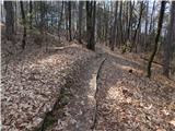 9
9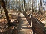 10
10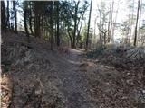 11
11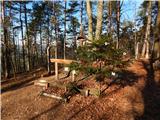 12
12
Discussion about the trip Ljubljana (Podgorica pri Črnučah) - Oljska gora
|
| Todi31. 01. 2018 |
My home peak, 5m from the start of the trail, 
Thanks Tadej for visiting my neck of the woods too.
|
|
|
|
| Tadej31. 01. 2018 |
You're welcome. It's a pleasure to discover places and residents of our beautiful Slovenia. If the descriptions are useful to anyone, all the better.
|
|
|
|
| Zvonček1. 02. 2018 |
Tadej, your descriptions are always very useful. I especially look forward to each new one.
Best regards
|
|
|
|
| rs565. 02. 2018 |
Excellent, there is space for parking
|
|
|
|
| cico8. 02. 2018 |
Why are those concrete posts for the wire
fence  ?? Spring, army, hunters??? ?? Spring, army, hunters???
Best regards!
|
|
|
|
| Todi8. 02. 2018 |
Cico, once there was a barracks and air defense of Ljubljana here, later after '91 a radar for air traffic control was installed. Which was supposed to be on Menina planina, ... now even the radar is gone. There are two peaks, one is still fenced and passage is not allowed. This other part is open and we locals use it for daily walks.
|
|
|
|
| cico8. 02. 2018 |
You were quick, thanks! If anyone is bored in this gloomy
weather, they should go see two
unfinished but fascinating underground
systems in the Cirje hill near Podlipoglava, under
the village of Javor, Google knows a lot about it, but Ljubljanans know little Good luck!
|
|
|
|
| cukrka18. 03. 2019 |
Hi Todi,
I suggest you correct the name to "Oljska gora",
as this hill is actually called by the locals
And I add that on this hill, which is suitable for walking, cycling and running, there are many such visitors who forget to take the trash back with them
Well, the stamp that was voluntarily bought to encourage kids from nearby villages to spend their free time in sports, unfortunately someone stole it 
Good luck
|
|
|
|
| Todi19. 03. 2019 |
cukrka, yes that's right, I'll write to the administrator to fix it.
|
|
|
|
| Tadej19. 03. 2019 |
I've fixed it. Best, Tadej
|
|
|
To post a comment you must log in:
If you do not yet have a username, you must first
register.