Starting point: Mače (586 m)
| Latitude/Longitude: | 46,31310°N 14,41870°E |
| |
Walking time: 4 h
Difficulty: difficult marked way
Elevation gain: 1546 m
Elevation difference along the route: 1550 m
Map: Karavanke - osrednji del 1:50.000
Recommended equipment (summer):
Recommended equipment (winter): ice axe, crampons
Views: 113.344
 | 4 people like this post |
Access to starting point:
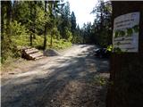
a) From the Ljubljana-Jesenice motorway take the Kranj-east exit, then continue driving towards Jezersko. When arriving in Preddvor leave the main road and continue left towards the centre of the mentioned place, from there follow the signs for Mače. When arriving in Mače, at the marked junction continue right (left Bašelj, straight church of St. Nicholas (church not accessible by car)) and drive up the narrow road above the village, where there is a larger marked parking lot.
b) From the Jesenice-Ljubljana motorway take the Kranj-west exit and in the first junction continue left. Continue driving through the underpass under the motorway, then arrive at the roundabout, from which continue driving towards Golnik. The road ahead leads through the settlement Mlaka pri Kranju, we at the end of the settlement continue right towards the settlement Srakovlje. Follows driving through Srakovlje, Spodnja Bela, Srednja Bela to Zgornja Bela, where continue right towards Preddvor. In Preddvor notice signs for Mače, which direct us left past the primary school to the road that ascends to Mače. When arriving in Mače, at the marked junction continue right (left Bašelj, straight church of St. Nicholas (church not accessible by car)) and drive up the narrow road above the village, where there is a larger marked parking lot.
Route description:
From the parking lot we return a few dozen steps back, i.e. to the road from which we drove to the parking lot and continue uphill along it towards Dom na Kališču and Storžič. We walk along the road for less than half an hour, then at Studenci the path forks.
We choose the left path, next to which there are signs for Kališče (right Srednji vrh), where we cross the stream, then immediately start steep ascent. A few minutes higher we reach a cart track, which we also immediately leave and continue following the markers. We continue on the marked path that continues between two cart tracks, higher up we ascend moderately in switchbacks for some time. Higher we reach the cart track again, follow it uphill, after a minute leave it and head to the marked path that brings us in a few minutes of further ascent to a rest area and viewpoint with a bench.
The path ahead returns to the forest and initially ascends gently, the easy walk ends quickly as after crossing the cart track we start ascending in switchbacks through the forest again.
Here, even before we start the steep ascent, the path from Bašelj joins from the left, we then ascend in switchbacks on the steeper slope, where we cross the cart track several times, all the time following the markers. Higher we occasionally get a nice view towards Gorenjska, followed by a somewhat longer traverse ascent to the right. Later, at an altitude of about 1330 m, the path turns left and ascends to the left with the exception of a few switchbacks. When we leave the forest we already arrive at the edge of Planina Kališče, a little further to the junction at Spodnje Kališče, where there are some benches for rest.
When above Spodnje Kališče the path returns to the forest, the path from Lašak (also path from Bašelj past Partizanska bolnica Košuta) joins from the left. Follows a few more minutes of walking through the forest and we arrive at a nice viewpoint, from which opens a nice view towards the nearby Dom na Kališču, Mali Grintovec, Lanež ridge, Krvavec... From the viewpoint only a short ascent remains and we are at Dom na Kališču.
Behind Dom na Kališču we notice a mountaineering direction sign with numerous route continuation options. We continue on the gentle and scenic ridge path towards Storžič, Bašeljski vrh..., which continues northwards. After a few minutes of easy walking with beautiful views reaching all the way to the Julian Alps, we arrive at a junction, where to the left branches the path towards the church of St. Lovrenc above Bašelj, Planina Javornik and Kriška gora, to the right branches the path to Bašeljski vrh and Mali Grintovec, we continue straight towards Storžič. Follows a few-minute traverse mostly of the western slopes of Bašeljski vrh, then we arrive at the grassy Bašeljski preval, where the path from Jezersko joins from the right (in descriptions starting point Jekarica).
Again we continue straight towards Storžič, this time on the path that starts steeply ascending through the belt of dwarf pines. After approximately 30 minutes of ascent from the saddle we step onto the Storžič ridge, which we soon leave, as the path passes to the southern slopes of the mountain. Over quite steep southern slopes we ascend on a steep path that is dangerous for slipping in several places, especially when wet. Higher the path levels somewhat and returns to the ridge, along and beside which it then continues. To the increasingly scenic path a little below the summit from the left also join paths from sv. Lovrenc, Planina Javornik and the path over Psica and through Žrelo. Here we continue slightly right and in a few steps reach one of the most visited two-thousanders in Slovenia.
Starting point - Studenci 0:25, Studenci - za Goro 0:40, za Goro - Spodnje Kališče 1:10, Spodnje Kališče - Dom na Kališču 0:15, Dom na Kališču - razpotje na Kališčem 0:10, razpotje nad Kališčem - Bašeljski preval 0:10, Bašeljski preval - Storžič 1:10.

Photos:
 1
1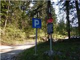 2
2 3
3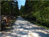 4
4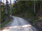 5
5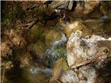 6
6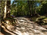 7
7 8
8 9
9 10
10 11
11 12
12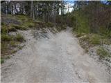 13
13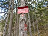 14
14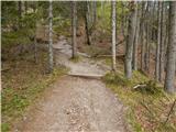 15
15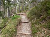 16
16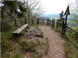 17
17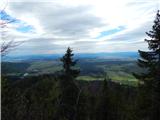 18
18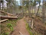 19
19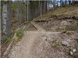 20
20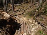 21
21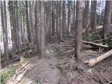 22
22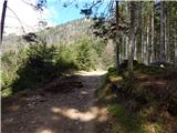 23
23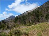 24
24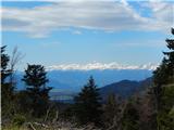 25
25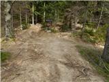 26
26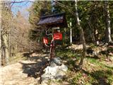 27
27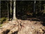 28
28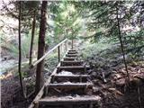 29
29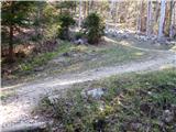 30
30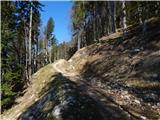 31
31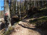 32
32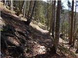 33
33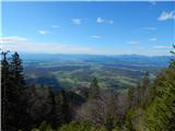 34
34 35
35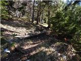 36
36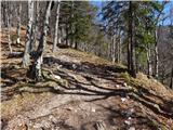 37
37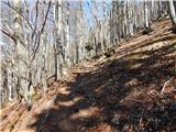 38
38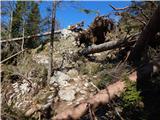 39
39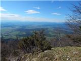 40
40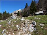 41
41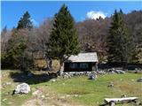 42
42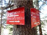 43
43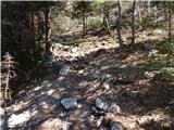 44
44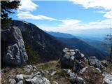 45
45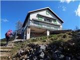 46
46 47
47 48
48 49
49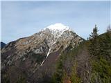 50
50 51
51 52
52 53
53 54
54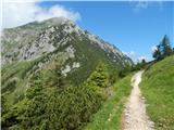 55
55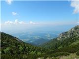 56
56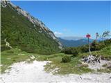 57
57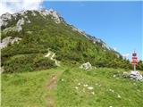 58
58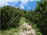 59
59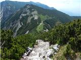 60
60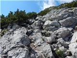 61
61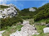 62
62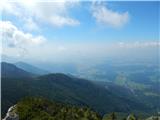 63
63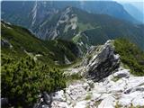 64
64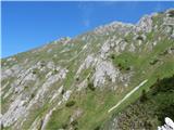 65
65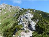 66
66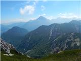 67
67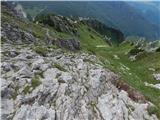 68
68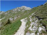 69
69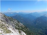 70
70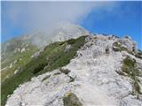 71
71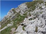 72
72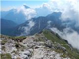 73
73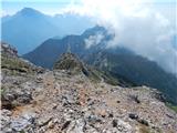 74
74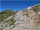 75
75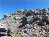 76
76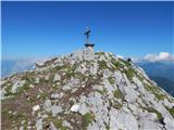 77
77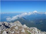 78
78 79
79
Discussion about the trip Mače - Storžič
Show older messages
|
| Gost13. 09. 2007 |
Brane V.-today was on Storžič, but my path is not described anywhere. It starts from the village Gojzd which we reach from Križ. Leave the vehicle at the church in the village. Above the village, the signpost directs us to Storžič. The path takes four hours. We go over Ježa, past Mala and Velika Poljana towards Storžič. Soon above the pasture, the signpost directs to Storžič over Psica - very demanding path. I went right over Graben. Through grassy meadows we go, almost straight up to Storžič. No dangerous path, just a bit strenuous. Worth trying this approach to the beautiful mountain Storžič.
|
|
|
|
| pohodnica5312. 11. 2008 |
Storžič really tempts me, but unfortunately I have quite a bit of vertigo. This year I went to Bašeljsko sedlo, then panic when I looked up, we went... back home. The summit still calls me and temptingly invites me, of course not now when the weather is bad, but I would be very happy if the "guest" confirms that his path is not at all dangerous for slipping. Example: I can't manage to Kamniška vrh via the steep path: would it work via Graben or is there another safe path to this beautiful summit? Thanks
|
|
|
|
| Kriška12. 11. 2008 |
I think this very path described above is the least dangerous and exposed. From afar it looks worse than it really is!
If vertigo bothers you, there are some ways to overcome it:
The simplest is, at places that seem exposed to you, don't look around, but at the path under your feet. That certainly doesn't cause vertigo.
If the vertigo problem is more serious, I definitely recommend a check-up with an ENT specialist, you might have issues with the balance organ that can be resolved with appropriate therapy.
Sometimes even taking a dietary supplement (Bilobil) over a longer period helps a little, and maybe some Persen before starting the hike, and you'll definitely manage this path.
Everything listed above checked and from first hand!
|
|
|
|
| fpetel113. 11. 2008 |
From the Javornik pasture and past Krničarjeva koča it is definitely a less exposed and precipitous path - as a beginner I prefer that one.
But for descent it is quite unpleasant and steep. Otherwise all approaches in the high mountains are potentially dangerous (even with the worst challenge) This path is in snow and wet easily very dangerous - even for 'experienced' hikers!
|
|
|
|
| žl13. 11. 2008 |
Kriška's advice regarding Bilobil and Persen is just advertising for the company and should not be taken seriously. From the Javornik pasture, with an experienced hiker and trust in him, roped up on prusik, try as far as it goes. It's worth the effort. On Monday I was on Storžič, a beautiful sunny day. In the valley, a sea of fog.
|
|
|
|
| serajko13. 11. 2008 |
pohodnica53
For this year the approach from Javornik pasture is already too late. I agree with fpetl1 that every high path is potentially dangerous. This one to Storžič
is nasty in wet and icy conditions, otherwise it is suitable even for those with vertigo, as there is no dangerous passage where you could easily fall over rocks. The whole path mostly follows a built path over grassy terrain and along the bottom of the gully. Only the last 20-30 minutes is a bit more "exposed". I think with proper encouragement or in weather with a bit of fog she wouldn't have any problems. I myself have been to the summit via this path even with two children 5-7 years old without any special issues and without ropes.
|
|
|
|
| Kriška13. 11. 2008 |
žl - I had no intention of doing any advertising, but only offered advice that partially eased my problems for me (until I started taking medication as prescribed by the otorhinolaryngologist). If someone has prejudices against natural remedies in capsules (or against certain companies that produce them - I don't even know which ones they are), of course you can also drink teas from the same plants (in the above case crushed ginkgo biloba leaves and some tea mixture of valerian, hops, lemon balm), it's just a bit more time-consuming and harder to dose.
In any case, I fully understand pohodnica53, because I myself went through a longer period of exactly the same problems, when most healthy people couldn't understand at all that some paths were too dangerous for me and many diagnosed me with "shirking".
|
|
|
|
| pohodnica5313. 11. 2008 |
Thank you all sincerely for the good advice and encouragement. I will try it in spring when the time is really suitable; I can always turn back, right? But I hope the summit will be "mine too", because I've wanted it forever and that I can wave to you in greeting
|
|
|
|
| serajko13. 11. 2008 |
-----53
When the right time comes, let me know, I'll come to help!!!
|
|
|
|
| pohodnica5314. 11. 2008 |
with pleasure, I'll give for blueberries, if I reach the summit alive (well, and down too)
|
|
|
|
| mojcej'7221. 08. 2009 |
Yesterday I decided that today 21.8.2009 I won't go to work (took leave) and go to Storžič instead. The weather was sunny, personally too hot for me, but I endured with bottles of water. I left the village Mače at 8:50, arrived at Kališče at 10:20, had 20 min. break (as usual hung my t-shirt to dry on that wooden fence with the rest of the colorful spectrum that was already there) and then went knee-grinding in the heat up the slope of Storžič. At 12:20 I managed to stamp the transversal, but sadly found out that the logbook was full, some idiot even tore out a couple of pages! Then we all gathered at the top took pictures of each other with mobiles (for proof) and then still in the scorching sun I went back to Kališče (14:00), it seemed to me I drank all the water flowing from the tap behind the house there and then went into the forest (thinking it would be cooler). I crawled to the car, which I left in the parking lot, at 16:15 and thought I was really cool. The day was perfect for me.
|
|
|
|
| aleš4315. 10. 2009 |
To Kališče it took exactly 2 hours (with short breaks) as indicated on the signposts. To the summit I used 20 min more than stated, hm. The path is very steep, demanding, because it is slippery and crumbly, and snow patches (ice) hindered the ascent to the top and also the descent (and my age and kilos).
Otherwise nice view that day, north wind, fresh ... otherwise, wonderful, as always in the mountains.
|
|
|
|
| jprim15. 10. 2009 |
Come on, forget the years and kilos, I have too much of both.
|
|
|
|
| nata2420. 11. 2009 |
Maybe someone knows how the snow is on this trail, from afar it looks almost bare.
Regards, Nataša
|
|
|
|
| serajko20. 11. 2009 |
On the trail there are individual spots with trampled snow, frozen in the morning, softened during the day. No problem
|
|
|
|
| BACEK JON19. 05. 2010 |
On Sunday I plan to go to Storžič from the direction of Mače, although from the valley it looks fairly snow-free, I'm still interested in a bit more detailed information (best first-hand) about this path, THANKS.
|
|
|
|
| serajko19. 05. 2010 |
regards
Mače -Kališče- Storžič is snow-free except for a few "patches" that can be bypassed. Povlje -Karničarjeva -Storžič is passable partly over remaining snow. Need to be careful due to steep
sections and slippery ground
|
|
|
|
| BACEK JON20. 05. 2010 |
Thanks serajko, good luck on the trail and regards.
|
|
|
|
| gcsaba230. 08. 2010 |
Hmm a month ago I went in fog and it seems I took a wrong turn somewhere because it was much more demanding than it looks in the picture here. There were markings but also climbing without via ferrata...
|
|
|
|
| svizec61. 11. 2010 |
On Sat 30.10 conditions good for my taste. To Kališče via "right" path over Kozjek, longer and less visited than classic. From 1300m some south wet snow, luckily trodden. Otherwise orientation on trodden track to base of final ascent to Kališče hut tricky, esp in fog, few marks (wet/icy slip risk!). From hut no issues, but strong wind at saddle surprised (Storžič top foggy), ended at Bašeljski vrh via classic. Descent to car at Mače uneventful except slippery rocks. Nice autumn hike!!
|
|
|
|
| tinao11. 11. 2010 |
Early in the morning - still dark - Janko gets up and prepares for the hike to Kališče.
When he reaches the door, he notices it's raining heavily. A bit too much - he thinks, hesitates and finally decides to return to bed. As he slips into the dark and jumps under the blanket to his wife, she gently asks him:
...
Is it raining?
Yes, the husband replies.
She laughs: Ha, our fool is off to Kališe!
|
|
|
|
| navrhu13. 11. 2010 |
I have a lot of criticism against the path markers, as on 13.11.2010 I got lost on the way back from the hut towards Mače village, where I left the car and thus ended up in Bašelj village. Yes, they could try a bit harder especially with the frequency of markings. It doesn't help if they have "beautiful", but not continuous, hiking marks on some parts of the path, in between they are old and quite rare. One big minus for PD Kranj from my side!
It wasn't full fog, nor mist, and I see very well (don't wear glasses) and have quite a few mountains hiked in my life. When I realized I was no longer on the right path, I didn't feel like going back up the hill, but hoped there would be some junction to Mače somewhere, otherwise I'd go to Mače from Bašelj village (and so it was). I assumed these two villages are very close and they really were. PD Kranj should do its job properly, then this won't happen. In the picture, see what poorly visible markings you have, and even those are hard to find.
|
|
|
|
| alesh7413. 11. 2010 |
It's very good to have a map or a Garmin with you....
|
|
|
|
| serajko13. 11. 2010 |
Whoever in such weather as it was today and given the fact that many ascended this path in the morning gets lost, really has "bad luck" The crowd that was at Kališče today as well The crowd that was at Kališče today as well
(parking in Mače was 100% full at 9:30) would gladly help upon a friendly question!!
|
|
|
|
| brankobr14. 11. 2010 |
No problem if you get lost, I have gotten lost here twice on the way up. At the beginning of the gully you have to go left.
If you look alternately up and down, no problems
p.s
Storžič is the most beautiful mountain.
In winter it's nicely visible even from Novo mesto.
|
|
|
|
| jersy14. 11. 2010 |
At the top, I don't know how you managed that, the path to Kališče is so well-trodden that it's really hard to get lost. You probably went astray already at Planina Kališče, where there really are no signs, but the path is completely different from the one from Mače, so with sensible thinking you could have turned back. If you go downhill towards Mače, about halfway there's another path fork, which picture number 13 shows.
|
|
|
|
| navrhu14. 11. 2010 |
You are the ones who obviously often go to Kališče and further to Storžič and therefore don't look at the markings at all. And that is the weakness of local path markers; they know the paths too well and therefore think it's unnecessary to paint markings. That thinking is wrong.
And the place where I "got lost". It was about 30 minutes before the village of Mače on the path from Kališča. I came out of the forest onto a gravel road and followed it to a sharp right bend and immediately after that sharp right bend there is a marking on the left side that leads downhill into the forest and I was convinced that this marking was for Mače. I followed these markings, but there were no more of them. Then I came to two direction signs on the same tree, one pointing left to Bašelj-marked path and the other right to Bašelj-forest road. There I knew I was not on the right path.
If the signs on the road and in that sharp right bend were visible and with inscriptions where they lead, this wouldn't have happened.
So, you can comment as much as you want, especially those who know the path and don't look at the signs at all, but if it happened to me, it happened and it will happen to someone else.
With this writing, I just wanted to point out the deficiency of the mountain markings for Storžič and Kališče and encourage the markers to repair and supplement the markings.
|
|
|
|
| navrhu14. 11. 2010 |
Check the condition of the markings leading from Mače to Storžič on the "Forum" and then select "Kamniško Savinjske alpe" and then "Storžič". There I posted a photo of the marking and you won't find better than these (except on individual kitschy mountain signs).
|
|
|
|
| Lunca12. 07. 2011 |
Last week my aunt and I were on Storžič... during the descent she fell and got injured. I would like to thank the female hiker who, after the fall, walked the path to Kališče with us, especially for the encouraging words to me that everything would be okay.. And it was... Aunt was reborn. But just thinking about how it could have ended... And a warning to everyone... Storžič is not for everyone... And what angered me the most was when, even before the fall, we were returning back in the fog where you could hardly see in front of you, and we met three older hikers, a gentleman and two ladies.. And I kindly told them it wasn't for going to the summit. And the gentleman gruffly said to me: if we've come this far, we'll go to the summit too! And that's why there are so many accidents... Aunt is an experienced hiker, 40 years in the mountains, and she fell...
|
|
|
|
| redbull2. 03. 2012 |
hi
I'm interested in this trail to Storžič, if it's passable now when there's a bit more snow or if there are any problems, let someone write if anyone started from Mače.
thanks dejan
|
|
|
|
| pohodnik3830. 03. 2012 |
On Wednesday 28.3. I walked this trail and must praise how exemplary it is maintained and marked, otherwise no special features. Trail without special features, just occasionally some patch of ice appears where caution is needed... some photos at this link.
|
|
|
|
| Branee6. 04. 2012 |
I was up there this year too (27.3) it's a nice hike for building fitness, just some overdo it with poles there over the rocks towards the top
Anyway 27.3 it was great and dry, just windy quite a bit so the stop at the top was shorter, that's why the return to the pub at Kališču was that much longer
|
|
|
|
| Janiel7415. 06. 2012 |
Today took advantage of another beautiful Friday (vacation) . Storžič in all its glory, sun, very little wind... at the hut on Kališče I got the largest portion of pasta in my life Ate very hungrily for half an hour.
|
|
|
|
| soraya17. 08. 2012 |
Could someone please write if this summit is suitable for me - I'm a bit afraid of exposed sections. Wires, pegs, brackets... I like to see all that. But I've already been to Nanos, Brana, Planjava, Ledinski vrh, from the hut at Ledine to Češka koča through the gully.... and more could be found... and I had no problems.
|
|
|
|
| juhejnaprej17. 08. 2012 |
Soraya, if you go from Povelje, there won't be any problem with exposed sections - there are none there. Given that you've already been to Brana and Planjava, I think there won't be a problem with any other route to the summit either. The only one that's a bit more exposed is the one through the gully.
|
|
|
|
| soraya17. 08. 2012 |
Thanks a lot for the info, Juhejnaprej! What about Skuta? It tempts my friend, but I have a bit of respect for it.
|
|
|
|
| lepenatka17. 08. 2012 |
Almost every mountain has an easier and a harder approach, including Skuta.
For example, from Kokrsko sedlo past the bivouac under Grintovec under Dolgi hrbet is the easiest approach to Skuta. It does drag on a bit, but there are no really difficult sections. You already have some experience. The route is well described if you click on Skuta.
|
|
|
|
| soraya17. 08. 2012 |
Thanks, Lepenatka. Have a nice day!
|
|
|
|
| Potohodnik12. 09. 2014 |
Storžič is a mountain where from any direction you need decent fitness and it's not really easy from anywhere. This path deserves the label demanding marked. Carefully, so we don't slip on the steep grass.
|
|
|
|
| joža x14. 09. 2014 |
Depends, how for whom, for me a few years ago this path seemed like a longer walk, if I went today...?. We can't judge path ratings by ourselves
|
|
|
|
| Barentoter25. 02. 2015 |
This weekend I'm heading to Storžič. What are the snow conditions like after the last snowfall? Is the road to Mače or the parking lot passable? Thanks and light steps.
|
|
|
|
| pikica125. 02. 2015 |
The parking lot is always plowed and maintained, you won't have issues with the road there either. When I parked there a month ago, my car was broken into. He didn't take anything, as there was nothing. But he smashed the car radio, intentional damage, of course.
It happened to me for the first time, although I've parked there many times. So don't leave anything in the car that's dear to your heart
|
|
|
|
| Barentoter25. 02. 2015 |
Thanks for the information. Break-ins are really increasing. A worrying fact, especially since hikers are supposed to be honest people.
|
|
|
|
| pikica125. 02. 2015 |
Hikers don't do that, they come to the parking just for that purpose. They know there are always plenty of cars, they check them, sometimes find something they like. This happens multiple times at these mountain parkings. Krma is also targeted often.
Regards.
|
|
|
|
| ljubitelj gora25. 02. 2015 |
The parking lot is located right above the last houses. Don't leave valuables in the car.
|
|
|
|
| Branee25. 02. 2015 |
but let me say that the parking in Potocah is not safe either. They also broke into my car and took about 600 euros in cash. They also emptied the coins that were in the ashtray.
|
|
|
|
| nordkap25. 02. 2015 |
It looks like nowhere in this world is safe anymore.
We'll have to walk around with a bus or something.
If I catch him, I'll break both his arms.
I'm wondering how you Brane manage to have 600€ cash in the car, I've never had that much on me in my life, let alone in the car.
In mine they can take some wiper blades and long-nose pliers.
It's true though that then you only have crap with repairs if they break something and proving it to the insurance etc...
|
|
|
|
| Viper25. 02. 2015 |
Well, they haven't broken into my car yet, and I go to Kališče often. But if I catch him during the break-in, he'll be in pretty bad shape. The problem is you can't just catch such people in the act. Obviously they have luck.
|
|
|
|
| Branee25. 02. 2015 |
There are quite a few of them in the Preddvor area. Just last year a criminalist told me over 20. And they go in groups of 2-3 to watch each other's backs..
|
|
|
|
| pikica125. 02. 2015 |
What a shame, because this is happening, I used to like coming to this area. Storžič in winter is a nice hike. And from Cjajnovce along the ridge to Bašeljski vrh is also nice, hardly meet any people.
Now it's put me off a bit. I sniffed around the car at home, felt like I could smell another person inside  More than the broken radio, it bothered me that someone was in my car More than the broken radio, it bothered me that someone was in my car 
Brane you're also some kind of weirdo.
|
|
|
|
| nordkap26. 02. 2015 |
It's interesting that there are so many in that area that the criminalist told you, but did he tell you how many they've caught, probably "null point Josef", because they're incompetent or don't bother with such things.
So there's some gang operating in the Gorenjska end, and the devil's not so black that they won't get caught once. Everything gets caught if you want to.
Pikica, but when you sniffed a bit it didn't smell like another person, ha ha
|
|
|
|
| pikica126. 02. 2015 |
@nordkap, read that as unknown
There's a notice at the parking lot not to leave anything in the car because of theft.
|
|
|
|
| nordkap26. 02. 2015 |
Yeah, yeah, sure, every excuse is good, right?
What it says is written everywhere on parking lots anyway, and even if it's not, I never take anything unnecessary or conspicuous with me or leave it in the car.
I really don't know what drives such people to do it, except making damage, since they can't take anything valuable anyway.
I don't know what I'd look for in the car to take, except of course if you don't have a visible map on the windshield or on the glasses showing where you have hidden € in the car.
But it's a pain if they really smash something on purpose just because you have crap.
Well, we live in such times.
|
|
|
|
| subaru26. 02. 2015 |
Yeah, that's the biggest crap - they practically get nothing, but the damage is quickly 500 eur +.
They once took out all the airbags from a friend's car at Jermanci.
|
|
|
|
| Planinec429. 03. 2015 |
Hi. How is the path from Mače to Storžič? Namely, I plan to go this week. What is the difficulty like in winter time (mandatory equipment etc.).
Thanks for the reply!
Best regards, planinec4
|
|
|
|
| Zgembo9. 05. 2015 |
I was on this tour today, there's not even a trace of snow
|
|
|
|
| tjas_a5. 08. 2015 |
hi, on Saturday we plan to conquer storžič. so we don't look at it from the terrace all our lives, which path do you most recommend for us who are just more beginners at conquering peaks.
thanks for the answer
|
|
|
|
| Branee5. 08. 2015 |
For someone who has no experience with hills, I would suggest the path from the village of Lasko
|
|
|
|
| jax6. 08. 2015 |
The one described here is also quite a good option. Up there it's occasionally steep, but the path is so well-trodden that there really shouldn't be problems, unless you already know in advance that someone might have severe vertigo issues.
The absolute easiest approach is from Povelj through Javorniško grapo, where it's actually a trail through grasses right to the top. But that path is personally less appealing to me, because it's monotonous, the grasses also require caution, and besides, the gully is exposed to avalanches, so the path might be damaged. Therefore I would almost advise you the path past Kališča (either from Mače or from Laškega, in Laško you can drive a bit higher), although it's a bit harder up there.
|
|
|
|
| ljubitelj gora29. 11. 2015 |
Picture 41, where the hiker is, there is now a fixed rope.
|
|
|
|
| Domch1. 12. 2015 |
There are 3 fixed ropes. The first for crossing and then two upwards on that rocky ascent, they make it easier, especially on descent.
|
|
|
|
| istrumel10. 12. 2015 |
what are the conditions like on this path?
|
|
|
|
| mlubej12. 12. 2015 |
Dry to Bašeljski preval, then ice on the path. Two girls wore small crampons, the rest clung to the bushes
|
|
|
|
| istrumel13. 12. 2015 |
thanks, I was at Kališče today and they said it's icy. but still a nice trip in spring-like conditions.
|
|
|
|
| Pekana5. 04. 2020 |
Heheheh, what do you say, smoking foxes?! The two of us with my girl to Storžič, at Mače parking already full, so we parked at Kališče for free. I say to Majda, this crisis won't last forever... Šuškovc, mommy, mask, backpack, done! But I forgot the sanitary wipes at home in the backpack.. She says, "damn rooster, the last day before it gets quarantined! You'll go in your underwear, I'm not waiting for you to get wipes".. I say okay and we go!
Majda dressed in the latest mountaineer fashion and me in underwear and long johns and backpack in hands. We flew up, folks in masks seeing us ran away from us, I say, that's the law! No backpack so I took an empty one from the car, put my girl's stuff in it... It'll be like that on Saturday, where there will be fireworks smoke in the air, but it doesn't bother us much. I say ours, inhaling smoke she hasn't seen for so long  . Hey, you know western Sahara, I ask... right? I say mine is lower than Morocco. . Hey, you know western Sahara, I ask... right? I say mine is lower than Morocco.
Well when we reach Kališče, oh we lay down, up there plenty of people, chatting one with another, screw the virus. Some plumbers talking right close, saying to each other "you know I fixed a faucet a couple days ago and piped water sloppily". I say cash in hand is best... and they started laughing, we with Majda too. We rested down in a hollow near the ridge, the sun warmed our already plenty warm souls. Madonna I was shocked... every morsel touches you as if sticking in your mouth, it tasted like Kranjska klobasa! Majda says, since you haven't seen smokers you haven't seen Storžič today either, it was too flat. You see I say! Majda says, since you haven't seen smokers you haven't seen Storžič today either, it was too flat. You see I say!
Trail for all those interested, mostly dry, snow in the last 100m elevation, wheels on the trail just like pig tracks, otherwise no need for caution, I mean to Kališče, to Storžič you need crampons don't kid...
Well, we then sunbathed for 2 hours... going down chatting, and my dear who forgot what she drank at Bohinj last weekend, so she doesn't remember where. I say she forgot weekends as she forgot everything.. Hey you Petr, that's how it is!
To Velika planina really long is the way, with dog paws it covers in trot, on big I have son on small daughter, both I'll make on Saturday evening.. this going down I hummed a piece in my head...
Oh pics in mask I also posted on my profile, check!!
Take care
|
|
|
|
| hočo5. 04. 2020 |
Nicely brightened the day
|
|
|
|
| skalar506. 04. 2020 |
and what is this "Pekana" supposed to be? humorous, current Gorenjska/hill dialect record, "appropriately" spiced words? ... ahh ...
|
|
|
|
| Pekana7. 04. 2020 |
Skala50, go take a pic of some fat guy with pink and post it, that's more suitable for anyone than my notes.
|
|
|
|
| Lenuh9412. 04. 2020 |
Regarding the burglaries in Mačah and Potočah. The worst is that everyone knows who does it, helped by his mother and grandmother. Once they caught him, tied him to a tree, poured gasoline on him (without lighting it)
In Mačah someone caught him once and chased him away, and he just went to the neighboring house to steal further
|
|
|
|
| glorija29. 05. 2021 16:57:06 |
28.5.2021 Great day ..just a few steps on snow, otherwise all dry....
At Kališče homemade top-notch štruklji, work of the diligent hands of the caretaker... Safe steps and bon appétit to all!
|
|
|
To post a comment you must log in:
If you do not yet have a username, you must first
register.