Mali Lipovec - Japetić (Across Velika livada)
Starting point: Mali Lipovec (385 m)
Route name: Across Velika livada
Walking time: 1 h 15 min
Difficulty: easy marked way
Elevation gain: 494 m
Elevation difference along the route: 494 m
Map:
Recommended equipment (summer):
Recommended equipment (winter):
Views: 2.706
 | 2 people like this post |
Access to starting point:
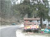
We arrive in Croatia via the Brežice / Bregana border crossing. On the Bregana-Zagreb motorway drive to the Samobor exit. In the town follow the signs for Rude and Jastrebarsko. When you see the right turnoff for Smerovišće, leave the main road and continue to the village of Mali Lipovec (15 minutes) and the Šoićeva hiža restaurant, where you can park (if the parking lot is full, park further along the road and in any case it is recommended to park along the road, as the parking lot is intended for restaurant guests).
Route description:
From the Šoićeva hiža restaurant we head west, but only to the first intersection in the village of Mali Lipovec, where we take the right asphalt road (there is also a cart track that is an unofficial shortcut). The road quickly and steeply ascends through the village and brings us to the forest entrance. Here at the bend we turn sharply right west. The cart track will be steep at the beginning, but the steepness will gradually ease and the path will soon level out. The level path brings us to the Velika livada meadow.
Once this was a lively alpine pasture, today it is unfortunately abandoned and increasingly overgrown. There is also a junction where the path to the Lovnik summit and the Sveti Bernard mountain hut branches off.
We continue ahead and enter the forest. The path will gradually become steeper and in the second part also more slippery and rocky.
When the path finally levels out, it continues along a wider and often muddy forest cart track. Further on, strips of sparse forest alternate with strips of dense and dark pine forest. After that the level cart track rises slightly and brings us to an asphalt road. Here is another junction where paths from northern starting points as well as the path from Žumberak/Gorjanci join.
Along the road we continue left, but only two minutes, then continue left into the forest. A short strip of dense forest follows after which we reach a junction where the path from Ivančičev and the variant across Velika vrata also join. Here we go right and after a short steep ascent we are at the top where there is a lookout tower (if we went left we would reach the Žitnica mountain hut in ten minutes).
At the top there is a lookout tower from which an exceptional view opens in all directions except the east. Under good conditions the Kamnik-Savinja Alps and Snežnik can also be seen.

Photos:
 1
1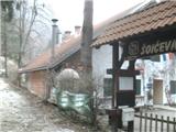 2
2 3
3 4
4 5
5 6
6 7
7 8
8 9
9 10
10 11
11 12
12 13
13 14
14 15
15 16
16 17
17 18
18 19
19 20
20 21
21 22
22 23
23 24
24 25
25 26
26 27
27 28
28 29
29 30
30 31
31 32
32 33
33 34
34 35
35
Discussion about the trip Mali Lipovec - Japetić (Across Velika livada)
|
| fpetel117. 04. 2016 |
Very pleasant path. At the beginning it can be hot due to the southern and sheltered position. The path despite the initially steeper part is not strenuous. We can listen to birdsong. Later the path becomes almost flat. For the path we need about an hour and a half of moderate walking.
|
|
|
To post a comment you must log in:
If you do not yet have a username, you must first
register.