Mangartska planina - Šober / Monte Sciober Grande (via Dren)
Starting point: Mangartska planina (1295 m)
| Latitude/Longitude: | 46,42900°N 13,61020°E |
| |
Route name: via Dren
Walking time: 2 h 35 min
Difficulty: easy unmarked way
Elevation gain: 550 m
Elevation difference along the route: 605 m
Map: Julijske Alpe - zahodni del 1:50.000
Recommended equipment (summer): helmet
Recommended equipment (winter): helmet, ice axe, crampons
Views: 969
 | 1 person like this post |
Access to starting point:
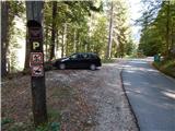
From the Bovec - Predel border crossing road, we turn onto the road in the direction of Mangartsko sedlo, along which we drive to the marked parking lot before Mangartska planina, where we park.
Route description:
From the starting point, we continue on the left road in the direction of Mangartska planina (if we continue straight we can reach Mangartsko sedlo) and after a short descent we cross a torrent bed, after which we reach the edge of the mountain pasture Mangartska planina and a junction.
From the junction, we go right (left planšarija) and follow the marked path towards Mangartsko sedlo. The path ahead leads us along an older abandoned road, but when we approach the scree fields that we notice on the left side, an older cart track branches off to the left, along which we continue. The path soon turns even more to the left and after a few steps brings us to a spot where a cairn usually stands. From the cairn we continue to the scree field, where a trackable but unmarked path appears, leading across Dren. Initially we ascend along the left edge of the scree field, and here and there the path goes a bit further left into a belt of dwarf pines or low forest. Higher up we reach scree fields a few more times, then the path transitions into more grassy terrain, where we gradually move to the right side of the small valley. Along the right side of the small valley we ascend to a spot where the path temporarily disappears, and continuing the ascent in the same direction is blocked by dwarf pines.
Here we go diagonally to the left, where the path reappears (if we continue straight or slightly right we reach the cliffs of Mala Ruša, over which an approach to the mentioned peak is possible), after a short ascent it levels out and transitions to the southwest slopes, across which we descend diagonally to the state border. This is followed by an easy ascent along a panoramic ridge, then on the saddle Čez stože we join the marked path that runs along the Stože scree.
From the saddle, from where a nice view of Šober opens up, we continue straight (left downhill to Mangartska planina along the marked path), crossing to the right, Italian side of the ridge. First we cross a fairly steep slope that is especially slippery when wet (the steep section can be bypassed by continuing along the lower path), then we mostly ascend diagonally below the walls of Vršič and the side peak Veliki Grintavec. The diagonal ascent ends at Vraška škrbina / La Portella, where we join the path from Rablj / Cave del Predil.
From Vraška škrbina we continue right in the direction of bivouac Cinque Punte, and the path ahead leads us along the very panoramic ridge of the Šober peak, from which a nice view opens towards Viš, Mangart, Jalovec and other surrounding mountains. The path along the ridge mostly ascends gently, only here and there descending temporarily a little. After about 30 minutes of ridge walking we reach the forepeak of Šober, from which we can already nicely see the cairn on the nearby main summit. From the forepeak a short descent follows, and once we are past the main summit, we continue right onto an unmarked path, along which in a minute of steep walking we ascend to the panoramic summit (the last meters are quite steep).
Starting point - Čez stože - 1:35, Čez stože - Vraška škrbina 0:25, Vraška škrbina - Šober 0:35.
Description and pictures refer to the condition in 2018 (September).

Along the route: Čez stože (1731m), Vraška škrbina / La portella (1798m)
Photos:
 1
1 2
2 3
3 4
4 5
5 6
6 7
7 8
8 9
9 10
10 11
11 12
12 13
13 14
14 15
15 16
16 17
17 18
18 19
19 20
20 21
21 22
22 23
23 24
24 25
25 26
26 27
27 28
28 29
29 30
30 31
31 32
32 33
33 34
34 35
35 36
36 37
37 38
38 39
39 40
40 41
41 42
42 43
43 44
44 45
45 46
46 47
47 48
48 49
49 50
50 51
51 52
52 53
53 54
54 55
55 56
56 57
57 58
58 59
59 60
60 61
61 62
62 63
63 64
64 65
65 66
66 67
67
Discussion about the trip Mangartska planina - Šober / Monte Sciober Grande (via Dren)
To post a comment you must log in:
If you do not yet have a username, you must first
register.