MHE Zali potok - Primožkovi hribi
Starting point: MHE Zali potok (799 m)
| Latitude/Longitude: | 46,40440°N 14,36850°E |
| |
Walking time: 1 h 30 min
Difficulty: easy unmarked way
Elevation gain: 527 m
Elevation difference along the route: 530 m
Map: Karavanke - osrednji del 1:50.000
Recommended equipment (summer):
Recommended equipment (winter): ice axe, crampons
Views: 502
 | 1 person like this post |
Access to starting point:
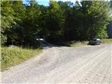
We drive to Tržič, then through the Dovžanova soteska gorge and Dolina we drive to Jelendol. In Jelendol at Born's manor we continue straight, then we drive on the main road to the next turn-off of the forest road to the left, which is situated next to MHE Zali potok. We park at an appropriate place by the crossroads.
Route description:
From the main road, we go over Tržiška Bistrica, then past the MHE facility we continue on a relatively steep forest road. The road further leads on the left side of Zali potok stream (right bank), a stream which higher up has two waterfalls.
Above the waterfalls, we arrive at a dam where we go sharply left onto a cart track which starts to ascend towards the west, at smaller junctions we continue straight. Higher, at roughly an equivalent junction of cart tracks we continue left, then in a few hairpin turns we ascend to a macadam road, where we go left again.
Further on, we walk on the road, which slowly turns to the right, so from the northern slopes we arrive at the southern slopes of Primožkovi hribi. A little further the road flattens out completely, at an appropriate spot we leave it and in a few steps ascend to the ridge. There follows a few minutes of walking to the highest point of the ridge, from where some views also open up.
The description refers to the situation in March 2020, and the pictures are from August 2017 and March 2020.

Photos:
 1
1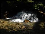 2
2 3
3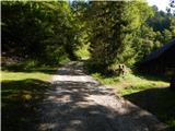 4
4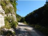 5
5 6
6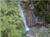 7
7 8
8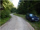 9
9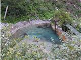 10
10 11
11 12
12 13
13 14
14 15
15 16
16 17
17 18
18 19
19 20
20 21
21 22
22 23
23 24
24 25
25 26
26 27
27 28
28 29
29 30
30 31
31 32
32 33
33 34
34 35
35
Discussion about the trip MHE Zali potok - Primožkovi hribi
To post a comment you must log in:
If you do not yet have a username, you must first
register.