Mislinja - Črepič (circular path)
Starting point: Mislinja (600 m)
| Latitude/Longitude: | 46,44270°N 15,19240°E |
| |
Route name: circular path
Walking time: 3 h 30 min
Difficulty: easy marked way
Elevation gain: 198 m
Elevation difference along the route: 300 m
Map: Pohorje 1:50.000
Recommended equipment (summer):
Recommended equipment (winter):
Views: 5.237
 | 1 person like this post |
Access to starting point:
From Velenje on the main road to Mislinja.
From Slovenj Gradec to Mislinja.
Route description:
Mislinja valley in Koroška, through which the river Mislinja is winding towards the northwest, offers a lot of options for hiking trips. On one side, Pohorje invites us with dark forests, bright meadows, and lonely homesteads, on the other side, Uršlja gora stirs longing with the highest church in Slovenia, no less attractive are walks in the lower surrounding hills. Circular path over Črepič, Fričev vrh, and Završe, managed by Planinsko društvo Mislinja, runs through diverse terrain south of the Mislinja valley. Because of the interesting landscape and wide view, walking there is attractive in all seasons.
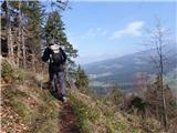
From the bus stop in the center of Mislinja, we go parallel with the main road towards the west. Flat cart track, which runs along the route of the former railway (the Velenje–Dravograd track was discontinued in 1969), closely follows the shaded foot of the forested Lučenca. After approximately twenty minutes of walking, we arrive at the hamlet Vovkarje, where we cross the torrent stream Mevlja. On the other side of the bridge, walking on flat ground ends for a while. In front of us is half an hour of relatively steep ascent, which in cold morning finally wakes and warms us up. A soft footpath covered with needles and leaves first slightly winds between high trunks, but quickly tires of that game and goes straight upwards. On a clearing covered with black hellebore, primroses, and common dogwood, we rest briefly, then continue onward. The steepness soon eases, the trees part, and an extensive meadow unfolds before us. Once, at its edge stood the homestead of farmer Črepinška, after whom Črepič is named, but today, an old wooden hayloft with stone foundations stands alone here.
Before continuing to the summit, hidden by trees, we quickly look around. To the west, we see the forested Fričev vrh, flanked by Peca and Uršlja gora. In the valley lie the settlements Dovže, Šmartno, and Slovenj Gradec, beyond which rise Rahtelov vrh and Selovec. Above the Dravska dolina, which we only sense, stands Košenjak. Golica behind it is already in Austria. The horizon to the north is closed by Pohorje with Kremžarjev vrh, Mala and Velika Kopa, and Črni vrh, while to the southeast stretches Paški Kozjak with Špik and Basališče.
From Črepič, where a metal box holds a logbook and stamp, we continue westward. The descent, in contrast to the ascent, is surprisingly short: before we fully realize, we are already among meadows. We join a macadam road winding past a chapel, turn right at the crossroads, and above the next homestead, we re-enter the forest. A soft path, becoming increasingly undulating, soon brings us to Časov vrh. From there, we descend to the saddle between the farms Fric and Levovnik, find a narrow footpath toward the summit, and climb the slope.
From Fričev vrh, with nearly half the path behind us, we continue across a scenic meadow to a crossroads of macadam roads. For the next few minutes we walk among trees, then the terrain opens again. In the distance, Smrekovec, Golte, and Posavsko hribovje appear, and to the north, we can slowly trace our gaze over Fričev vrh and Črepič. On the ridge and nearby slopes, scattered houses and farm buildings form the settlement Završe. The settlement was once called Šentvid nad Valdekom, indicating its connection to Valdek castle, of which only ruins remain. Završe boasts a school and two churches: the macadam road first leads to the one dedicated to St. Rupert, and after passing a hunting cottage and choosing the upper path at a crossroads, we reach the church of St. Vid. It is richly decorated inside. Particularly striking is the ceiling, where images of St. Hieronim, St. Ambrozij, St. Avguštin, and St. Gregorij are arranged around Kristus Kralj, while near the organ, St. Hema and St. Florijan are depicted. Below the church, we leave the Šaleško planinsko pot, which we joined before St. Rupert, and head diagonally downward. The cart track soon leads to a road, which we follow to a bend below a tennis court. There, we turn onto a sandy footpath among pines. Amid soft greenery, we descend unhurriedly to a solitary homestead at the foot of Lučenca. Now the circle is nearly complete: in a few minutes, the landscape around us will open, and Mislinja will reappear in the valley.
Length of the circular path (Mislinja – Črepič – Fričev vrh – Završe – Mislinja): three and a half hours
Path description and difficulty: The path is easy, with only the ascent to Črepič being somewhat steeper. We walk on well-marked forest footpaths, cart tracks, and macadam. In spring, many flowers bloom along the path, and we can also enjoy a beautiful view.

Photos:
 1
1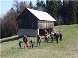 2
2
Discussion about the trip Mislinja - Črepič (circular path)
To post a comment you must log in:
If you do not yet have a username, you must first
register.