Mixnitz - Hochlantsch (via gorge Bärenschützklamm)
Starting point: Mixnitz (454 m)
| Latitude/Longitude: | 47,32920°N 15,36360°E |
| |
Route name: via gorge Bärenschützklamm
Walking time: 3 h 45 min
Difficulty: easy marked way
Elevation gain: 1268 m
Elevation difference along the route: 1268 m
Map:
Recommended equipment (summer): helmet
Recommended equipment (winter): helmet
Views: 12.384
 | 2 people like this post |
Access to starting point:
Mixnitz is located in the municipality of Pernegg an der Mur and we reach it from Graz (40 km from Graz) in the direction of Pernegg an der Mur. The exit is well marked, in the settlement Mixnitz we follow the signs BÄRENSCHUTZKLAMM.
Route description:
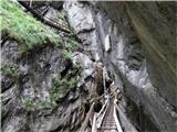
The path from the parking lot is well marked and after approx. 40 minutes of walking on a forest path we get to a smaller clearing, on which there is a "tollhouse". To the left of it leads the path through the forest towards the mountain hut "Zum guten Hirten", after which I recommend the return. At the tollhouse we pay 3.50 EUR entrance fee per adult and continue through the natural monument of Graz highlands, named Bärenschützklamm. We continue on approx. 290 stairs, 55 bridges, through the breathtaking gorge all the way to the mountain hut "Zum guten Hirten".
From here we continue on a well-marked path through a clearing, after a few hundred meters we come out of the forest on a macadam road, where we turn left, leave it after good 500 meters and continue on a forest path towards the summit. The path towards the summit turns right and ascends steeply through the forest.
Mixnitz - Bärenschützklamm 45 min, Bärenschützklamm - mountain hut Zum guten Hirten 1:30, Zum guten Hirten - Hochlantsch 1:30.
We can also shorten the tour and from the mountain hut return on a forest path to the starting point.

Photos:
 1
1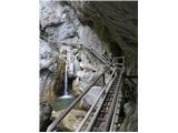 2
2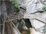 3
3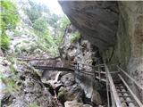 4
4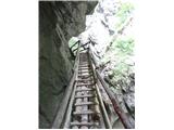 5
5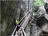 6
6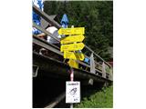 7
7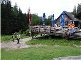 8
8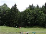 9
9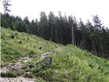 10
10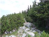 11
11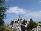 12
12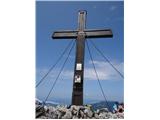 13
13
Discussion about the trip Mixnitz - Hochlantsch (via gorge Bärenschützklamm)
|
| KatjaB24. 07. 2017 |
Yesterday on excursion. To the hut where entrance fee is paid is 1.5 h demanding uphill walk. Then from hut to summit approx. 2 h. Need to overcome 115 bridges, 49 ladders and altogether 2900 steps not 290 as stated in description. Altogether approx. 3h, downhill path approx. 2h. Downhill path goes through forest path not steps because too dangerous. Excursion very demanding, I wouldn't take children there due to demanding ladder walking. Nor suitable for dogs. Otherwise the gorge absolutely worth seeing!!
|
|
|
|
| pro2c27. 07. 2018 |
Time indications on the signs will hold up. I'm not a very active hiker, but from the parking lot to the entrance hut for the gorge I took 40 min. It's a steeper slope and requires at least some fitness.
Through the gorge itself I needed more time, as one had to look at things. That took about 2h.
I agree about children and animals: the gorge is not suitable for small children at all.
Parking lot (450m) - Entrance to gorge (750m): 40min
Entrance to gorge (750m) - Guter Hirte (1200m): 1:30
|
|
|
|
| matejafh22. 08. 2018 |
Last weekend we went to Hochlantsch. It was wonderful, of course the gorge is especially interesting for children. We had ideal weather, only slightly bothered by the considerable crowd in the gorge. I like to enjoy nature and take photos, but through the gorge a whole crowd of people was streaming.
Definitely worth seeing, especially recommended for families with children.
At the top there is a logbook, but we didn't see a stamp, so my son was a bit disappointed , but the wonderful views from the top outweigh everything. , but the wonderful views from the top outweigh everything.
|
|
|
|
| Pajci_26. 07. 2022 18:57:15 |
This path no longer exists, due to bad weather everything is destroyed.
But go to the same starting point and then behind Guter Hirte and then further.
|
|
|
|
| Glogo27. 07. 2022 08:07:50 |
In 2020, a rockfall occurred in which 3 visitors died.
Since then, the path through the Bärenschützklamm gorge has been closed. Additional regulations have been introduced for reopening.
Renovation costs are estimated at around 650,000 euros.
Currently, it is not clear how the repair will be financed. Permanent closure of the path is also possible.
|
|
|
|
| Tadej28. 07. 2022 09:26:17 |
I added to the description that the path is closed until further notice.
|
|
|
|
| Jocy29. 10. 2024 10:03:15 |
The Bärenschützklamm gorge is open again since September 2024.
|
|
|
|
| Buha4. 05. 2025 12:52:57 |
We went yesterday through the Barenshutzklamm gorge to the top of Hochlantch, the gorge is open from May 1st, everything that was destroyed has been thoroughly renovated. Entrance fee to the gorge 9€ and the nearest parking also 9€ for the whole day.
|
|
|
To post a comment you must log in:
If you do not yet have a username, you must first
register.