Starting point: Mojstrana (720 m)
| Latitude/Longitude: | 46,45200°N 13,93600°E |
| |
Walking time: 2 h 20 min
Difficulty: easy marked way
Elevation gain: 873 m
Elevation difference along the route: 873 m
Map: TNP 1:50.000
Recommended equipment (summer):
Recommended equipment (winter): ice axe, crampons
Views: 75.439
 | 13 people like this post |
Access to starting point:
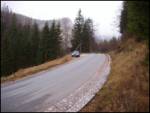
We leave Gorenjska highway at exit Hrušica and follow the road ahead in the direction of Kranjska Gora. Just a little before the village Dovje the road which goes to Mojstrana (Vrata, Kot and Krma) branches off to the left. We follow the road ahead in the direction of village Radovna and the valleys Krma and Kot. The relatively steep road then runs past the sign TNP, near which we park on a parking lot on the right side of the road (on the opposite side of the parking lot, we notice wooden signposts for Jerebikovec and Mežakla).
Route description:
From the parking lot, we cross the road and walk to the signposts, where the path to Jerebikovec begins. The path, which initially follows a cart track, enters the forest right at the start and ascends steeply up the slope. After two minutes of walking, there is a smaller junction, where we continue straight ahead (the right cart track gets lost in the forest). The cart track then turns into a steep footpath, which leads us along the northwestern slopes into an indistinct little valley between two side ridges of Jerebikovec. Through this valley, the path brings us to one of the side ridges of the aforementioned mountain, where there is a bench offering a well-deserved rest with a view of Kepa.
We continue to the right, first along the ridge, then the path switches to steep slopes up which we ascend. After an hour and a half of walking, the steepness suddenly disappears and the path brings us to another bench located at the monument to the fallen partisans on the mountain pasture Mežakla.
Here the path goes right and almost horizontally crosses the edge of the abandoned mountain pasture Mežakla. Just a little further on, we reach the road at Tilčev rovt. We follow this road for a good 5 minutes to the point where a signpost directs us right uphill into the slopes of Jerebikovec. The path ascends steeply again and brings us to a small ridge, where the steepness eases briefly. From the ridge, the path brings us back to the upper slopes of the aforementioned peak. After a few minutes, the path brings us back to the ridge, which we follow onwards. Further on, the path mostly runs a few meters below the ridge, which is covered in forest. A few meters below the summit, the forest ends and we see a small shack (emergency bivouac) on the top ahead of us.
Starting point - bench 45 minutes, bench - monument 50 minutes, monument - Jerebikovec 45 minutes.

Along the route: Planina Mežakla (1350m)
Photos:
 1
1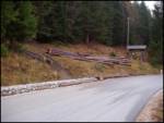 2
2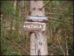 3
3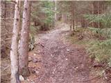 4
4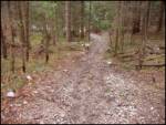 5
5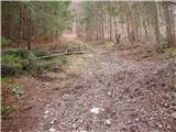 6
6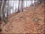 7
7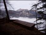 8
8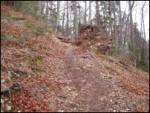 9
9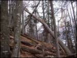 10
10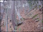 11
11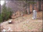 12
12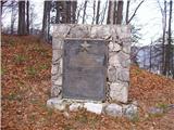 13
13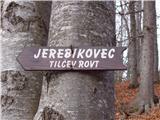 14
14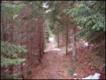 15
15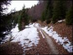 16
16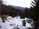 17
17 18
18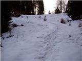 19
19 20
20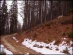 21
21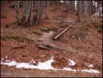 22
22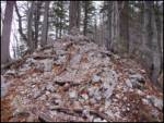 23
23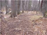 24
24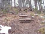 25
25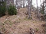 26
26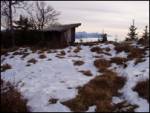 27
27 28
28
Discussion about the trip Mojstrana - Jerebikovec
Show older messages
|
| Gost10. 07. 2006 |
Beautiful excursion, even more beautiful view. Until you're at the top, you can't believe that such views open up from such a "hillock" in all directions. Pity that the book in the bivouac is no longer up-to-date with Žakelj's observations.
|
|
|
|
| Gost27. 07. 2006 |
Tough knee-grinder but the view repays all the effort!
|
|
|
|
| Gost1. 09. 2006 |
Recommended to everyone to visit Jerebikovec in good weather. Really nice view.
|
|
|
|
| Gost16. 12. 2006 |
When you go to Jerebikovec, at the top of the Mežeklja pasture (at Tilčev rovtu) turn right and along the marked route go to see the edge of Mežaklja, from where there is a view of Triglav, below it the Kot valley. Then to the top of Jerebikovec.
Local Miha
|
|
|
|
| Gost23. 07. 2007 |
One really can't believe that such views open up from such a "little hill". The path up is really steep, but once you reach the top you can forget all the hardships you've endured and meditate in peace, enjoying the magnificent views, provided the weather is nice.
|
|
|
|
| Gost23. 07. 2007 |
Oasis of peace and beauty. In all seasons.
|
|
|
|
| Gost20. 01. 2008 |
Since I know the summit is well visited even in poorer conditions, I'm interested how icy/slippery the path is? Thanks for info.
|
|
|
|
| Biser gora15. 03. 2008 |
Unfortunately, on Jerebikovec I didn't get the view because of fog. But due to the cold and windy weather, the bivouac came in handy. Since the path is very steep, I recommend poles
|
|
|
|
| Klin21. 03. 2008 |
My knees hurt too when I was climbing to Jerebikovec. But the view is such that I could talk about it for hours.
|
|
|
|
| FLEKSARCA25. 05. 2008 |
Today I took my little girl up there for the first time. Despite the really steep path at the end, enthusiasm, the view is unbeatable. Maybe just a tip, it's good to have some insect spray with you, because the flies had a meeting up there today.
|
|
|
|
| Stolar25. 06. 2008 |
Quite a suitable trip for a hot day, the forest provides pleasant shade. Only annoying insects bother, there are thousands of them at the top.
|
|
|
|
| heinz5. 12. 2008 |
Does anyone know if the path is trodden, e.g. for a trip this Sunday? (otherwise it's snowing again now)
Also; which easier (or slightly less easy) paths in the Julian Alps and Karawanks are in the winter period after snowfall first passable (without snowshoes or skis)? Just crampons.
I know of course someone has to be first, that it often snows in mountains in winter etc, but still it would be nice for some of us if the admin opened this topic..
|
|
|
|
| heinz6. 12. 2008 |
Great!
Best hiking portal on Slo. web!
Thanks!
|
|
|
|
| Skuta18. 02. 2009 |
REALLY hribi.net rocks!!
|
|
|
|
| birch19. 05. 2009 |
Been here in 2003 and without any fitness but I still managed the steep sections. Legs/knees really suffer (even more on the descent), but when you see the beautiful view, the effort is forgotten.
|
|
|
|
| darh13. 08. 2010 |
Last Sunday we also climbed to Jerebikovec for the first time via this described path. The view from the top is really wonderful, too bad only for some fog that started gathering around the Julian peaks. More about our impressions I wrote here.
|
|
|
|
| Parkeljc11. 12. 2010 |
Today I was up there, someone was there before the thaw and rain with snowshoes. The path is quite visible and mostly frozen, no point wasting words on markers. There are many small old snow avalanches on the path, which we easily cross. Below Tilčev rov the path is wind-blown, here even 4-point crampons would be useful (slip hazard).
From Tilčev rov towards the summit the snow is frozen, walking is not difficult.
To the summit I walked exactly 1 hour and a half, great views all around at the top. Returned the same way, descent 40 minutes.
|
|
|
|
| Maja_C12. 12. 2010 |
While pondering yesterday where to go today, I read Parkeljec's description, looked also in Mihelič's guidebook, where it says: "Friendly unknown mountain; don't postpone", and said to myself: "This is it for tomorrow". On the top in the company of snow-covered giants or on the bench in the bivouac. Under Tilčev rov really some caution was needed, from the bench downwards it was sinking just right for an enjoyable run back.
|
|
|
|
| avrikelj21. 02. 2011 |
On Saturday 29.2.2011 we conquered this "balcony of the Julians" with 34 hikers. From fog we came to sun, to fresh snow and at the top enjoyed really beautiful views. Highly recommend for a fitness tour! Before returning home we also visited the Alpine Museum.
|
|
|
|
| main22. 02. 2011 |
Avrikelj, your dates don't add up.
|
|
|
|
| Bojan_A19. 08. 2011 |
Today I was too tired for the mountains, so I went running up there. And I'm totally excited! The path is steep from the first to the last meter. In between there's 300 m of crappy unnecessary flat, but you endure it. Otherwise it's continuously nicely steep. So ideal for running. And shady all the way - so not hot. At the top reward - view of the Julian Alps. 43 min.
|
|
|
|
| mošt25. 08. 2011 |
I read in one guidebook that it's worth going up here when the rowan is red. Unfortunately, I didn't see a single rowan. Where does the name come from then?
|
|
|
|
| Breda20. 08. 2012 |
On Saturday, 18.8.2012, I was at Jerebikovec. From the Mojstrana - Krma road to the top, I needed 1 hour 40 minutes. The view is really nice, but the path is steep all the way. It is true that you are in the forest all the time, so the path is pleasant even in summer heat...
|
|
|
|
| ciklama20. 10. 2012 |
We used today's beautiful day to conquer Jerebikovec. Very interesting and very, very steep tour. The steepness doesn't relent all the way to the top and it really bites into your knees. But the summit is rather little visited, so there's peace in abundance. At the top you're richly rewarded for the effort, as the view opens to the Julijce and Karavanke. The valleys Krma, Kot and Vrata are lined up one beside the other, with Triglav reigning over the top of all three. Fantastic!
|
|
|
|
| klavdipo25. 01. 2013 |
Is the path trodden and what are the conditions now after this snowfall?
|
|
|
|
| Trobec26. 05. 2013 |
Nice hike. I'd just point out one thing...the description says marked trail. There are indeed 3 signs directing to the top, otherwise the trail is not marked (but easily followable).
|
|
|
|
| Bandzo15. 07. 2013 |
On Saturday we were at Jerebikovec and I have to admit that the path pleasantly surprised me. It is constantly steep, but nothing too difficult. Really nice for building fitness. The view in the fog was wonderful at the top!  I recommend the trip! Even if fog awaits you at the top I recommend the trip! Even if fog awaits you at the top
|
|
|
|
| pula6. 12. 2013 |
Does anyone know the current conditions on the path?

|
|
|
|
| Stane713. 12. 2013 |
The matter is especially from the bench onwards quite icy. Do not go up without at least small crampons.
|
|
|
|
| smolko18. 12. 2013 |
Conditions today still as described by Stane7
|
|
|
|
| capraibex11. 06. 2015 |
We visited Jerebikovec on Sunday starting from Mojstrana. The path is very steep but pleasant due to the shade provided by the forest all the way to the top. Well marked, no views, mists were swirling all day.
|
|
|
|
| katty24. 03. 2017 |
Today, when everything was swarming to Planica for the ski flying, I opted for Jerebikovec. The trail hasn't lost its steepness yet, but it has lost quite a bit of snow. The snow starts from the monument all the way to Tilčev rov t, continuing in some places all the way to the summit, which is partially covered with a snow base. Views wonderful despite cloudiness, only the sight of the bivouac is sad. It is completely collapsing (a section has already collapsed), but the new summit log notes that Mr. Žakelj plans to build a new one. The summit still isn't visited by many hikers, so it holds true that only few visitors tackle summits reached by steep trails. With the rustling of ptarmigans and the company of a small herd of chamois, the descent ends very quickly.
Despite the steepness, I definitely recommend visiting the summit, if nothing else for the views.
|
|
|
|
| aditaker28. 04. 2017 |
I'm wondering if there's also a stamp at the top, because we need it for a mountaineering booklet.?
|
|
|
|
| Anze14320. 07. 2017 |
Today a knife was found at the parking lot at the starting point. If anyone misses it, contact via email beny23@gmail.com.
There is a stamp at the top.
|
|
|
|
| Majdag23. 12. 2017 |
Thanks Ljubica, it's never too late.
|
|
|
|
| Lunca27. 03. 2018 |
Has anyone been to the top of the last clearing?
|
|
|
|
| J.P.31. 03. 2019 |
The path is nice, steep and there is only a bit of snow at the top and below the top at the bench. Winter gear not needed, just good hiking boots.
Regards
|
|
|
|
| Jusk22. 01. 2020 |
Steep path, but the view is super the path is initially dry and bare, a bit further from the bench in picture 9 snow starts to appear, which is really little, but just enough to make the path slippery, so be careful! At the top there were a few centimeters of snow. Lp
|
|
|
|
| Majdag8. 06. 2020 |
Sunday, 7.6. The path was mostly wet and slippery. At the top I briefly caught the mountain peaks, then fog covered them. Mists everywhere, that's nice too. Something is happening under the edge, maybe new bivouac. Met only one female runner. Below by the road meadow full of flowers, on the road lots of cyclists.
https://jelenkamenmajdag.blogspot.com/2020/06/jerebikovec-na-mezakli.html
|
|
|
|
| Jusk24. 10. 2020 |
After a long time I'm up there again, the path is still steep no special views today, fog and clouds everywhere around.. some light snow on pl. Mežakla and Tilčev rov t, nothing up the ridge, some snow patches on the top. The whole path is muddy and slippery.
|
|
|
|
| J.P.24. 02. 2021 |
Conditions are currently super. Snow starts almost on the road, at the top there's enough for a snowy idyll. Good winter boots were sufficient this time, crampons stayed in the backpack. On the way back the snow melts so quickly that the track is quite safe and descent fast. Regards
|
|
|
|
| tango20. 09. 2022 16:34:31 |
After a few years back at the top, the path is solid, not muddy at all, steep as always. Pleasant surprise at the top, as during our last visit the views were modest due to the increasingly tall spruces. Obviously some time ago, they cut down the trees that blocked the views towards Kukova špica, Dovški križ and all the way to Stenar, so the summit deserves its title as a first-class viewpoint again. Only the Karavanke remained more obscured. A really pleasant hike!
|
|
|
|
| bo_zl4. 03. 2023 21:34:03 |
Today first time on Jerebikovec. Views phenomenal. Quite some snow, in the last 15 minutes before the summit I made the first track, up to there a gentleman had trampled it who wasn't very talkative upon meeting. But I thought who it was, he's been to the top many times. Well at home Google confirms I was quite right in assuming who that gentleman L. is.
|
|
|
|
| J.P.20. 07. 2023 17:25:38 |
Copy paste from PZS: The hiking trail to Jerebikovec above Mojstrana is CLOSED due to storm damage🚧.
|
|
|
|
| diana.jug21. 10. 2024 11:47:05 |
Nice greeting.
I'm wondering if this path from Mojstrana to Jerebikovec is still closed?! Many thanks for the answer.
|
|
|
|
| turbo21. 10. 2024 17:44:51 |
It should still be closed, on the PZS path status map it says:
Selected section:
Na tnalu-Jerebikovec
Closed path section.
Date: 19. 07. 2023
Reason: Slo: Na planinski poti je več podrtih dreves. Do nadaljnjega je ta odsek neprehoden in zato ZAPRT. Eng: There are several fallen trees on the mountain path. Until further notice, this section is impassable and therefore CLOSED.
Mountain paths containing the selected section:
Mojstrana-Jerebikovec
Easy marked mountain path. The path has closed sections.
Walking time: 3 hours
https://stanje-poti.pzs.si/
|
|
|
|
| _tomy_3. 04. 2025 18:57:04 |
Today I checked the condition of the marked path from Mojstrana (720 m) and report that the path is completely impassable. It's not just a few fallen trees that could be crossed, but almost the entire slope has collapsed. Lp.
|
|
|
|
| jbs3. 04. 2025 22:34:51 |
Hm, where does Lojz go up then
|
|
|
|
| lynx13. 04. 2025 10:39:13 |
Besides the hunting paths from the south, which are probably still normally passable, this also applies to approaches from Mežakla. Everything is already snow-free.
|
|
|
To post a comment you must log in:
If you do not yet have a username, you must first
register.