Na razpotju - Koča na Klemenči jami
Starting point: Na razpotju (770 m)
| Latitude/Longitude: | 46,39200°N 14,62730°E |
| |
Walking time: 1 h 10 min
Difficulty: partly demanding marked way
Elevation gain: 438 m
Elevation difference along the route: 438 m
Map: Kamniške in Savinjkse Alpe 1:50.000
Recommended equipment (summer):
Recommended equipment (winter): ice axe, crampons
Views: 36.422
 | 3 people like this post |
Access to starting point:
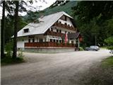
We drive to Luče (to here from Mozirje or over Kranjski rak) and continue towards Logarska dolina. Soon after the village Solčava we come to a crossroads, where the road branches off to the left to Logarska dolina. We turn left towards Logarska dolina (toll payment) and drive along the road to the signs for the Koča na Klemenči jami. We park on the parking lot near the pension Na razpotju. In front of the pension only guests are allowed to park.
Route description:
From the parking lot, we head onto the forest road in the direction of Klemenča jama. After a few minutes of walking a wide path branches off to the left towards Klemenča jama. We take this path, which starts to ascend. The quite steep path soon brings us to steep slopes, where with the help of the steel cable we cross a slightly exposed gully. The path, which continues ascending, soon brings us to the spot where a wall blocks the path. In front of us we see a cave and above it a marker that directs us into the cave. When we step into the cave we see that it is not a cave, but a nicely made tunnel through which we continue. In the tunnel the steel cable helps us, but we need it more on the descent than on the ascent. On the other side, along the wide path in a gentle ascent, we cross an exposed ledge. The path ahead goes into the forest and continues ascending on steep slopes, which are dangerous for slipping when wet. Further over a small bridge we cross another gully, then the path brings us to a less steep section, where the path from Dom Planincev joins. We continue gently uphill on the wide path, which soon brings us out of the forest. Only a short ascent on the grassy slope to the Koča na Klemenči jami follows.
From the hut we can continue to the thickest larch in Slovenia. We head left into the forest, where we follow the signs for the larch. To the larch we have less than ten minutes of walking through the forest.

Photos:
 1
1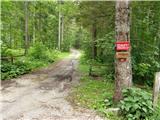 2
2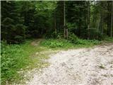 3
3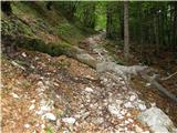 4
4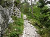 5
5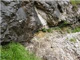 6
6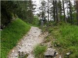 7
7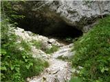 8
8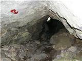 9
9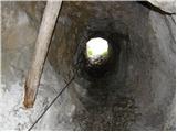 10
10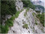 11
11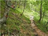 12
12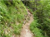 13
13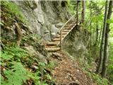 14
14 15
15 16
16 17
17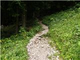 18
18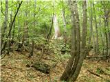 19
19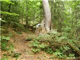 20
20
Discussion about the trip Na razpotju - Koča na Klemenči jami
|
| Gost30. 06. 2007 |
My husband and I were here in spring, we walked a bit longer, but I really liked the path - interesting and varied. From here we continued to Strelovec. I recommend the path when there is definitely no snow, we had to cross 2 fairly steep ones with not very nice exits (April).
|
|
|
|
| Gost1. 07. 2007 |
Nice path, I recommend extending it to Ojstrica as well.
|
|
|
|
| reina13. 10. 2008 |
Probably no one has been to Klemenči jama for a long time, judging by comments. But someone might show up to suggest or advise against going this weekend if weather allows.
Bold step to all! 
|
|
|
|
| Jany15. 10. 2008 |
There are two approaches to Koča na Klemenči jami. First from Razpotje and it is described in detail above, second from Dom planincev in Logarska dolina. Paths join 15 min before the hut.
Ascent to Klemenči jama and further to the largest larch is passable in any weather. Caution is definitely needed. Hut is now open only on weekends. Hostess bakes excellent strudel, host offers a variety of schnapps.
Hut is also a starting point for Strelovec, Krofička, Ojstrica, or circular path to Planina Icman.
Good luck, the weekend will be sunny!
|
|
|
|
| reina20. 10. 2008 |
Thanks 10c001. Unfortunately two factors postponed the trip to next time. First, I just couldn't  get to this portal where I always press for all instructions and such, my friend got sick already on Saturday, I was boiling for Sunday get to this portal where I always press for all instructions and such, my friend got sick already on Saturday, I was boiling for Sunday  . So we stayed in the foggy capital, hoping for next weekend bathed in sunshine. . So we stayed in the foggy capital, hoping for next weekend bathed in sunshine.
|
|
|
|
| joža x20. 10. 2008 |
The path that starts at the junction is definitely much nicer. I highly recommend the ascent to Krofička.
|
|
|
|
| Jany21. 10. 2008 |
Krofička is really nice and perhaps a bit neglected mountain and I definitely agree with Jože.
But at this time of year the "golden" larches at Strelovec are the most beautiful thing you must not miss.
|
|
|
|
| grdksmrt11. 08. 2012 |
Two days ago I visited the hut. We started from in front of the mountaineers' home and climbed to the hut at Klemenči jama in one hour. There a very friendly and obliging hut warden welcomed us. I would also praise the nice collection of local ''fiery waters'' that it offers shelter to.
I can certainly recommend a visit to everyone as the trail is easy and takes just over an hour. The view from in front of the hut is wonderful.
|
|
|
|
| BananaBronson18. 07. 2018 |
With almost four-year-old and one-year-old to Klemenčova jama, short report is here.
|
|
|
|
| daver18. 07. 2019 |
Is the path suitable for a dog?
|
|
|
|
| tomo_kugy18. 07. 2019 |
@daver
In principle, it shouldn't be a problem, only just before the path joins the one from Dom planincev, you need to go up a ladder (picture 14), so if he can manage that, you're good.
|
|
|
|
| Planinecizgg2. 01. 2020 |
Hello,
today 2.1.2019 I went up this path to Klemenči jama, and I must warn that the path is very icy. Without crampons and ice axe you can't get up safely. I recommend the path from in front of Dom planincev, since it's not icy there. Best regards.
|
|
|
To post a comment you must log in:
If you do not yet have a username, you must first
register.