Na Razpotju - Ojstrica (via Škarje)
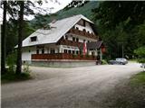
Starting point: Na Razpotju (770 m)
| Latitude/Longitude: | 46,39200°N 14,62730°E |
| |
Route name: via Škarje
Walking time: 4 h 15 min
Difficulty: difficult marked way
Elevation gain: 1580 m
Elevation difference along the route: 1590 m
Map: Kamniške in Savinjkse Alpe 1:50.000
Recommended equipment (summer): helmet
Recommended equipment (winter): helmet, ice axe, crampons
Views: 47.717
 | 2 people like this post |
Access to starting point:
We drive to Luče (to here from Mozirje or over Kranjski rak) and onwards towards Logarska dolina. Soon after the village Solčava we come to the crossroads, where the road to Logarska dolina branches off to the left. We turn left towards Logarska dolina (toll payment) and drive along the road to the signs for the mountain hut at Klemenča jama. We park on the parking lot near the guesthouse Na Razpotju. In front of the guesthouse only guests are allowed to park.
Route description:
From the parking lot, we head onto the forest road in the direction of Klemenča jama. After a few minutes of walking a wide path branches off to the left towards Klemenča jama. We head onto this path, which starts to ascend. A fairly steep path soon brings us to steep slopes, where with the help of a steel cable we cross a slightly exposed gully. The path, which continues ascending, soon brings us to the spot where a wall blocks the path. In front of us we spot a cave and above it a marking that directs us into the cave. When we step into the cave we see that it is not a cave, but a nicely made tunnel through which we continue. In the tunnel a steel cable assists us, which we need more on the descent than on the ascent. On the other side along the wide path in a gentle ascent we cross an exposed ledge. The path ahead goes into the forest and continues ascending on steep slopes, which in wet are dangerous for slipping. Further over a small bridge we cross another gully, then the path brings us to a less steep section of the path, where the path from Dom Planincev joins. We continue slightly upwards on the wide path, which soon brings us out of the forest. Only a short ascent on the grassy slope to the mountain hut at Klemenča jama follows.
From the hut we continue straight in the direction of Ojstrica on the path which after a few tens of meters goes into the forest. The path, which ascends moderately to steeply through the forest, brings us higher below rocky cliffs, which are not overly crumbly. The path then veers right away from the cliffs and brings us to a junction, where we continue straight towards Škarje, while to the left the very demanding Kopinškova pot to Ojstrica branches off. The path continues crossing slopes towards the west, then comes out of the forest and turns slightly to the left. Here it starts to ascend somewhat more steeply beside the scree, then turns to the right and ascends towards the saddle below Rjavčki vrh (1898m). From the marked path to Rjavčki vrh there is approximately 10 minutes of ascent on pathless terrain. At the saddle the path to the valley towards Koča pod slapom Rinka also branches off to the right. The path from the saddle then turns to the left and first ascends past some dwarf pines and then across scree. A somewhat steeper ascent on rocky terrain towards the saddle Škarje (2141m) follows.
From the saddle we continue left and first descend a little. When we reach the junction we take the left path, the right path leading towards the mountain pasture Korošica. The path then becomes somewhat more demanding and soon joins the path leading from Kocbekov dom na Korošici. A somewhat steeper ascent with the aid of some fixed protections towards the summit follows.
Na Razpotju - Klemenča jama 1:10, Klemenča jama - Ojstrica 2:55.

Photos:
 1
1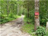 2
2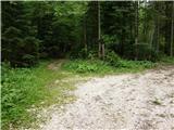 3
3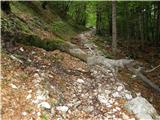 4
4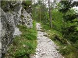 5
5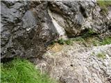 6
6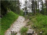 7
7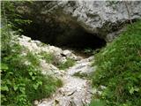 8
8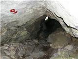 9
9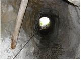 10
10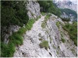 11
11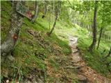 12
12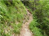 13
13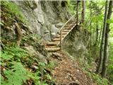 14
14 15
15 16
16 17
17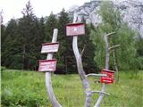 18
18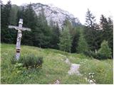 19
19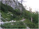 20
20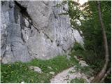 21
21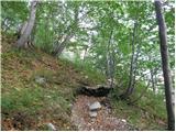 22
22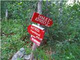 23
23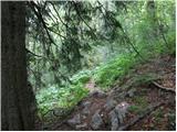 24
24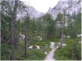 25
25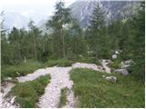 26
26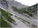 27
27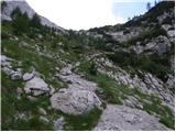 28
28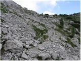 29
29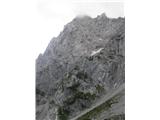 30
30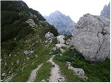 31
31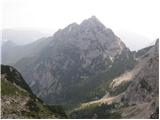 32
32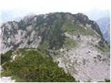 33
33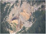 34
34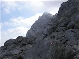 35
35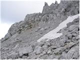 36
36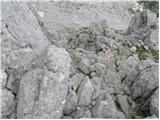 37
37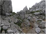 38
38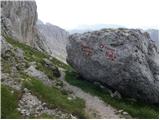 39
39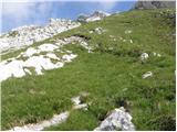 40
40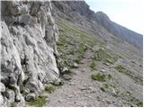 41
41 42
42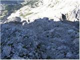 43
43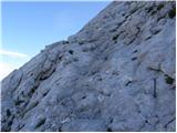 44
44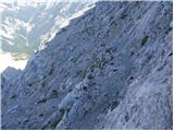 45
45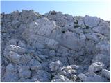 46
46 47
47
Discussion about the trip Na Razpotju - Ojstrica (via Škarje)
|
| jboc12. 07. 2010 |
On 25.6., on holiday, I went to Klemenčeva jama. I met three female hikers who continued to Ojstrica, Planjava and returned to Logarska dolina via Kamniško sedlo. I talked with one of them about our back problems. If she reads this by chance, please contact me.
|
|
|
|
| Matjaz_6517. 07. 2011 |
a few more of my photos ... starting point at the mountaineers' hut ... ascent via Kopinškova ... descent through Škarje 
|
|
|
|
| ZOJA1. 07. 2012 |
today husband and I on Ojstrica via mentioned path...says 4h15...we took 5.5h up...don't know if wrong with us or writer exaggerates...what say other hikers?
|
|
|
|
| otiv1. 07. 2012 |
@zoja definitely warm weather to blame, it suits me up to 10°C and then good walking without effort.
|
|
|
|
| ZOJA2. 07. 2012 |
of course you're right, otiv....but trails in the mountains should be written for the average hiker....or not...
|
|
|
|
| otiv2. 07. 2012 |
@zoja the important thing is that you had a good time and let the times not spoil your mood. I usually took three hours to the top of Ojstrica, of course in weather that suits me, rather cold than warm.
|
|
|
|
| dprapr2. 07. 2012 |
As otiv says, it's senseless to worry about time. When we're in the mountains, we actually want it to last as long as possible and we delay the descent to the valley.
Anyway, in this heat it's not appropriate to rush and expose oneself.
In my opinion, that time (4:15h) is quite appropriate - less is fast, more is more enjoyable.
Best regards
|
|
|
|
| Kriška2. 07. 2012 |
Zoja, I think you walked exactly "to standard" (which trail describers in recent years rarely adhere to - just like trail categorizations). If you look at the elevation gain (1580 m) and know that according to the rules (which at least formerly applied) it's normal to cover 300 vertical meters per hour (often you have to add the distance), then you see that you could hardly have walked more "by the rules" than you did!
|
|
|
|
| ZOJA2. 07. 2012 |
Thanks for the comments....we wanted to avoid the great heat, as we started already at half past four...then we baked for almost three hours in the sun on the way back... best regards
|
|
|
|
| katja8723. 03. 2014 |
Yesterday, 22.3.2014, in the framework of the winter course on safe walking, we ascended to Škarje below Ojstrica.
The initial goal was actually the summit of Ojstrica, but due to bad weather and visibility and strong gusts of wind, we only went up to Škarje. The path was quite strenuous and demanding, mainly due to poor conditions. At the same time, the snow was quite wet, so it sank deeply in places.
In the end, we of course forgot all the effort and were very satisfied with the tour 
You can see photos from the tour on the website of the Matica Murska Sobota Mountaineering Association: http://www.mojalbum.com/pdmaticams/20140322-skarje-pod-ojstrico-zimski-tecaj/izhodisce-pri-penzijonu-na-razpotju/21573735
|
|
|
|
| Marx22. 06. 2015 |
Hm, the most difficult part of the trail is poorly described. That's the part from Škarje to the point where we join the trail from Kocbekov dom. That's the toughest section of this trail where you cross very steep slopes, secured only with pegs. The most tricky is crossing one scree where snowfield can last long into the year. There's the only cable and it's in poor condition. Caution is needed on this section.
We can avoid this section. At the junction in picture 41 we go down. After a while
we reach the trail that goes from Kocbekov dom. We join the described trail before the final ascent to the top over the scree. This extends the trail by about 20 minutes.
And yes, the junction where we branch off from the trail from Ojstrica summit to Kocbekov dom for Škarje (but also for Planjava via Velika Zelenica) is poorly marked. No signpost, just iron poles.
|
|
|
|
| Majmr8. 07. 2021 11:56:30 |
Is there still a lot of snow on the path to the junction at Škarje?
|
|
|
|
| garmont8. 07. 2021 19:50:09 |
The path from Klemenča jama towards Škarje, from the junction for Kopinškovo onwards, is still quite substantially snowy.
|
|
|
|
| Mojcak24. 07. 2021 13:27:10 |
Hello, I'm interested whether the trail is suitable for a dog that is otherwise experienced in the mountains?
|
|
|
|
| ppegan24. 07. 2021 13:54:59 |
If the dog is really used to the mountain world, then yes. I would go with mine without problems.
|
|
|
|
| Mojcak25. 07. 2021 18:24:47 |
I'm reporting that it's impossible for a dog, since from the Škarje pass after a short descent, where it says it becomes more demanding, it's so steep that you can only carry the dog over the rock, which is impossible for ours due to size.
|
|
|
To post a comment you must log in:
If you do not yet have a username, you must first
register.