Na Razpotju - Rjavčki vrh (Planinšca)
Starting point: Na Razpotju (770 m)
| Latitude/Longitude: | 46,39200°N 14,62730°E |
| |
Walking time: 3 h
Difficulty: partly demanding marked way, easy pathless terrain
Elevation gain: 1128 m
Elevation difference along the route: 1128 m
Map: Kamniške in Savinjske Alpe 1:50.000
Recommended equipment (summer): helmet
Recommended equipment (winter): helmet, ice axe, crampons
Views: 11.133
 | 1 person like this post |
Access to starting point:
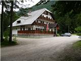
We drive to Luče (to here from Mozirje or via Kranjski Rak) and further towards Logarska dolina. Soon after the village Solčava we come to the junction, where the road to Logarska dolina branches off to the left. We turn left towards Logarska dolina (toll payment) and drive along the road to the signs for the mountain hut at Klemenča jama. We park on the parking lot near the pension Na Razpotju. In front of the pension only guests are allowed to park.
Route description:
From the parking lot, we head onto the forest road in the direction of Klemenča jama. After a few minutes of walking, a wide path branches off to the left towards Klemenča jama. We take this path, which starts to ascend. A fairly steep path soon brings us to steep slopes, where with the help of a steel cable we cross a slightly exposed gully. The path, which continues ascending, soon brings us to the spot where a wall blocks the path. In front of us we spot a cave and above it a marker that directs us into the cave. When we step into the cave we see that it is not a cave, but a nicely made tunnel through which we continue. In the tunnel a steel cable assists us, which we need more on the descent than on the ascent. On the other side, along a wide path in a gentle ascent, we cross an exposed ledge. The path ahead goes into the forest and continues ascending on steep slopes that are dangerous for slipping when wet. Further, over a small bridge, we cross another gully, then the path brings us to a less steep section, where the path from the Dom Planincev joins us. We continue slightly uphill on a wide path that soon takes us out of the forest. Only a short ascent on a grassy slope to the mountain hut at Klemenča jama follows.
From the hut we continue straight in the direction of Ojstrica on the path that enters the forest after a few dozen meters. The path, which ascends moderately to steeply through the forest, brings us higher below rocky cliffs that are not overly crumbly. The path then veers right away from the cliffs and brings us to a junction, where we continue straight towards Škarje, while to the left branches the very demanding Kopinškova pot to Ojstrica. The path continues crossing the slopes towards the west, then emerges from the forest and turns slightly to the left. Here it begins to ascend somewhat more steeply beside scree, then turns right and climbs towards the saddle below Rjavčki vrh (1898 m).
On the saddle (or even a little before) we leave the marked path and continue the ascent to the right on easier pathless terrain. After approximately 10 minutes of ascent on a partly grassy slope, we reach the dwarf pine-covered Rjavčki vrh, from which a nice view opens up on the mountains above Logarska dolina.

The trip can be extended to the following destinations: Matkov kot
Photos:
 1
1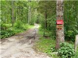 2
2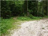 3
3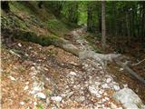 4
4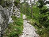 5
5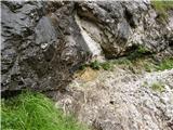 6
6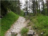 7
7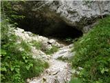 8
8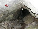 9
9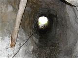 10
10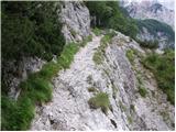 11
11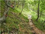 12
12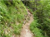 13
13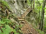 14
14 15
15 16
16 17
17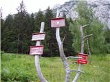 18
18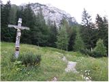 19
19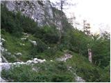 20
20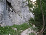 21
21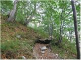 22
22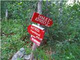 23
23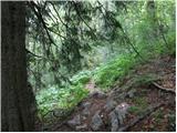 24
24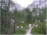 25
25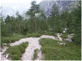 26
26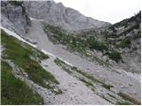 27
27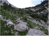 28
28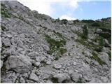 29
29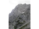 30
30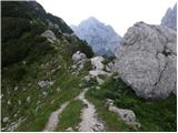 31
31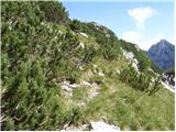 32
32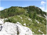 33
33 34
34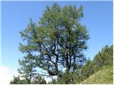 35
35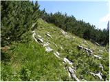 36
36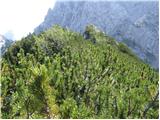 37
37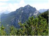 38
38
Discussion about the trip Na Razpotju - Rjavčki vrh (Planinšca)
|
| micamaca17. 08. 2010 |
Has anyone been over Grlo to Rjavški vrh recently?
|
|
|
|
| aljazek18. 08. 2010 |
I went through Grlo. If you search well for the path, there really are no problems, I lost it several times (more than once I complicated it on purpose - I like climbing  ), so I had to climb the rocky jumps. I think the biggest problems are because the trail is even harder to see from below up. Matta is right, viewed from below up -> at the beginning you stick more to the right (Planjava wall), then after the first rocky jump (under that wall where a lot of stones fall down) you cross to the left and stick to the slope of Rjavčki vrh. But I went directly through the middle, over those slabs ), so I had to climb the rocky jumps. I think the biggest problems are because the trail is even harder to see from below up. Matta is right, viewed from below up -> at the beginning you stick more to the right (Planjava wall), then after the first rocky jump (under that wall where a lot of stones fall down) you cross to the left and stick to the slope of Rjavčki vrh. But I went directly through the middle, over those slabs 
|
|
|
|
| micamaca18. 08. 2010 |
Hey, thanks for the tips everyone! I'm already looking forward to it, because this path "torments" me extremely and I won't have peace until I go on it but I need to rest my knee a bit first
|
|
|
|
| donidoni21. 08. 2010 |
Today to Rjavčki vrh via Grlo. To the jump you go along the torrent bed but look for better variants, after the jump keep right the path can be followed a bit before the walls cross left over rocky plateaus and spot the path which is nicely followed to the cirque below the saddle. In the cirque keep left below the walls and along the edge of the scree to the saddle, the path is nicely followed.
Nice ascent to R. vrh.
LP
|
|
|
|
| Alni24. 07. 2012 |
On Saturday I would like to go on this trail. Is the trail suitable for beginners?
Thank you!
|
|
|
|
| plaNinaPirsMajcen21. 10. 2025 17:42:56 |
Hi, a few days ago I hiked this trail and I must say that the solitary, lesser-known Rjavčki vrh enchanted me. Actually the whole trail, I also captured the glowing larches.
I recorded a video of the experience, enjoy watching.
https://youtu.be/pe6Jg-Nzx0Q?si=5CbTXa95UwjrTFkK
In the video I also marked the unmarked junction. From the saddle onwards to the summit there is a poorly visible path, but orientation is no problem as we can see the summit from the saddle.
Best, Nina
|
|
|
To post a comment you must log in:
If you do not yet have a username, you must first
register.