Starting point: Ocinje (292 m)
| Latitude/Longitude: | 46,82254°N 16,00183°E |
| |
Walking time: 20 min
Difficulty: easy unmarked way
Elevation gain: 8 m
Elevation difference along the route: 45 m
Map: Pomurje 1:40.000
Recommended equipment (summer):
Recommended equipment (winter):
Views: 97
 | 1 person like this post |
Access to starting point:
We drive to Gederovce (from Murska Sobota or Radenci to here), then continue driving towards Kuzmi. After Rogašovci we arrive in Nuskovo, a little further on in Serdica, where signs for Ocinje direct us to the left. In the continuation we ascend to a smaller pass, from which we descend into Ocinje. This is followed by a more pronounced left turn, then we go right, where we park at the parking lot below the cemetery.
Route description:
From the parking lot we continue along the macadam road, which continues towards the northwest. Initially we ascend along the pine forest, then after the apiary we arrive among the fields, from where a beautiful view of Goričko opens up to us. Higher up the road levels out, at the fork we choose the road that leads straight (right Apenini breg).
The path ahead gradually begins to descend and leads us into the forest, where we continue descending along a somewhat worse forest road. In a few minutes of descent we arrive at the memorial at Črni kamen, which we notice on the right side of the path.
The description refers to the state in February 2026; the pictures are from various periods.
Photos:
 1
1 2
2 3
3 4
4 5
5 6
6 7
7 8
8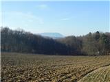 9
9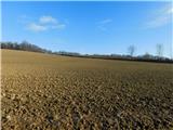 10
10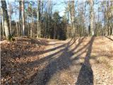 11
11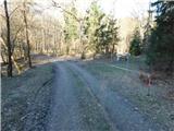 12
12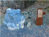 13
13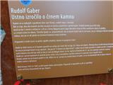 14
14
Discussion about the trip Ocinje - Črni kamen
To post a comment you must log in:
If you do not yet have a username, you must first
register.