Starting point: Osp (57 m)
| Latitude/Longitude: | 45,57130°N 13,85700°E |
| |
Walking time: 1 h
Difficulty: easy marked way
Elevation gain: 317 m
Elevation difference along the route: 317 m
Map: Primorje in Kras 1:50.000
Recommended equipment (summer):
Recommended equipment (winter):
Views: 34.908
 | 3 people like this post |
Access to starting point:
From the highway Ljubljana - Koper, we take the exit Črni Kal and follow the road ahead towards Črni Kal and Osp. At the beginning of the ascent towards Črni Kal, the road towards the village Osp branches off to the left. The road then runs past the pillars of the viaduct and after a short descent brings us to the village Osp, where the described path begins in the middle of the settlement.
Route description:
From the center of the settlement, we go in the direction of the camp and Tinjan, and the road after the camp brings us to a little bridge and behind it quickly to a junction, where we continue right and then immediately left. Further on, we ascend gently on a worse but well-marked road. After a few minutes of the ascent, the markers direct us to the right onto a footpath which ascends through a belt of quite overgrown forest. When we come out of the forest, we step onto expansive grassy slopes from which we clearly see the antenna tower on Tinjan. The path then goes again into the forest, where it moderately ascends across numerous but well-marked junctions. A little below the summit of Tinjan we again step onto the road, which we follow past a water supply structure to a scenic bend. At the beginning of the bend, the markers direct us to the left upwards and the path in a moderate ascent quickly brings us to the top.
Photos:
 1
1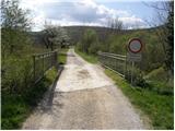 2
2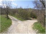 3
3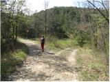 4
4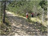 5
5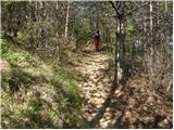 6
6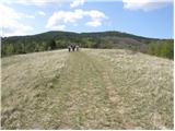 7
7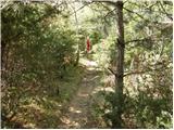 8
8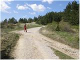 9
9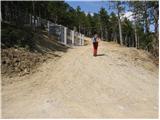 10
10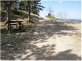 11
11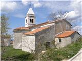 12
12
Discussion about the trip Osp - Tinjan
|
| grahlck8. 03. 2009 |
Can someone tell me from where you can reach Tinjan by car?
|
|
|
|
| andymann8. 03. 2009 |
You go along the motorway from Črni Kal onwards, drive towards the border Škofije, but exit the motorway down to Škofije, where there is a right turn-off to Tinjan. Something like that. Otherwise, it's easier if you look at the map: http://www.geopedia.si/#T105_vT_b4_x407510_y47017_s14
|
|
|
|
| Lucy23. 01. 2011 |
The path has often taken me to the coast, but this time, for a change, I visited the Osp Valley. I stopped in the village of Osp. From there I headed to the nearby hill Tinjan. The path passes by the campsite and gradually climbs to the church at the top of Tinjan. It's a walking path that in this season offers pleasant exercise and a nice view of Trieste and surroundings. The path is well marked and maintained. These areas are somewhat neglected unjustly and it would be nice if more people decided to visit.
|
|
|
|
| Janiel7428. 04. 2012 |
Stamp is at hut Tinjan 28 
|
|
|
|
| kenig28. 06. 2013 |
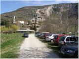
No ink pad at the stamp and if you park at the camp as shown in picture 1, you get raised wipers and a note: No Park. Private!
|
|
|
|
| malena14. 08. 2013 |
You park at the parking lot, pay the parking fee and that's it.
Otherwise a beautiful path. The gentleman who lives at the house where the stamp is got talking and wouldn't let me and mine go.
|
|
|
|
| SunnyDay31. 10. 2013 |
Super ascent for winter .
|
|
|
|
| claire19. 07. 2014 |
The stamp is located in Ankaran, in the Korta bar.
|
|
|
|
| Kigeot18. 10. 2014 |
I parked at the only parking spot in front of the campsite (maybe 2 cars could fit), the rest was all blocked or private yards. I couldn't find the "official" parking in Osp.... shame
Personally, this trail is nothing special to me, the view is only on the meadow and right before the summit. Shame, because it's one of the few hills on the Coast, otherwise the path under the Črni Kal wall and along the top of the wall is much nicer and more varied, but it's true, it's short, and with minimal ascent.
|
|
|
|
| slavkoo12. 04. 2015 |
Now you can't park next to the camp anymore. But there's a gravel parking lot about 500 meters before Osp on the left side by the road.
|
|
|
|
| grega8822. 07. 2016 |
Both stamps and the logbook are now, with the permission of the landowner, built into the church wall at the top of Tinjan. At this spot, there is also an arranged viewpoint with extensive views, and in the pleasant shade, a bench and running water await you. [source: PZS]
|
|
|
To post a comment you must log in:
If you do not yet have a username, you must first
register.