Parkirišče pod planino Jamnig - Feldseekopf (via Feldseecharte)
Starting point: Parkirišče pod planino Jamnig (1685 m)
| Latitude/Longitude: | 47,00212°N 13,11081°E |
| |
Route name: via Feldseecharte
Walking time: 3 h 50 min
Difficulty: easy marked way
Elevation gain: 1179 m
Elevation difference along the route: 1190 m
Map:
Recommended equipment (summer):
Recommended equipment (winter):
Views: 1.010
 | 4 people like this post |
Access to starting point:
Drive to Spittal and take the exit for Lienz. Then follow the regional road past Lendorf, after which, after a few kilometers, turn right in the direction of Möllbrücke, Mühldorf and Obervellach. Soon after Obervellach, turn right towards Mallnitz. In Mallnitz, drive past the railway station (also motorail to Böckstein through the 8370 m long Tauern tunnel) and then follow the signs for Jamnigalm and Hagenerhütte (at this junction there are about 15 green signs), since the road in the town still turns left. The road soon leads out of the town and reaches a barrier, where it is necessary to pay a toll of 4 euros in the machine (status for 2018, note: the machine accepts only coins). The road leads to the parking lot under the Jamnig pasture.
Route description:
From the parking lot, walk a few tens of meters back along the road, turn right over the bridge and follow the serpentine road to the Jamnig pasture, to which it is 5 to 10 minutes walk. The forest ends with the pasture.
At the Jamnig pasture continue left. At the beginning the path crosses grassy slopes and ascends very gently in the direction towards the west.
The path then passes into a steeper section, where entire slopes are overgrown with blueberries (therefore this area is popular with gatherers). Occasionally some torrent stream is crossed, where it is good to have a long step (some child can have problems here).
The path becomes the steepest in the last third, where it ascends along the slopes towards the bivouac. The path then joins the Hagenerweg path, which leads to the Hagener hut. Here continue left and after five minutes arrive at the bivouac (Dr. Rudolf Weißgerber Biwak).
At the bivouac there is a nice view on the west side towards the lakes and to the east towards the valley and Mallnitz.
From the bivouac the path ascends towards the summit of Feldseekopf. The path is steep, but easy all the time. After half an hour of walking the path levels out under the summit and finally climbs to the summit in two steeper meters. On the summit there is a rocky cairn.
The views are excellent on all sides. To the west lower-lying lakes glitter (the lowest of them is Feldsee). To the east lies the valley and mountain town Mallnitz and on the horizon three-thousanders Hochalmspitze, 3360 m and Ankogel, 2252 m. To the south the world is even more open, because here in the distance the Julian Alps are also visible, west of them the Carnic Alps. Closer rises Polinik, 2784 m. To the north the view is blocked by nearby Hinterer and Vorderer Geißlkopf (2888 m and 2974 m). The approach to them from this side looks considerably more difficult than it is in reality.

Along the route: Jamnigalm (1750m), Dr. Rudolf Weißgerber Biwak (bivouac) (2712m)
Photos:
 1
1 2
2 3
3 4
4 5
5 6
6 7
7 8
8 9
9 10
10 11
11 12
12 13
13 14
14 15
15 16
16 17
17 18
18 19
19 20
20 21
21 22
22 23
23 24
24 25
25 26
26 27
27 28
28 29
29 30
30 31
31 32
32 33
33 34
34 35
35 36
36 37
37 38
38 39
39 40
40 41
41 42
42 43
43 44
44 45
45 46
46 47
47 48
48 49
49 50
50 51
51 52
52 53
53 54
54 55
55 56
56 57
57 58
58 59
59 60
60 61
61 62
62 63
63 64
64 65
65 66
66 67
67 68
68 69
69 70
70 71
71 72
72 73
73 74
74 75
75 76
76 77
77 78
78 79
79 80
80 81
81 82
82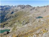 83
83
Discussion about the trip Parkirišče pod planino Jamnig - Feldseekopf (via Feldseecharte)
To post a comment you must log in:
If you do not yet have a username, you must first
register.