Parkirišče pod planino Jamnig - Hinterer Geißlkopf
Starting point: Parkirišče pod planino Jamnig (1685 m)
| Latitude/Longitude: | 47,00229°N 13,11076°E |
| |
Walking time: 4 h 40 min
Difficulty: partly demanding marked way
Elevation gain: 1203 m
Elevation difference along the route: 1260 m
Map:
Recommended equipment (summer):
Recommended equipment (winter): helmet, ice axe, crampons, lamp
Views: 398
 | 3 people like this post |
Access to starting point:
Drive along the motorway to Spittal and the exit for Lienz. Then follow the regional road past Lendorf, after which, after a few kilometres, turn right towards Möllbrücke, Mühldorf and Obervellach. Soon after Obervellach, turn right towards Mallnitz. In Mallnitz, drive past the railway station (also motorail to Böckstein through the 8370 m long Tauern tunnel), then follow the signs for Jamnigalm and Hagenerhütte (at this intersection there are about 15 green signs), as the road also turns left in the village. The road soon leads out of the village and reaches a barrier, where you need to pay 4 euros in the machine (status for 2018, note: the machine takes only coins). The road leads to the parking lot below Jamnig pasture.
Route description:
From the parking lot, walk a few tens of metres back along the road, turn right over the bridge and follow the serpentine road to Jamnig pasture, which is a 5 to 10 minute walk.
The forest ends at the pasture. To the hut, you then always walk on a wide path that ascends gently in serpentines. On the left are clearly visible the mountains Feldseekopf and Vorderer Geißlkopf, on the right rises the slope of Greilkopf. The path splits only five minutes before the hut, where you turn left towards the hut.
From the hut, the path descends to the signposts, next to which stands a bell, and continues towards the west. The path gently leads to the ground spring and then begins to ascend. About 150 height metres later, the path reaches the saddle, from which the 2727 m high Westerfrölkekogel rises towards the north. The path is a little crumbly just below the saddle and requires careful steps. Since the ridge rises very steeply to the left of the saddle, the path crosses it in the right lower part, first descending into a small basin, over which you need to cross some rock slabs and then ascend towards the ridge.
The ridge is then a nice flat terrain that first ascends gently, then the terrain becomes steeper again. The path then leads over some kind of fore-summit, from which a nice view opens onto the summit of Vorderer Geißlkopf. In early summer - up to the beginning of August and in early autumn (e.g. first snow) – snow persists on the northern slopes.
The path runs along the northern slope below the summit of Vorderer Geißlkopf to the ridge between the mountains Vorderer and Hinterer Geißlkopf. From here, simply follow the ridge westwards to the summit, from which there is a nice view of the adjacent summit Vorderer Geißlkopf and the lake and Feldseekopf to the south. In the distance to the west, Veliki Klek is also visible. Northwards some 1500 metres lower lies the valley that runs to Sportgastein.
Starting point – Hagener Hütte (2 h 30 min); Hagener Hütte – Hinterer Geißlkopf (2 h 10 min).

Photos:
 1
1 2
2 3
3 4
4 5
5 6
6 7
7 8
8 9
9 10
10 11
11 12
12 13
13 14
14 15
15 16
16 17
17 18
18 19
19 20
20 21
21 22
22 23
23 24
24 25
25 26
26 27
27 28
28 29
29 30
30 31
31 32
32 33
33 34
34 35
35 36
36 37
37 38
38 39
39 40
40 41
41 42
42 43
43 44
44 45
45 46
46 47
47 48
48 49
49 50
50 51
51 52
52 53
53 54
54 55
55 56
56 57
57 58
58 59
59 60
60 61
61 62
62 63
63 64
64 65
65 66
66 67
67 68
68 69
69 70
70 71
71 72
72 73
73 74
74 75
75 76
76 77
77 78
78 79
79 80
80 81
81 82
82 83
83 84
84 85
85 86
86 87
87 88
88 89
89 90
90 91
91 92
92 93
93 94
94 95
95 96
96 97
97 98
98 99
99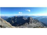 100
100
Discussion about the trip Parkirišče pod planino Jamnig - Hinterer Geißlkopf
To post a comment you must log in:
If you do not yet have a username, you must first
register.