Parkirišče pod planino Jamnig - Vordere Geislspitze / Vorderer Gesselkopf
Starting point: Parkirišče pod planino Jamnig (1685 m)
| Latitude/Longitude: | 47,00229°N 13,11076°E |
| |
Walking time: 4 h 30 min
Difficulty: partly demanding marked way
Elevation gain: 1289 m
Elevation difference along the route: 1350 m
Map:
Recommended equipment (summer):
Recommended equipment (winter): helmet, ice axe, crampons, lamp
Views: 1.050
 | 2 people like this post |
Access to starting point:
Drive on the motorway to Spittal and take the exit for Lienz. Then along the regional road past Lendorf, after which, after a few kilometers, turn right in the direction of Möllbrücke, Mühldorf and Obervellach. Soon after Obervellach turn right towards Mallnitz. In Mallnitz pass the railway station (also motorail to Böckstein through the 8370 m long Tauern tunnel) then follow the signs for Jamnigalm and Hagenerhütte (at this crossroads there are about 15 green signs), as the road in the town still turns left. The road soon leads out of the town and reaches a barrier, where 4 euros must be paid in the machine (status for 2018, note: the machine takes only coins). The road leads to the parking lot below the Jamnig pasture.
Route description:
From the parking lot walk a few tens of meters back along the road, turn right over the bridge and follow the serpentine road to the Jamnig pasture, which is a 5 to 10 minute walk.
The forest ends at the pasture. To the goal one then always walks along a wide path, which ascends gently in serpentine fashion. On the left are clearly visible the mountains Feldseekopf and Vorderer Geißlkopf, on the right rises the slope of the mountain Greilkopf. The path forks only five minutes before the goal, where one must turn left towards the hut.
From the hut the path descends to the signposts, next to which stands a bell, and continues towards the west. The path gently leads to the ground-level spring source and then begins to ascend. About 150 elevation meters later the path leads to the saddle, from which towards the north rises the 2727 m high Westerfrölkekogel. The path a little below the saddle is somewhat crumbly and requires careful steps. Because the ridge to the left of the saddle rises very steeply, the path crosses it in the right lower part, first descending into a small basin, over which some rock slabs must be crossed and then ascending towards the ridge.
The ridge is then a nice flat landscape, which first ascends gently, then the terrain becomes steeper again. The path then leads over some kind of pre-summit, from which a nice view opens onto the summit of Vorderer Geiselkopf. In early summer - possibly until the beginning of August and in early autumn (e.g. first snow) – snow persists stubbornly on the northern slopes.
The final ascent to the mountain is possible from the eastern direction (somewhat shorter, but slightly steeper) and from the western direction (about 5 to 10 minutes longer path). The technically most demanding part is a few meters below the summit, where a few meters of steel cable provide assistance (it is possible to find an easier passage 10 meters to the side).
On the summit a cross and register book await the hiker. From the summit numerous three-thousanders are nicely visible. Towards the west the nearest is Schareck, farther away Sonnblick, towards the east Ankogel and Hochalmspitze.
Starting point – Hagener Hütte (2 h 30 min); Hagener Hütte – Vorderer Geiselkopf (2h).

Photos:
 1
1 2
2 3
3 4
4 5
5 6
6 7
7 8
8 9
9 10
10 11
11 12
12 13
13 14
14 15
15 16
16 17
17 18
18 19
19 20
20 21
21 22
22 23
23 24
24 25
25 26
26 27
27 28
28 29
29 30
30 31
31 32
32 33
33 34
34 35
35 36
36 37
37 38
38 39
39 40
40 41
41 42
42 43
43 44
44 45
45 46
46 47
47 48
48 49
49 50
50 51
51 52
52 53
53 54
54 55
55 56
56 57
57 58
58 59
59 60
60 61
61 62
62 63
63 64
64 65
65 66
66 67
67 68
68 69
69 70
70 71
71 72
72 73
73 74
74 75
75 76
76 77
77 78
78 79
79 80
80 81
81 82
82 83
83 84
84 85
85 86
86 87
87 88
88 89
89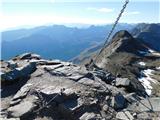 90
90
Discussion about the trip Parkirišče pod planino Jamnig - Vordere Geislspitze / Vorderer Gesselkopf
To post a comment you must log in:
If you do not yet have a username, you must first
register.