Parking Stubaier Gletscher (Mutterbergalm) - Zuckerhütl (normal approach from the west)
Starting point: Parking Stubaier Gletscher (Mutterbergalm) (1692 m)
Starting point Lat/Lon: 47.01324°N 11.15504°E 
Path name: normal approach from the west
Time of walking: 5 h
Difficulty: very difficult unmarked way
Difficulty of skiing: very demanding
Altitude difference: 1815 m
Altitude difference (by path): 1815 m
Map: Stubaier Alpen Hochstubai, 31/1 1:25.000; Outdooractive Stubai Wanderkarte
Access to starting point:
From Ljubljana, we drive on the highway past Salzburg in the direction towards München. At the multilevel junction Dreieck Inntal we go on the road A93 in the direction of Innsbruck/Kufstein/Brenner. When we return to Austria we continue to the junction with the exit Innsbruck-Mitte. Here we don't turn towards Innsbruck, but we continue on the highway A13 in the direction towards the mountain pass Brenner. We leave the highway at the exit 10-Schönberg and we follow a comfortable road through the valley Stubaital to settlements Neustift im Stubaital, the center of valley Stubaital, and Volderau, where still a wide asphalt road starts ascending a little more in the direction of Mutterbergalm and ski slope "Stubaier Gletscher". We soon on the left notice large waterfall Grawa and a parking lot at the eponymous mountain pasture, and a little higher also a parking lot intended for the ascent towards Sulzenauhütte. After few minutes of additional driving, we park on one of the numerous parking lots below the ski slope "Stubaier Gletscher".
Alternatively we can drive through northern Italy: in this case from the main Slovenia on the highway A2 we drive to one of the border crossings with Austria and we continue towards Lienz. Here we continue on the road 100 and past the passage Prato alla Drava we drive into Italy. In Italy we follow the road SS49 all the way to the juncture with highway A22 in the direction towards the mountain pass Brenner. After the mountain pass, we continue in the direction towards Innsbruck to the exit Schönberg. From there we continue as described above.
Path description:
Majority of hikers on Zuckerhütl ascends by using cableways (Eisgrat I and II and Schaufeljoch) to the upper station of the cableway Schaufeljoch (3158 meters) and from there descends towards the station Fernaujoch (chairlift Fernau in the summer doesn't operate). This description refers to more orthodox ascent variant, where from the parking lot towards the saddle Fernaujoch we go on foot; this version is especially appropriate for a descent and in case if we want to avoid high ticket price.
A little above the bottom station of the cableway Eigrat I we cross a small bridge and following the signpost we go left on the path which leads towards Dresdner Hütte. A well-marked path at first comfortably leads on a footpath among rare vegetation, and after approximately half an hour of walking it ascends a little steeper on a grassy slope. The footpath which in zig-zags overcoming the steepness, after less than an hour and a half brings us to the hut Dresdner Hütte.
At the mountain hut by the edge of the ski slope we get on the road which by some shortcuts leads towards the bottom station of the chairlift Fernau. Here we go firmly towards the south and through the glacier Fernauferner we ascend to the from the far visible saddle Fernaujoch. When crossing the glacier it is the easiest to orientate if we roughly follow the route of the chairlift, but in the summer we can usually follow the traces of predecessors. The orientation in clear weather isn't demanding.
On Fernaujoch joins the path which from west comes from the upper station of the cableway Schaufeljoch; this path is approximately hour and a half shorter as the described one. We continue the ascent eastern on a long ridge, which from Fernaujoch spans towards the western walls of Aperer Pfaff; the ridge is crumbly, but it isn't very precipitous, and at orientation we get help from cairns.
At an altitude approx. 3220 meters the footpath turns towards the south and bypasses the final part of southwestern ridge of Aperer Pfaff. Unmarked footpath then leads on the scree leads to obvious mountain pass Pfaffenjoch (3208 meters) by the edge of the glacier Sulzenauferner. In the reverse direction in the view of a little opaque terrain, sometimes it is hard to find the right path between Pfaffenjoch and the ridge, which leads towards Fernaujoch.
On the mountain pass, we cross rocks and we descend towards the glacier Sulzenauferner. Follows a little less than an hour of walking on a wide glacier, where in the direction towards the southeast we cross below the entire northern wall of Zuckerhütl. Because of the popularity of the path, we can throughout the year reasonably expected visible path, which will help us at the orientation.
Eastern from Zuckerhütl we ascend a little steeper to the spot, where joins the path which comes from the peak Wilder Pfaff (from here is an easy and relatively fast access to the top). From here to the right from the precipitous edge we in few minutes ascend to the foot of the rocky upper massif of Zuckerhütl. Before the demanding final ascent, at the foot it makes sense to put down your backpack.
The ascent on the eastern side of Zuckerhütl is short, but in the view of precipitous crumbly terrain it is objectively quite dangerous, which is especially true in the case if above us are ascending other mountaineers. The optimal course of the path otherwise somewhat dependent on current condition, even if for orientation we can use individual blazes and bolts, which provide belaying on tricky spots.
From the foot the rocky slope we at first ascend on unstable rugged crumbly slope, and then we cross a little towards the south. After a shorter exposed crossing on an appropriate passage we climb to a little less steep terrain below the summit. Following the signs and anchors we ascend on a steep band and through easier passable upper terrain we ascend on a less spacious, but very panoramic peak with a large cross.
The final ascent on Zuckerhütl is short, but potentially a rather tricky act, which is especially true on crowded days. Climbing doesn't exceed II. grade, but the path is in parts precipitous, and the rock is very crumbly. Zuckerhütl is otherwise also the highest point of popular trail "7 summits of Stubai".
For less experienced I recommend belaying with a rope or ascent with a mountain guide.
On the way: Dresdner Hütte (2308m), Fernaujoch (3055m)
Pictures:
 1
1 2
2 3
3 4
4 5
5 6
6 7
7 8
8 9
9 10
10 11
11 12
12 13
13 14
14 15
15 16
16 17
17 18
18 19
19 20
20 21
21 22
22 23
23 24
24 25
25 26
26 27
27 28
28 29
29 30
30 31
31 32
32 33
33 34
34 35
35 36
36 37
37 38
38 39
39 40
40 41
41 42
42 43
43 44
44 45
45 46
46 47
47 48
48 49
49 50
50 51
51 52
52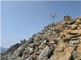 53
53 54
54