Starting point: Passo di Giau (2233 m)
| Latitude/Longitude: | 46,48250°N 12,05380°E |
| |
Walking time: 1 h 55 min
Difficulty: very difficult marked way
Elevation gain: 416 m
Elevation difference along the route: 600 m
Map: Tabacco 03 1:25.000
Recommended equipment (summer): helmet, self belay set
Recommended equipment (winter): helmet, self belay set, ice axe, crampons
Views: 11.461
 | 1 person like this post |
Access to starting point:
First, we drive to Cortina d'Ampezzo (you can get here via the border crossing at Rateče or Predel to Trbiž / Tarvisio and then on the highway in the direction of Udine to the Tolmezzo exit. From Tolmezzo, we follow the road in the direction of the settlement Ampezzo and mountain pass Passo della Mauria. The road then descends and brings us to an intersection, where we continue left (also right is possible) in the direction of Cortina d'Ampezzo. At all subsequent intersections, we follow the signs for Cortina d'Ampezzo. Or from the Primorska side, where we drive on the highway in the direction of Trst / Trieste. Further, we drive on the Italian highway in the direction of Padova, but only to the highway junction, where we continue in the direction of the region Veneto and Belluno. Near Belluno, the highway ends, and we continue at the next intersections in the direction of Cortina d'Ampezzo and then follow the signs for the alpine pass Passo di Falzarego. We then follow this ascending road to an intersection at an altitude of approximately 1400 m. At the intersection, we continue left in the direction of the alpine pass Passo di Giau and Marmolada. We park on the large parking lot at the mentioned alpine pass.
Route description:
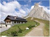
From the pass, we continue on a wide path past the hut Rifugio Passo Giau. After a short ascent on the wide path, we come to a junction, where path 443 branches off to the right. We continue upwards on the wide path, then the path becomes narrower and turns slightly left onto the west side of the mountain Ragusela. Here the path starts to descend and crosses scree towards the north. Later, the path starts to ascend a quite steep and also slightly crumbly slope, which brings us to grassy slopes. From the grassy slopes, we soon join the wide path from the hut Rifugio Fedare (2000 m) and a short ascent to the hut Averau follows.
From the hut, we continue straight past the hut on the mountain road. Already after a few meters, the sign »Ferrata Averau« directs us left upwards. The path then first crosses scree on the eastern side of the mountain and soon turns left, where we enter the climbing part of the path. At the beginning of the climbing path, we ascend steeply along the steel cable over a steep wall, then we come to a path junction. The left slightly easier path ascends vertically on brackets through a chimney. The right path also ascends almost vertically, only without brackets on the path. It should be noted that the left path is often damp and snow lingers somewhat longer. After a short steep section of the path, both paths reunite and a traverse to the right with the help of the steel cable follows. The climbing part of the path ends quickly and we soon come to less steep summit slopes of the mountain. In the last part, the path is no longer demanding and we soon reach a very scenic summit.

Photos:
 1
1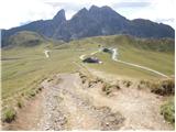 2
2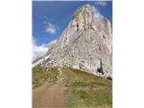 3
3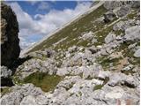 4
4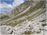 5
5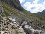 6
6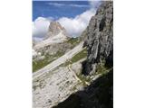 7
7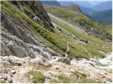 8
8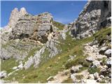 9
9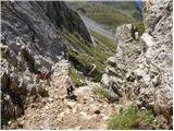 10
10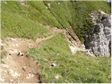 11
11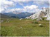 12
12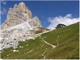 13
13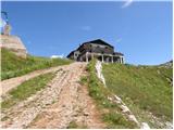 14
14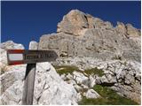 15
15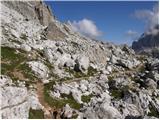 16
16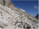 17
17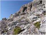 18
18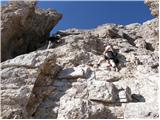 19
19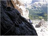 20
20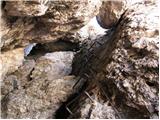 21
21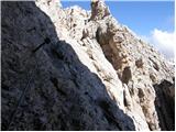 22
22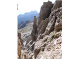 23
23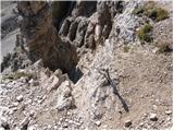 24
24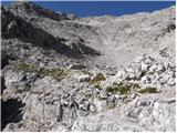 25
25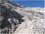 26
26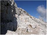 27
27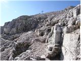 28
28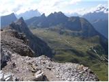 29
29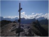 30
30
Discussion about the trip Passo di Giau - Averau
|
| StyLa16. 08. 2016 |
On Sunday, 14.8.2016, my partner and I did this little tour. Although we hike a lot, we are relative beginners in via ferrata (so far in Slo Gradiška Tura and Mala Mojstrovka), so we chose it precisely because it is mentioned as one of the easier ones in the Dolomites. I personally have some issues with exposure and airiness of paths, so I was most afraid of that before the tour.
To the start of the climbing section, the path is a nice walk from Passo di Giau past Rifugio Averau. The climbing section itself is short, not particularly exposed or airy. Only at two points did it seem technically more demanding to me (right at the beginning and in the middle - that part can be bypassed to the left via a gully if not too crowded). At these two points the holds are sparser and smaller, so you have to use your hands quite a bit, otherwise it's quite pleasant or nothing special. After the end of the climbing section, there is just scree, a fairly steep but unexposed path to the summit, from which there are really beautiful views of the surrounding peaks.
You have to return the same way, but it felt a bit easier downhill than uphill, even at the harder spots.
Of everything, the most unpleasant and dangerous to me was the big crowd in the climbing section, as we had never experienced anything like it. True, we were there on Sunday before the holiday and not the earliest, but unfortunately we had to wait in line at the wall entrance for about 20-30 min, and also in the wall we had to wait, both going up and down.
Nevertheless, the tour is really nice and pleasant and I believe that the crowd can be largely avoided with a better choice of day and really early start.
|
|
|
To post a comment you must log in:
If you do not yet have a username, you must first
register.