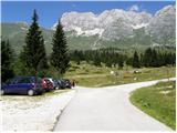
Starting point: Pecol (1510 m)
| Latitude/Longitude: | 46,40920°N 13,43760°E |
| |
Walking time: 2 h 45 min
Difficulty: very difficult marked way
Elevation gain: 920 m
Elevation difference along the route: 930 m
Map: Julijske Alpe - zahodni del 1:50.000
Recommended equipment (summer): helmet
Recommended equipment (winter): helmet, ice axe, crampons
Views: 8.016
 | 1 person like this post |
Access to starting point:
A) From Kranjska Gora over the border crossing Rateče we drive to Trbiž / Tarvisio. In Trbiž we continue left in the direction of Bovec and we follow the road to the crossroad near Rabeljsko jezero lake. Here we continue right in the direction of Nevejski preval (Na Žlebeh) / Sella Nevea. When the road already starts descending towards Reklanska dolina valley, in a sharp left turn a narrow and steep road towards Montaževa visoka planota / Altopiano del Montasio branches off to the right (by the crossroad there are signs in Italian language). We follow this road to a large marked parking lot, which is situated a few 100 m before the Pecol cheese dairy (further driving is forbidden).
B) From Bovec we drive to the border crossing Predel, from which we descend on the Italian side. Only a little after Rabeljsko jezero lake we come to a crossroad, where we continue left in the direction of Nevejski preval (Na Žlebeh) / Sella Nevea. When the road already starts descending towards Reklanska dolina valley, in a sharp left turn a narrow and steep road towards Montaževa visoka planota / Altopiano del Montasio branches off to the right (by the crossroad there are signs in Italian language). We follow this road to a large marked parking lot, which is situated a few 100 m before the Pecol cheese dairy (further driving is forbidden).
Route description:
From the parking lot on the mountain pasture Pecol we go on a narrow road which runs right towards the mountain hut Rifugio di Brazza. Soon signs point us to the left on a footpath, on which through meadows in good 15 minutes we reach the mountain hut. At the crossroad, which is only a few dozen meters above the mountain hut we go on the left path, which runs towards the saddle Forca dei Disteis (2201m), and the right path runs to Špik Hude police (2420m). From the crossroad at first we descend a few meters and then in a gentle ascent we cross meadows below the mountain walls of Montaž and if we are lucky we can also notice Alpine marmots, of which there are quite a lot around here. Soon from our left side joins the direct path from the mountain pasture Pecol, which is a few minutes shorter than this one past the mountain hut. Here the path already ascends a little steeper and soon brings us to the already mentioned saddle where there is usually a lot of ibex. To the saddle we need from the starting point a little less than two hours. At the saddle the path turns to the right over the scree and we soon come again to a crossroad. We go left on a less visited path which leads towards the bivouac Suringar, and right leads the normal easier path to Montaž.
The path then over the scree brings us into a rocky part of the path. Here the path, which is marked with red dots, becomes slightly exposed and through natural passages brings us on precipitous western slopes. Further the path crosses on a precipitous ledge towards the north. Because the fixed safety gear has been destroyed, and on part of the path there is also a lot of scree, on a short section of the path there is also a great risk of slipping. The slope which we cross then becomes less steep and brings us to a junction, where to the right branches off the path over Findenegg couloir to Montaž. At the junction we continue straight and then follows only a few minutes of easy walking to bivouac Suringar.

Photos:
 1
1 2
2 3
3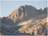 4
4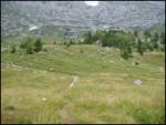 5
5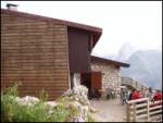 6
6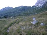 7
7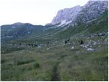 8
8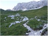 9
9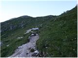 10
10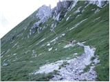 11
11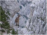 12
12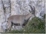 13
13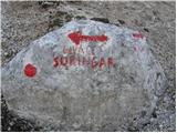 14
14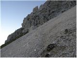 15
15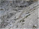 16
16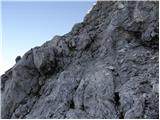 17
17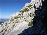 18
18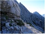 19
19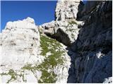 20
20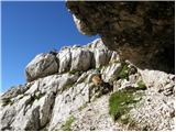 21
21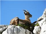 22
22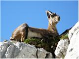 23
23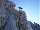 24
24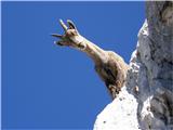 25
25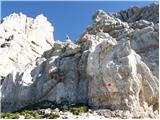 26
26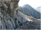 27
27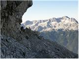 28
28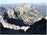 29
29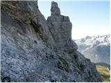 30
30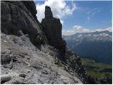 31
31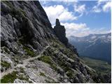 32
32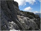 33
33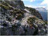 34
34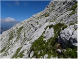 35
35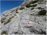 36
36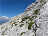 37
37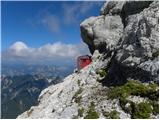 38
38
Discussion about the trip Pecol - Bivacco Suringar
To post a comment you must log in:
If you do not yet have a username, you must first
register.