Pecol - Jôf di Montasio/Montaž (via Findenegg couloir)
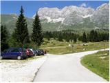
Starting point: Pecol (1510 m)
| Latitude/Longitude: | 46,40920°N 13,43760°E |
| |
Route name: via Findenegg couloir
Walking time: 3 h 45 min
Difficulty: very difficult marked way
Elevation gain: 1243 m
Elevation difference along the route: 1255 m
Map: Julijske Alpe - zahodni del 1:50.000
Recommended equipment (summer): helmet
Recommended equipment (winter): helmet, ice axe, crampons
Views: 77.544
 | 2 people like this post |
Access to starting point:
A) From Kranjska Gora over the border crossing Rateče we drive to Trbiž / Tarvisio. In Trbiž we continue left in the direction of Bovec and we follow the road to the crossroad near the Rabeljsko jezero lake. Here we continue right in the direction of Nevejski preval (Na Žlebeh) / Sella Nevea. When the road already starts descending towards the Reklanska dolina valley, in a sharp left turn a narrow and steep road towards Montaževa visoka planota / Altopiano del Montasio branches off to the right (by the crossroad there are signs in the Italian language). We follow this road to a large marked parking lot, which is situated a few hundred meters before the Pecol cheese dairy (further driving is forbidden).
B) From Bovec we drive to the border crossing Predel, from which we descend to the Italian side. Just a little behind the Rabeljsko jezero lake we come to a crossroad, where we continue left in the direction of Nevejski preval (Na Žlebeh) / Sella Nevea. When the road already starts descending towards the Reklanska dolina valley, in a sharp left turn a narrow and steep road towards Montaževa visoka planota / Altopiano del Montasio branches off to the right (by the crossroad there are signs in the Italian language). We follow this road to a large marked parking lot, which is situated a few hundred meters before the Pecol cheese dairy (further driving is forbidden).
Route description:
From the parking lot on the mountain pasture Pecol we head onto the narrow road that leads right towards the mountain hut Rifugio di Brazza. Soon signs direct us left onto a footpath, on which through meadows in a good 15 minutes we reach the hut. At the crossroad, which is only a few dozen meters above the hut, we take the left path, which leads towards the saddle Forca dei Disteis (2201m), the right path leads to Špik Hude police (2420m). From the crossroad we first descend a few meters, then in a gentle ascent we cross meadows below the walls of Montaž and if we are lucky we can also notice Alpine marmots, of which there are quite a few around here. Soon from our left side the direct path from the mountain pasture Pecol joins, which is a few minutes shorter than this one via the hut. Here the path already ascends somewhat more steeply and soon brings us to the already mentioned saddle, where there are usually many ibex. To the saddle we need from the starting point less than two hours. At the saddle the path turns right over scree and soon we come again to a crossroad. We direct ourselves left onto the less visited path, which leads towards the bivouac Suringar, right leads the usual easier path to Montaž.
The path then brings us over scree into the rocky part of the path. Here the path, marked with red dots, becomes somewhat exposed and through natural passages brings us to the precipitous western slopes. In continuation the path traverses along the precipitous ledge towards the north. Since the fixed protections are destroyed, and on a part of the path there is also a lot of scree, there is also a great risk of slipping on a short section of the path. The slope which we cross then becomes less steep and brings us to a junction, where to the right branches off the path via Findeneggov ozebnik to Montaž. At the junction we continue straight and only a few minutes of easy walking to bivouac Suringar follow.
From the bivouac we return to the junction and markings direct us left upwards. The path, marked with red dots, begins to ascend quite steeply and brings us into Findeneggov ozebnik. The ascent through the ozebnik is relatively steep and is also exposed to falling rocks. The path on this part is not secured and the larger part of the path is grade I climbing, a short section also grade II.
At the exit from the ozebnik the path becomes somewhat crumbly, so we must be careful not to trigger stones. In continuation the path brings us to an exposed ridge along which we then soon reach the panoramic summit.
We descend along the usual southern path over Pipan's ladder. During the descent over the ladder the use of self-belaying is recommended.

Photos:
 1
1 2
2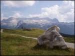 3
3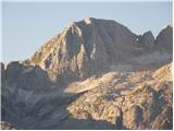 4
4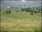 5
5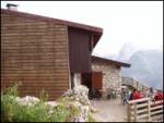 6
6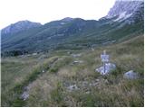 7
7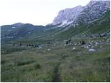 8
8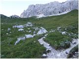 9
9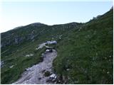 10
10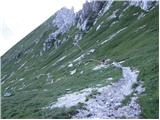 11
11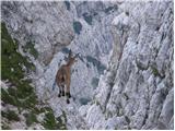 12
12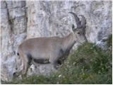 13
13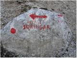 14
14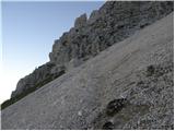 15
15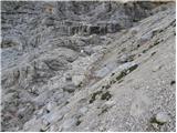 16
16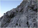 17
17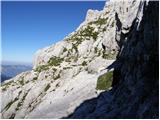 18
18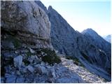 19
19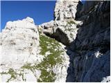 20
20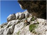 21
21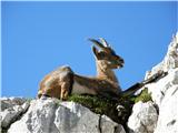 22
22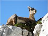 23
23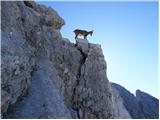 24
24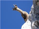 25
25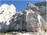 26
26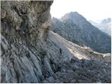 27
27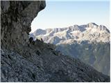 28
28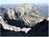 29
29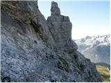 30
30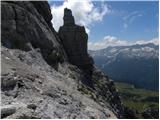 31
31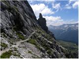 32
32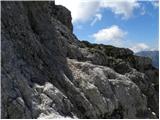 33
33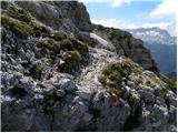 34
34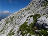 35
35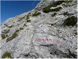 36
36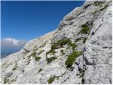 37
37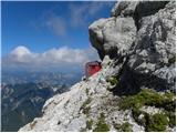 38
38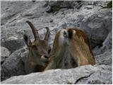 39
39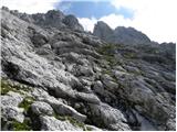 40
40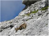 41
41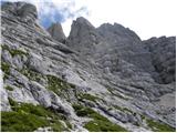 42
42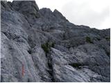 43
43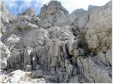 44
44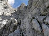 45
45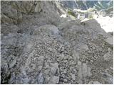 46
46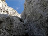 47
47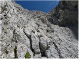 48
48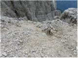 49
49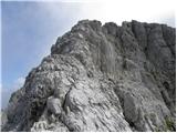 50
50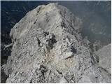 51
51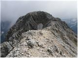 52
52 53
53
Discussion about the trip Pecol - Jôf di Montasio/Montaž (via Findenegg couloir)
Show older messages
|
| andrej783. 08. 2011 |
Climbed the glacier yesterday, still lots of snow in it, climbing difficulty increases towards the top and reaches 3- in places. Took 1 hour for the glacier route, total to summit good 3 hours. No protection whatsoever on this path. The chimney at the glacier exit and transition to the very exposed summit ridge is also quite difficult (without protection too).
|
|
|
|
| ben3. 08. 2011 |
This is really interesting. About two years ago it seemed to me that in the glacier there is some grade II (easy), and I apparently missed that exit chimney too, because I almost walked to the ridge. Yes, I'll have to check it again!!! 
Best regards B
|
|
|
|
| IgorZlodej3. 08. 2011 |
In my opinion they turned into the right gully, where there might still be snow, Findenegg has no exit chimney.
|
|
|
|
| andrej783. 08. 2011 |
Yes, we turned into the right gully, into which you turn about 10 minutes before bivouac Suringar. Also mention the falling rocks which the climber ahead of us dislodged from the top, a shrapnel the size of a walnut flew into my head, the helmet did its job.
best regards
|
|
|
|
| Matjaz_6513. 08. 2011 |
a few more of my photos ... from the ascent through Findenegg Glacier ... and descent via Pipan Ladder 
|
|
|
|
| janezn27. 08. 2011 |
I'm curious about the markings on the path through Findeneggov ozebnik - compared to the path via ladder - if they are better or worse, or if it's possible to get off track - thanks for the reply
|
|
|
|
| Matjaz_6528. 08. 2011 |
Markings are along the entire path ... but they are quite faded and not very visible 
you can definitely follow them ... but in case of inattention some path can lead you astray 
so be careful ... if you don't see them you're definitely on the wrong path ... which you'll have to return from and find them
you can look at my photos on the link above ... from 25 onwards it's the path through Findenegg 
|
|
|
|
| andrej7828. 08. 2011 |
Matjaž really nice photos, from the glacier photos I conclude that you went through the left gully? how was it with falling rocks?
|
|
|
|
| Matjaz_6528. 08. 2011 |
I don't know if it's the left gully or some other ... as far as I saw only one path is marked ... which we followed
no falling rocks ... but it's true that we didn't see anyone in the glacier ahead of us ... definitely wouldn't go through it without a helmet
|
|
|
|
| francoz14. 10. 2011 |
Hey folks,
does anyone know the current conditions on the glacier?
|
|
|
|
| Matjaz_656. 08. 2012 |
some photos from the Špik Hude police path - left ferrata - Findenegg glacier - Montaž
|
|
|
|
| borut197424. 09. 2012 |
22.9. was on this path to Montaž conditions good path ok but need to be careful
|
|
|
|
| ms_primoz25. 09. 2012 |
borut1974 - it was awesome on 22.9. right Borut? you'll get the pics...
|
|
|
|
| ljubitelj gora11. 07. 2013 |
Last year I went up this path, it was already close to noon and so in the Ozebnik I waited like on the front line, stones from small to large kept flying down all the time. We all hid like squirrels. I started the tour solo, but met other hikers in Ozebnik. I only caught up with the culprits triggering the stones just below the summit. After reaching the summit, rest followed and after rest, departure back to the alpine pasture. I descended slowly towards the lojtra, but there I heard the others returning from the summit and took a few more minutes of rest and let them go ahead so they went first through the lojtra before I experienced front 2 again. Normally everything was in fog so they triggered stones on each other before the start of the lojtra. The "fun" was deep down there when the stones arrived the most and shouting at us up there. And as the last one, I went in peace without experiencing the front. The descent through the scree was still waiting, a few minutes the others were ahead of me, then I caught up and quickly descended to the pasture as I was already somewhat tired from the nighttime Mangart. Some more pictures here: https://picasaweb.google.com/114400986607884783562/Montaz?noredirect=1
|
|
|
|
| Bojan_A9. 08. 2013 |
Is there still any snow in the glacier this year?
|
|
|
|
| Jany9. 08. 2013 |
No. There is no snow in the glacier. Checked yesterday!
But there is a forest fire near Pecol, which they hadn't managed to contain by yesterday and everything is "smoky".
I already wrote this in "current conditions".
LP
|
|
|
|
| janez.novak9. 08. 2013 |
I've gone up the ladder twice, and there were no stones - true though, I went during the week and early, when the Italians are still sleeping.
|
|
|
|
| superoxide28. 08. 2013 |
Here is a short video of the ascent to Montaz. We ascended via the glacier and descended via Pipan Ladder. Personally, this is one of my favorite circular trails. Quite adrenaline-packed and not too long a tour. http://www.youtube.com/watch?v=8s5fMfiNqXY
|
|
|
|
| monika6914. 08. 2014 |
But who knows if there's still snow in the glacier?
|
|
|
|
| seatibiza0114. 08. 2014 |
There's no more in the glacier. On Sunday there were only two short snow patches lower down, which we crossed without issues.
|
|
|
|
| afurla1127. 09. 2014 |
Yesterday we went this way-highly recommend wearing a helmet, as a lot of falling rocks fly. The path is very poorly marked.
|
|
|
|
| sercv0728. 09. 2014 |
@afurla11,
is there still any snow on the path through Findeneggov ozebnik?
|
|
|
|
| ajo6225. 08. 2016 |
To all who descend via the Pipan ladder, I recommend instead descending via the old path that bypasses the ladder further along the ridge above the north face. The few-meter-long ledge above the 1000-meter drop is very adrenaline-pumping, although there are no difficulties. Then the path zigzags down the southern slope to the entrance to the Pipan ladder. This way we avoid falling rocks and also don't endanger others ascending the ladder. Otherwise, the path is a bit more dangerous when wet (which certainly also applies to the Pipan passage).
Best mountain greetings to all!
|
|
|
|
| bite29. 08. 2016 |
For me the path via Findenegg glacier wins, the beauties of the mountains as you see them outweigh every drop of sweat, right my dear Marija otherwise very nicely spent last Thursday.
|
|
|
|
| redbull29. 08. 2016 |
Did you mean ascent via Findenegg glacier or perhaps descent? Descent via the glacier is very difficult in current conditions. I completely agree with Ajo 62, I really don't know why they push so much on the ladder when the passage is much nicer to the right of it.
|
|
|
|
| robi143. 09. 2016 |
@Redbull and @ajo62...
Could you perhaps describe the old path along the Pipan ladder a bit more precisely?
Next weekend I plan to go to Montaž and I'm very tempted by the circular path Findeneggov ozebnik and the old descent, then continuing to the end of Poliški špiki.
Is the path towards bivouac Suringar in any better condition than described in the above entries?
|
|
|
|
| redbull4. 09. 2016 |
Instead of going down the ladder, just continue along the ridge for about 100m. It's marked. Then it turns down, no difference, especially for someone who isn't good at clipping onto the via ferrata set, this path is great.
|
|
|
|
| malimiha16. 06. 2017 |
Hi. Has anyone been this year across the glacier? Is it bare? And the left via to the spire?
|
|
|
|
| lynx16. 06. 2017 |
From afar it didn't look bare, but I didn't see it directly.
|
|
|
|
| natasa si17. 06. 2017 |
I only went to Montaž, via Pipanovo. I'd say there's only still some snow under the lojtra, which causes a bit of trouble and slippery at the end. If winter gear no longer fits in the backpack, wait a day.. cows aren't up there yet either
|
|
|
|
| janez.novak17. 07. 2017 |
Today I headed to the Western Julians, namely to Montaž. From Planina Pecol I went to Škrbina vrh Strmali, then towards Bivak Suringar and to the summit via Findenegg glacier, descent via Pipanova lestev. Markings on the path are quite good for Italian standards. The path from Torre Disteis via Velika polica is now fine (new fixed cables) and fixed rope in one place. Through the glacier the path is nicely routed, plenty of handholds and footholds. The most demanding is the rock jump (in description pic no.47). I tried to go through the little chimney, but it didn't work. Bypass on the left was too dangerous due to smooth rock; then I pushed the backpack up and climbed up not in a very elegant style. Above the glacier one must watch out not to dislodge rocks onto hikers. The path overall very nice. And also: at the start of Pipanova lestev one cable is torn off, so one peg needs to be jumped over.
|
|
|
|
| cotro429. 07. 2017 |
Today up to the chimney nothing special, then like janez.novak I drop my backpack and somehow scramble over it, and just before I reach the edge one annoying detail. To the ladder completely slippery steps in places, at least 15 of us crowding on the ladder, somewhere in the middle a torn bracket, and the banging of one of our families without helmets in sneakers with a child over the ladder no comment...
|
|
|
|
| maregol29. 07. 2017 |
You go too late, that's why you have crowds of poorly equipped people!!! I was alone today also on Montaž, at 9:00 when I went down via Pipanova ladder there was still no living soul... on the Leva via ferrata none either.
|
|
|
|
| redbull30. 07. 2017 |
I don't think you need to climb the ladder anymore. Right before the ladder there's a nice path that leads to the top of it. Of course, swinging on the chain is much more fun
|
|
|
|
| Ksandi14. 10. 2019 |
Yesterday my colleague and I ascended Montaž from Pecol via Leva path and over Pipanova lestev, descent via Findeneggov glacier. Unforgettable, especially the last part of the path, i.e. descent. Since I'm no longer in my prime, quite strenuous..., but beautiful
|
|
|
|
| AnteP15. 12. 2019 |
Does the snowplow ever clear that road to Pecol?
|
|
|
|
| djimuzl15. 12. 2019 |
No, you'll have to go up on foot or on skis.
|
|
|
|
| andraja9. 08. 2021 16:06:30 |
Has anyone gone through F. glacier in the last few days, is there still any snow?
|
|
|
|
| s52dg9. 08. 2021 21:11:23 |
no more snow. I was there on Friday 6.8.
|
|
|
|
| SimonT19. 06. 2022 19:15:38 |
Up and down through Findenegg glacier. The path via Pipan ladder is currently CLOSED (18.6.2022). The ridge too. Guys are thoroughly renovating the protections. Through the glacier it's really well marked. Some ropes help, especially on descent. Rocks fly like on the front line and it's not very pleasant. The best reward is the scree on descent. Probably I'll write it off as ski touring
|
|
|
|
| 2061alessio20. 06. 2022 20:14:11 |
The chief of GRS from Trbiž told me that immediately after the closure announcement he sent a team to temporarily install ropes in the Findenegg section because it's not quite easy on descent.
|
|
|
|
| SimonT21. 06. 2022 19:14:21 |
"2061alessio" good comment. Maybe someone else will report when the works are finished. For someone for whom the path via Pipan ladder is at the limit of abilities, the turn into Findenegg glacier can already be too much. Then helicopters buzz all around
|
|
|
|
| haridautovic27. 06. 2022 18:38:51 |
26.6.2022/Checked, the works on Pipanova will continue until 15.7.2022, yesterday I did the ascent via Findeneggov ozebnik, and they have really placed some ropes in places, nevertheless this trail requires much more than that for less experienced hikers. From the top I went to check the ridge to Pipanova ladder. All cables newly installed, in between some pegs to Pipana. Also the continuation of the ascent from Pipana is somewhat changed and does not go over scree but
directly up under the rocks. Very nice. Currently installing the ladder, old Pipan already cleared and goes to scrap. So as not to go back to the top, descend along the ridge towards the hilltop and down steep grass under Pipanova ladder to Pekola.
|
|
|
|
| alen9210. 07. 2023 12:36:34 |
The path via Findenegg glacier is snow-free. Recommend wearing a helmet, as there is a lot of falling rock (due to “clumsy” hikers  ). On descent via Pipan ladder we had to cross some snowfields, but doable without major issues. ). On descent via Pipan ladder we had to cross some snowfields, but doable without major issues.
LP
|
|
|
|
| akavka2. 09. 2023 15:10:54 |
Tilen, through the gully it went quite well, you probably had concerns because you, I assume, just there strayed a bit off the path and came too low. The marked path is (speaking from the ascent perspective, not descent), far right, along the wall, about 3-4m above the gully. Otherwise it also goes through the gully, but yeah, a bit harder. Safely arrived down, despite the surprised comments of hikers who waved her to the top. Probably not common practice to choose this path for descent.
Good luck
|
|
|
|
| LISAC23. 07. 2025 09:17:03 |
Hi.
Does anyone have information about snow patches in the glacier? Thanks
|
|
|
|
| funnyboy23. 07. 2025 17:31:01 |
They wrote that it's snow-free.
|
|
|
|
| LISAC23. 07. 2025 19:46:16 |
|
|
|
|
| Jeanb11. 08. 2025 08:57:14 |
Hello.
I'm interested in a comparison of Findenegg glacier with some of our ascents. My wife and I plan to ascend via this glacier. From experience we have Mrzla gora - From the hut below Rinka waterfall, Prisojnik - Kopiščarjeva path, Mojstrovke, Ojstrica - Kopinškova path, Kočne, ... . Thank you in advance for your answers and help.
LP
|
|
|
|
| mirank11. 08. 2025 10:35:51 |
Comparing routes is an ungrateful task, but if I have to, it's closest to M mountain, because there are almost no fixed protections. The ascent through the glacier itself is nothing special; at least for me, there are a couple of more exposed spots on the accessible traverse towards Suringar. Helmet mandatory and caution on the ascent above the glacier and along the ridge because it's quite loose—at least in this section, a bit similar to Kočne.
Steady footwork and good luck
|
|
|
|
| Jeanb11. 08. 2025 12:33:12 |
Many thanks for the reply.
Best regards
|
|
|
|
| LISAC11. 08. 2025 12:50:45 |
Jeanb, I was there on Friday 8.8. up via Findenegg, down via Pipan ladder. The glacier seemed normal and great but only for ascent, descent would be much harder due to scree on the rocks, the higher you go the more there is so you really trigger something quickly. The earlier you start the better. I was at 8 a.m. from the glacier on the ridge which was already in the sun. Great tour, good luck!
|
|
|
To post a comment you must log in:
If you do not yet have a username, you must first
register.