Pišnica - Špik (via Kačji graben)
Starting point: Pišnica (870 m)
| Latitude/Longitude: | 46,46880°N 13,78330°E |
| |
Route name: via Kačji graben
Walking time: 4 h 40 min
Difficulty: difficult marked way
Elevation gain: 1602 m
Elevation difference along the route: 1602 m
Map: TNP 1 : 50.000
Recommended equipment (summer): helmet
Recommended equipment (winter): helmet, ice axe, crampons
Views: 171.297
 | 10 people like this post |
Access to starting point:
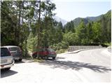
First we drive to Kranjska Gora, then continue driving in the direction of Bovec. Just a little after the Jasna guesthouse, we come to a bridge over the Pišnica river, next to which we park at a small parking lot. We can also park a few 10 meters back at a larger parking lot next to the TNP sign or near the former Hotel Erika.
Route description:
From the bridge over the Velika Pišnica we continue in the direction of Koča v Krnici, where the path leads us along a macadam road, which then runs through the valley of the Velika Pišnica. The fairly gentle road, which runs along the mountain stream, first crosses several torrents, then after the dam, which is quite photogenic due to the high mountains in the background, a little further it takes us to a marked junction, where the path through Kačji graben to Špik branches off to the left.
We continue in the mentioned direction (straight to Koča v Krnici).
The path from the junction onwards leaves the road and initially ascends through overgrown forest, higher up it crosses the lower part of the mentioned ravine and then climbs steeply. The ascent along Kačji graben is very steep and especially dangerous for slipping when wet, and we are helped by some fixed aids. The path then becomes somewhat easier and enters a dense forest, through which we ascend to an altitude of approximately 1600 m. The forest then becomes sparser and the path brings us to the foot of mighty scree slopes. When we climb up to the scree the path turns slightly to the left and begins to ascend through the gravelly world of scree. Walking on the relatively steep scree takes quite a lot of energy.
Higher up the path turns to the right, crosses a gully exposed to falling rocks and then brings us into a smaller cirque between Špik on the left and Lipnica (on some maps also marked as Liprtica) on the right. Here the path levels out for a short time and in the next few steps brings us to the place where the path via Grunt or the path via Lipnica joins us.
Here we continue left, along the path that climbs very steeply along the summit slope of Špik, there are no fixed aids on this section. After about 15 minutes of walking along the summit slope, over which we climb through broken rock, we reach the panoramic summit.
In the last part of the path there is a very high danger of falling rocks.
Trailhead - turnoff for Kačji graben 0:40, turnoff for Kačji graben - junction below the summit of Špik 3:45, junction below the summit of Špik - Špik 0:15.

Along the route: Eriški most (852m), Rušev graben (899m), Odcep za Kačji graben (916m), Razpotje pod vrhom Špika (2401m)
Photos:
 1
1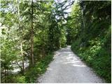 2
2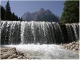 3
3 4
4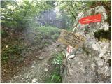 5
5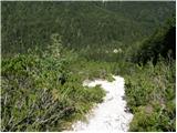 6
6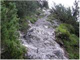 7
7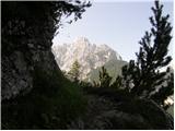 8
8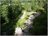 9
9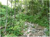 10
10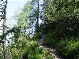 11
11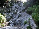 12
12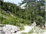 13
13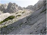 14
14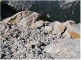 15
15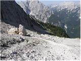 16
16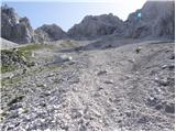 17
17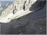 18
18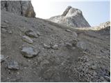 19
19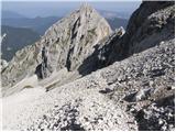 20
20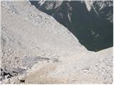 21
21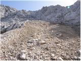 22
22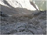 23
23 24
24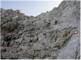 25
25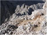 26
26 27
27
Discussion about the trip Pišnica - Špik (via Kačji graben)
Show older messages
|
| majdicst13. 02. 2007 |
I did this path downhill and it seems more unpleasant to me than the one from Krnica. Wet rocks covered with branches at 100% incline.... And it draaaaaaaaags on. And it draaaaaaaaags on. The path from Krnica is much nicer. The path from Krnica is much nicer.
|
|
|
|
| BOSTI29. 07. 2007 |
very difficult route, much nicer from Krnica.
|
|
|
|
| Gost4. 08. 2007 |
The path in the opposite direction is much nicer and easier. The claim of course doesn't hold for scree lovers (uphill).
|
|
|
|
| Gost4. 08. 2007 |
I'm not a scree fan, but the scree on the path through Kačji graben is the lesser evil for me. Namely, I have trouble walking exposed sections (views into the depths) so the path from Krnica (though I believe it's nicer) is not an option for me. I'd rather choose safer knee-grinding on scree.
|
|
|
|
| michael664. 09. 2007 |
The path from Krnica isn't that exposed.
Up from Krnica, down through Kačji graben. What could be nicer.
|
|
|
|
| hostar6. 09. 2007 |
From Krnica upwards it drags on, you see the summit several times, but it's never the right one.I'd rather push through Kačji graben and return towards Krnica.
|
|
|
|
| Gost22. 09. 2007 |
I did a loop, but forgot to go to the summit!
Up I went through Kačji graben and at the spot where paths join turned right. When I realized the mistake I didn't bother to go back. Špik, I'm waiting for you!!!
|
|
|
|
| Virenque8. 07. 2008 |
So it would be good to change the difficulty to "Very demanding", so as not to mislead.
|
|
|
|
| Nickster22. 07. 2008 |
They say EXTREMELY DEMANDING AND ANNOYING PATH!!!
|
|
|
|
| Nickster22. 07. 2008 |
Otherwise it's really nice up there
lp
|
|
|
|
| fpetel124. 07. 2008 |
Personally, I'd say demanding (not very demanding) path. The safety gear in the lower part is very welcome but it could somehow be done without, although it's steep and slippery. Last year we went after rain and it was okay - carefully!
|
|
|
|
| Nickster24. 07. 2008 |
"fpetel" yeah you're right. A bit too confident
|
|
|
|
| Bojan_A22. 08. 2008 |
I went almost exactly a year ago up through Kačji graben and down through Lipnica. It seems to me that in the opposite direction it would be much nicer to scramble through the scree. But I went this way because in the morning I didn't feel like walking an hour on the road to Krnica.
http://xrl.us/on82y
|
|
|
|
| mvolk28. 09. 2008 |
Today my colleague and I were on Špik. Parked at the 3rd serpentine, descended lower to the start of Kačji graben and ascended via it to Špik. In the morning it was quite cloudy despite forecasts, above 2000m it was snowy but not freezing. A bit more caution and it went without problems. At the summit unfortunately no views. We descended towards Krnica and after just under half an hour of descent were rewarded with wonderful weather and views. Choosing the ascent via Kačji graben and a very scenic descent to Krnica seemed a good decision to us. Otherwise a matter of mountaineering taste.
|
|
|
|
| proplayer1118. 08. 2009 |
So is this path demanding only because of walking on scree?
|
|
|
|
| Bojan_A8. 08. 2009 |
On the path through Kačji graben there are some pegs and bolts, but nothing special. From the other side via Golica it's harder.
|
|
|
|
| proplayer1118. 08. 2009 |
How demanding is this path compared to the path to Razor from Zadnjica.
|
|
|
|
| andrejjerina9. 08. 2009 |
To me personally, the route seems easier than to Razor. On Razor you have some exposed sections, on the way to Špik, though, nothing seemed too serious to me. Maybe the path through Kačji graben drags on a bit, but it's worth it! LP Andrej
|
|
|
|
| vertov1. 09. 2009 |
Today I completed the tour through Kačji graben. I have to say it's one of the more boring ones I've done. First the path through the forest and as soon as you emerge onto the clearing, you spot the scree that accompanies you all the way to Špik. Probably no need to emphasize that on the scree the feet suffer greatly and burn.
Anyway, the whole experience pays off with the view from Špik, which is really magnificent, and the descent on the scree, where you gain a lot so the path to the valley doesn't drag at all.
From the parking lot to the summit of Špik I needed 2.5 hours.
|
|
|
|
| v.blazins2. 09. 2009 |
in the mountains you have to enjoy, I was on every mountain in the hiking log at least 3 times and always arrived back to the valley on time within the limits for the ascent
|
|
|
|
| vertov2. 09. 2009 |
Where does it say that if you step a bit more on the gas, you don't enjoy it?
Personally, I suffer much more if I have to walk slowly and adjust to the rest of the group. At my constant pace, I don't feel like I'm rushing at all. I have a very long stride (when others make 1.5 steps, I make one), I'm quite lean, and I don't stop during the hike. Apparently, that's the recipe to halve the 'official' time. And on the way, I don't miss anything that other hikers see.
Anyway, not everyone goes to the mountains with the same goal. Why does the Grintovec race exist then? Probably not to observe nature and pick flowers along the way.
Some just want to combine mountain hiking with a good sports achievement.
|
|
|
|
| rl138824. 06. 2010 |
Has anyone been to Špik recently, is there any snow left?
|
|
|
|
| skokec11. 07. 2010 |
Yesterday I also hiked Špik..
From Krnica up and down through Kačji graben. If the path takes me to Špik again, I'll definitely go in the opposite direction. As for time, it's like this - 4 hours is quite realistic - more rather than less. Anything under that time borders on sport
|
|
|
|
| skokec11. 07. 2010 |
Ps-At the entrance from the road into Kačji graben there is a warning sign that passage through Kačji graben is difficult.. That passage is a small problem.. the slope is much more strenuous.
|
|
|
|
| NejcJ24. 09. 2010 |
The path seems more suitable for descent to me, it drags on. From the cirque the path is much more varied and interesting.
|
|
|
|
| goba122. 08. 2011 |
Today I was on Špik and we did the descent through Kačji greben. The descent is very fast (less than 2 hours) but I don't recommend the ascent path because of the long scree..
Best regards
|
|
|
|
| dedo2422. 11. 2011 |
Has anyone been to Špik recently, via Kačji graben or from Krnica? How is it regarding snow?
|
|
|
|
| barbara.hribi18. 06. 2012 |
On Saturday (16.6.) I was on Špik. Up through Kačji graben, down towards Krnica. Tiring , but beautiful. The path through Kačji graben was almost better for me, because the return via Lipce (towards Krnica) dragged on forever , but beautiful. The path through Kačji graben was almost better for me, because the return via Lipce (towards Krnica) dragged on forever . It's also much better marked (newly) through Kačji graben than towards or from Krnica. Overall, a very good tour! . It's also much better marked (newly) through Kačji graben than towards or from Krnica. Overall, a very good tour!
Yes, up on the screes (path through K.g.) there was still some snow, but it was easily passable without crampons... I was surprised that there were so few hikers (we met only about 5). Probably "everyone" was at the gathering in Kranjska Gora, ha ha...
|
|
|
|
| malimiha26. 07. 2012 |
I need advice, specifically which path you recommend to go up to Špik and then which one down. Thanks for the info.
|
|
|
|
| jax26. 07. 2012 |
Via Lipnica in both directions. Kačji graben is only for masochists.
|
|
|
|
| malimiha26. 07. 2012 |
What because of scree? Otherwise it doesn't bother me that much. What about up Kačji graben and then down Lipnica?
|
|
|
|
| jax26. 07. 2012 |
No, not because of scree. The thing is, from the top of Špik to Pišnica it's about 1500 meters of descent. Of that, the top 100 are on rocks (shared by both paths anyway), the next 200 on scree (super there). Then follows 1200 meters of horribly steep gully where the path doesn't ease up even for a step. You just have to scramble down here - actually too steep for normal walking, poles almost unusable, and it's not climbing either. The worst possible. And in the lower part, when you're already fed up, steep gullies follow. And the whole thing is completely exposed downward the entire time so you don't have a single relaxed step all the way to the road. Really - nothing but cursing, don't recommend.
|
|
|
|
| LidijaJesih26. 07. 2012 |
jax, now you're scaring him. It's not that bad, though... Everyone has a subjective opinion. I usually tackle the path up Kačji graben and down Grunt. The path through the gully is really steep, when wet it can be slippery like a snail, but for going up it's fine, and in the shade maybe a bit longer. For down, the beautiful one through Grunt, when legs are tired, eyes enjoy. I've also gone the other way, and it was really less pleasant, especially because of sliding on mud-rock combo. If you like loops, this circle is totally fine.
|
|
|
|
| malimiha26. 07. 2012 |
Thanks for the advice.
I'll think a bit more about which variant we'll choose on Saturday.
|
|
|
|
| Daaam26. 07. 2012 |
I also recommend up and down via Lipnica ... Kačji graben got on my nerves...
|
|
|
|
| Flora126. 07. 2012 |
Hehe, I don't like Kačji graben either and I've already been thinking what to do, because I want to combine Špik with Frdamane police.
|
|
|
|
| turbo26. 07. 2012 |
Flora1,
up via Lipnica, descent under Frdamane, ascent onto them, then grit your teeth a bit (that is, endure) and down Kačji.
The more you suffer down Kačji, the better the cooling of your feet in the cold Pišnica feels afterwards.
|
|
|
|
| LidijaJesih26. 07. 2012 |
You need a bit of a sense for masochism.
|
|
|
|
| stargojzar26. 07. 2012 |
Why not first to Frdamane, then the tour will be nicer.
|
|
|
|
| Sam.volk26. 07. 2012 |
Both paths to Špik are wonderful. Lp
|
|
|
|
| turbo26. 07. 2012 |
Grit your teeth and endure. If it doesn't help, grit harder and endure. . . . . .
In short, the tighter you grit the more you suffer.
I mean when I think of Kačji. Going up.
|
|
|
|
| zvone127. 08. 2012 |
Does anyone know if there is now a stamp at the top of Špik?
|
|
|
|
| skalaš7027. 08. 2012 |
I was up there on 28.7 and the stamp was there where it belongs!
Regards and safe steps.
|
|
|
|
| zvone128. 08. 2012 |
Skalaš, thanks for the reply.
LP!
|
|
|
|
| skočnik123. 08. 2013 |
Are both paths snow-free?
|
|
|
|
| don Sergio3. 08. 2013 |
You can hike both paths without stepping on snow.
|
|
|
|
| skočnik123. 08. 2013 |
one more question: is this path very exposed in the summit section? (is it for those with vertigo?)
|
|
|
|
| don Sergio4. 08. 2013 |
The path doesn't seem exposed to me, because it's not precipitous, so I think it's not too demanding for those afraid of heights. In the summit section, you need to use your hands on the rock, because there are no fixed protections. Regarding "heights", the other path from the hut in Krnica is more exposed.
|
|
|
|
| stropci2. 07. 2014 |
Is there still any snow on this trail?
|
|
|
|
| funnyboy2. 07. 2014 |
There are definitely still snowfields on the scree. The summit part over rocks is clear.
|
|
|
|
| LunaMars13. 07. 2014 |
Can it already be done without crampons and ice axe?
|
|
|
|
| Gregorvu22. 10. 2014 |
Does anyone know what the current conditions for ascent are like??
|
|
|
|
| JusAvgustin22. 10. 2014 |
There is snow in Tamarju. Now judge for yourself.
|
|
|
|
| Gregorvu29. 10. 2014 |
Will it be okay to go tomorrow??
Is there any snow??
|
|
|
|
| Rokson29. 10. 2014 |
Tomorrow, on Thursday I'm going to Špik. Snow up to approx. 10-15cm (except in shady spots). I'll take crampons. Expecting good conditions. If there's any surprise I'll turn back.
|
|
|
|
| zdenkok29. 10. 2014 |
Thanks for the info, I'm also leaving on the same path on Thursday morning.
|
|
|
|
| Gregorvu31. 10. 2014 |
If anyone planned to go up on Thursday and didn't go, they can regret it.
The weather was fantastic, the view phenomenal..
|
|
|
|
| malimiha15. 06. 2015 |
Hi
I'm interested if the path through Kačji graben and the path past the koča in Krnica are dry? Thanks and best regards, Miha
|
|
|
|
| Potohodnik15. 06. 2015 |
A little below the summit there are snow patches which you can avoid without problem. Both paths are completely passable without winter gear.
|
|
|
|
| Stefano916. 08. 2015 |
Hi,
has anyone been to Špik this year?
Is the path nice without pitons or any ferrata?
Can't see anything from the pictures, just want to be sure hehe
Thanks for the answer
|
|
|
|
| BlackDiamond23. 06. 2016 |
Is this path suitable for those afraid of heights?
|
|
|
|
| garmont23. 06. 2016 |
The path described above is nowhere particularly exposed, so it is suitable for those who have issues with depths.
You only need to be careful a little below the summit, and even there the path skilfully avoids the precipices.
Best regards
|
|
|
|
| Sašek13. 07. 2016 |
Very nice panoramic and undemanding one-day tour. LpS
|
|
|
|
| kowachko23. 07. 2016 |
Today via Kačji graben for the first time to Špik. Really nice high mountain excursion!
The path has no flat section, doesn't let up. When you finish with the forest you reach scree, where the test of will and endurance really begins. 
But it is technically undemanding and pleasant in the shade, ideal for summer mornings and forenoons.
The view when you reach above the tree line is also nice - Prisank, Mojstrovke, Jalovec, Mangart...
|
|
|
|
| zmp217. 02. 2017 |
Yesterday to Špik via Kačji graben, dry snow 20-40cm all the way, made a track, conditions excellent.
|
|
|
|
| to68ne5. 08. 2018 |
Hello.
Next week I would go with my daughter to Špik, I would like to do a circular path, so I'm interested if someone can advise which path is better to go up and which back.
thanks for the answer and help
Regards, Tone
|
|
|
|
| damjan8627. 06. 2019 |
Hello!
today I visited Špik via Kačji graben. The path is super up to the scree fields. Before the scree fields you cross a gentle snowfield where there are no problems. After approx. 20 min scrambling on scree and after a right turn I again reached a snowfield (the path goes across the snowfield), where I would definitely need crampons/ice axe. The snowfield can be bypassed with a bit of climbing on the right side. Then another snowfield follows, which can again be avoided on the left side (across scree with quite large stones). To the summit it's then a nice path. For descent both problematic snowfields can be bypassed on the right side across scree.
Given the extent of the last two snowfields I believe they will remain until August. Until then this path will be quite physically demanding, mainly due to the bypasses and ascending paths that go over scree.
In any case, it is essential to do the ascent in the morning. On the way back the sun was already burning my back for pop... and the time was between 9 - 10 a.m.
Best, Damjan
|
|
|
|
| ločanka13. 07. 2019 |
For me, not only the summit is beautiful, but also the trail from there on, when you come out of the forest and stop at a really idyllic spot by the larch with the marker, somewhere around 1800 m. Already because of this place, the trail is worth it, as you can't just continue. It would be worth it even just to there,
|
|
|
|
| darinka423. 10. 2019 |
Yesterday we decided on descent through Kačji graben. The trail was dry. No damp rocks in the forest. But it's quite long. Wonderful view of larches which are already losing needles. But colours still beautiful especially in sun as we descended. And lots of foliage on last part of trail where you had to be even more careful. Descent on scree quite solid. Probably a bit harder for ascent.
|
|
|
|
| Lenore3. 10. 2021 20:36:22 |
I went up via Krnica, down via Kačji graben.. and if I had to choose again, I'd go down via the Krnica hut too (even though it wouldn't be circular).
Kačji graben is great for descent as long as there's scree.. but when the scree ends.. it's horribly steep through the forest, rocks slide, roots slide, long and unpleasant path for descent there.
But I can't imagine going up there (because of the scree).
|
|
|
|
| Barb1235. 03. 2026 06:52:17 |
Has anyone maybe been to Špik? I'm interested in the conditions.
|
|
|
|
| Nehodimvhribe5. 03. 2026 13:35:58 |
@darinka4. Can you copy/paste or summarize what's written? Miran Mohorcic doesn't want to share the post with everyone. Thanks.
|
|
|
|
| darinka45. 03. 2026 18:54:23 |
I can tell you what Miran Mohorčič wrote to me. On Sunday it was trodden. What wasn't trodden, they trod it. There were no major problems. You need to be early. Especially because of the snow below the summit, where there is 20-30 cm. Regards.
|
|
|
|
| Nehodimvhribe7. 03. 2026 18:47:56 |
Conditions on 7.3.:
There's a track, path traceable.
Snow was so-so, good in places, worse in others, it melts quickly lower down as far as snow goes.
Last ascent to the summit excellent.
Weather great, shade is good so it's not too hot, sun on top, but it was blowing unpleasantly.
Met 12 people in total, started from Erikine's bridge at 5am
Recommend
|
|
|
To post a comment you must log in:
If you do not yet have a username, you must first
register.