Planina Blato - Bela glava
Starting point: Planina Blato (1147 m)
| Latitude/Longitude: | 46,31120°N 13,85010°E |
| |
Walking time: 3 h
Difficulty: easy pathless terrain
Elevation gain: 779 m
Elevation difference along the route: 810 m
Map: Triglav 1:25.000
Recommended equipment (summer):
Recommended equipment (winter): ice axe, crampons
Views: 8.426
 | 2 people like this post |
Access to starting point:
From the Ljubljana-Jesenice motorway, take the Lesce exit and follow the road towards Bled and further towards Bohinjska Bistrica. Continue driving towards Lake Bohinj (Ribčev laz), where we reach a junction, continuing right towards Stara Fužina. In Stara Fužina, at the junction by the chapel, turn sharply left onto the ascending road towards Planina Blato, Planina Vogar and Voje Valley. The road then takes us to the toll and parking fee collection point, but we follow it further to the next junction, where we continue left (right to Voje). Then follow the road to the next junction (it takes quite some time), where we turn sharply right towards Planina Blato (straight to Planina Vogar). Follow this road to the parking lot above Planina Blato.
Route description:
From the parking lot at Planina Blato, head slightly back along the road to the signposts at the cart track. Here, take the cart track, which first ascends steeply then moderately, bringing us to a junction in ten minutes of walking, where we go left (straight to Planina v Lazu). Follow the cart track through the forest all the way to Koča na Planini pri Jezeru. Here, a view opens to the surrounding hills. Bypass the mountain hut on the left and the path leads us in a slight descent to a junction, where we continue straight on the cart track (left to Planina Viševnik). The mostly rocky cart track, running through an indistinct valley, ascends steeper several times and after half an hour of walking from Planina pri Jezeru brings us to Planina Dedno polje, where we reach the next junction.
Continue towards Planina Ovčarija and after about half an hour of walking reach a less visible crossroads, where a path branches left directly to the shepherd huts at Planina Ovčarija. Just after this junction, notice a small meadow on the right side of the path. Here, leave the marked path and head right. There is also a small cairn by the path. If you cannot find the branch, you can continue on the marked path towards Mala Tičarica and then at the foot of Mala Tičarica descend right into the valley between Bela Glava and Tičarica. If you successfully found the branch, head across the meadow and then into sparse forest. Here we mostly walk off-trail, only in a few places on a faintly visible path. When the forest ends, continue along the narrow valley not overgrown with dwarf pines. This valley nicely leads past the dwarf pines and brings us to the meadow between Bela Glava and Mala Tičarica. Continue across the meadow northwards and just before the end of the meadow notice a narrow path sharply right through the dwarf pines. At the beginning, try to keep to the north-western slope of the mountain, then a bit below the summit cross the western slopes and reach the summit from the south side. Bela Glava is overgrown with dwarf pines on all sides and rarely does anyone manage to get through the system of labyrinths without climbing through the dwarf pines.
Starting point - Planina pri Jezeru 1:00, Planina pri Jezeru - Planina Dedno polje 0:30, Planina Dedno polje - Bela glava 1:30.

Photos:
 1
1 2
2 3
3 4
4 5
5 6
6 7
7 8
8 9
9 10
10 11
11 12
12 13
13 14
14 15
15 16
16 17
17 18
18 19
19 20
20 21
21 22
22 23
23 24
24 25
25 26
26 27
27 28
28 29
29 30
30 31
31 32
32 33
33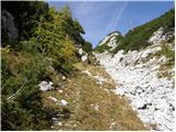 34
34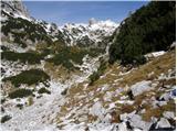 35
35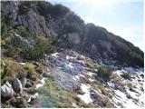 36
36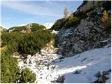 37
37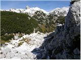 38
38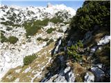 39
39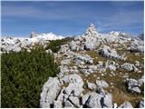 40
40
Discussion about the trip Planina Blato - Bela glava
To post a comment you must log in:
If you do not yet have a username, you must first
register.