Starting point: Planina Blato (1147 m)
| Latitude/Longitude: | 46,31120°N 13,85010°E |
| |
Walking time: 2 h 45 min
Difficulty: easy unmarked way
Elevation gain: 940 m
Elevation difference along the route: 980 m
Map: Triglav 1:25.000
Recommended equipment (summer):
Recommended equipment (winter): ice axe, crampons
Views: 56.899
 | 7 people like this post |
Access to starting point:
From the Ljubljana-Jesenice motorway, take the Lesce exit and follow the road towards Bled and further towards Bohinjska Bistrica. Continue driving towards Lake Bohinj (Ribčev laz), where you reach a junction; continue right towards Stara Fužina. In Stara Fužina, at the junction by the chapel, turn sharply left onto the ascending road towards Planina Blato, Planina Vogar and Voje Valley. The road then leads to the toll and parking fee point; follow it further to the next junction, where you continue left (right to Voje). Follow the road to the next junction (after quite some driving), where you turn sharply right towards Planina Blato (straight to Planina Vogar). Follow this road to the parking lot above Planina Blato.
Route description:
From the marked parking lot in front of Planina Blato, return slightly back and head onto a wide and initially steep cart track, alongside which there are signs for Planina pri Jezeru. After about ten minutes of ascent, arrive at a marked junction, from where continue slightly right towards Planina v Lazu (left to Koča na Planini pri Jezeru).
The path continues through the forest to a junction a few minutes away, where a steep path branches left to Planina pri Jezeru, ascending gently.
Here the path to Planina v Lazu turns right and gradually becomes steeper again, ascending transversely through the forest for some time, higher up entering the forested valley Pri deklici. The path continues northwest, still ascending through spruce forest. Higher up, where the forest flattens, reach an unmarked junction, where an unmarked shortcut branches right to Ogradi and Planina Krstenica; continue on the gentle path to a marked junction near Planina v Lazu.
Continue sharply right towards Planina Krstenica (straight down Planina v Lazu, five minutes) and follow the fairly gentle path for another about ten minutes, then from an unmarked junction with a cairn, go left onto the unmarked path leading to Ogradi.
The clearly visible but unmarked path ascends steeply further and brings you in a few minutes to the ruins of the abandoned pasture on the southern slopes of Ogradi. Here the path turns left, and the steepness gradually eases. Continue ascending on an occasionally less visible trail that climbs the grassy slope of the mountain. The increasingly scenic path then ascends somewhat more steeply again and brings you to the summit in a few more minutes of walking.
Starting point - Pri deklici 1:00, Pri deklici - junction before Planina v Lazu 0:35, junction before Planina v Lazu - turnoff to Ogradi 0:10, Turnoff to Ogradi - Ogradi 1:15.

Along the route: Pri deklici (1463m), Razpotje pred Planino v Lazu (1602m), Odcep za Ograde (1618m)
Photos:
 1
1 2
2 3
3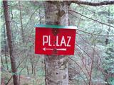 4
4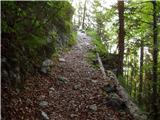 5
5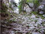 6
6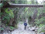 7
7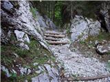 8
8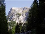 9
9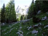 10
10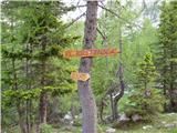 11
11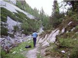 12
12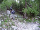 13
13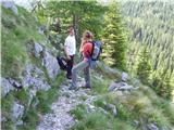 14
14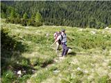 15
15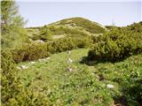 16
16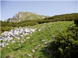 17
17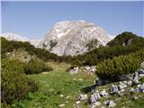 18
18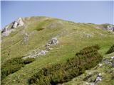 19
19 20
20 21
21 22
22 23
23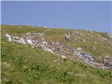 24
24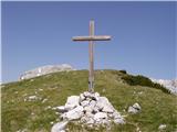 25
25 26
26
Discussion about the trip Planina Blato - Ogradi
Show older messages
|
| ljubica23. 08. 2006 |
The junction from the path to Krstenica is not hard to find-signs. On the summit meadows of Ogradi, a floral paradise! LpLj
|
|
|
|
| Gost26. 08. 2006 |
The stamp gets lost, fades. The beauties of the Ogradi remain forever within us.
|
|
|
|
| Gost29. 08. 2006 |
But not going to the mountains just for a stamp?! It's so beautiful at Ogradi that one would go again and again... I don't know when it's more beautiful: when everything blooms or in autumn when the larches are yellow??? Best regards MiR
|
|
|
|
| Gost25. 12. 2006 |
Wonderful pristine mountain nature, polluted by a symbol of religious obsession. WHY? WHAT FOR? Let's leave the mountains as they were before ideologically and religiously burdened people started visiting them, as "God" created them!
Lover of pure nature - bogdan
|
|
|
|
| Gost25. 12. 2006 |
"Religiously burdened people"? Like e.g. Aljaž (Dovški priest)
|
|
|
|
| Gost26. 12. 2006 |
I don't understand why the cross bothers you. The huts are also made by human hands. marija
|
|
|
|
| Gost26. 12. 2006 |
I agree with Mr. Bogdan..... The mountains should remain part of nature, what they are!!! I see no reason to put something up there that benefits no one... The huts are shelters (at least that was their original purpose) for mountain lovers. As for Mr. Aljaž, hats off. He was a great mountain lover ("Oj Triglav moj dom") and nationally aware, and the purpose of the monument on Triglav was to mark, if we can call it that, Slovenian land....  Nataša Nataša
|
|
|
|
| Gost26. 12. 2006 |
Better a cross on the mountain than huts full of noisy and drunk "hikers" who have made themselves so at home in some huts that they think everything is theirs.. the huts and the nature around them.. they pollute them with their rubbish, beer cans......
|
|
|
|
| Gost26. 12. 2006 |
The cross reminds me of God's love. God loves me even on the top of the mountain and knows that He loves you too. Just look how beautiful nature is. That is His love for you. marija
|
|
|
|
| Gost28. 12. 2006 |
Mrs. Marija. God loves us even without a cross on top of the mountain.
Janez
|
|
|
|
| Gost29. 12. 2006 |
Mr. Janez. Indeed God loves me whether the cross is erected or not. True. But the cross calls me to LOVE, because I so easily forget that I too must love Him - GOD. Thank you. Marija.
|
|
|
|
| Gost21. 08. 2007 |
Does anyone perhaps know the unmarked path to Ogradi that branches left just before you exit Planina Blato towards Krstenica? What is that path like? Thanks! Karl
|
|
|
|
| Gost22. 08. 2007 |
From Planina Blato you go to Planina v Lazu and before that pasture turn right towards Krstenica. Quite soon (I don't know how long) you notice an unmarked branch to the left (hope there's still a cairn there) and once you find that path, just follow it to the top of Ogradi. Nice little path, not exposed, maybe a bit at the start as it winds through rocky terrain, soon you reach grass and scree. Beautiful in autumn when larches turn golden.
Perhaps there is another variant, but I don't know it.
|
|
|
|
| Gost22. 08. 2007 |
You can also go in the reverse direction: from Planina Blato to Planina Krstenica and from there towards Planina v Lazu - before reaching Planina v Lazu, find the unmarked path to the right. From my experience, it's easier to find it if going from Planina v Lazu towards Krstenica.
|
|
|
|
| aleš4328. 10. 2009 |
On Saturday 31.10. I'll be at 7:00 at the starting point at Planina Blato. Anyone can join me. I'm not an athlete, nor a snail, so... I'd return via the lake by the hut at Planina and back to Blato! So 6-7 hour tour! I'm not an athlete, nor a snail, so... I'd return via the lake by the hut at Planina and back to Blato! So 6-7 hour tour!
|
|
|
|
| aleš4328. 10. 2009 |
correcting the date; 30.10. Saturday
|
|
|
|
| lučo28. 10. 2009 |
30 October is Friday, 31 October is Saturday?
|
|
|
|
| aleš4329. 10. 2009 |
Saturday is marked red on the calendar, I thought it was Sunday because it's Reformation holiday. So logically I mixed up Friday's date with Saturday's. Lapsus. Saturday 31.10. is correct!
|
|
|
|
| Alenka Veber13. 09. 2010 |
With the help of your description, I successfully summited the peak on 12. 9. 2010. I would only add this to the route description. The sentence: "After just a few steps we are back at the junction." - is not correct. I think there are more than 100 meters, so we cannot say after just a few steps.
|
|
|
|
| caplja31. 10. 2010 |
On November 30, we tried
to climb to Ogradi via Planina Krstenica, Planina Jezerc, but at the foot of Ogradi there was too much snow drift and the snow was too deep, so we had to give up.
Best regards.
|
|
|
|
| steleu9. 06. 2011 |
Does anyone know if it's possible to go directly from Lazoviški preval to Ogradi, because I want to combine Ogradi with a visit to Debeleg vrh?
|
|
|
|
| Janez Seliškar9. 06. 2011 |
You can reach it with easier scrambling and searching for passages along the ridge.
|
|
|
|
| steleu9. 06. 2011 |
Then there's nothing serious...
Thanks for the answer.
|
|
|
|
| šodrovec10. 06. 2011 |
A bit exposed in one or two places, but if you reach Debeli vrh without problems, Ogradi shouldn't pose any special obstacle either.
|
|
|
|
| plejade4511. 07. 2011 |
Wonderful trail and very good and clear description. I really recommend this trip, especially if you're working on optimal fitness and looking for a moderately demanding excursion.
|
|
|
|
| damijanp12. 07. 2011 |
I join the recommendations - wonderful path, peace, flowers, ...
Some photos are at the link:
Ogradi
|
|
|
|
| ljubitelj gora3. 11. 2011 |
To Ogradi you can ascend from both sides, both paths are trodden but unmarked, the upper path is easier, light, while the one from the direction of pl.v Lazu (that's the path to Debeli vrh and Ogradi) requires climbing on all fours, and the ridge is also exposed with brushwood.
|
|
|
|
| ruševec19. 08. 2012 |
Yesterday my friend and I climbed Ogradi from Lazovski preval via the north side. On all easier sections the path is clearly visible and it's no longer real pathless terrain. It starts with a path along the ridge through dwarf pines, leading to rocks. Follows a short climbing section where hands are necessary. Many such sections on marked paths would be well secured. Here you have to fiddle a bit finding holds. After climbing out of the rocky chimney follows what for me is the hardest part. Steep exposed grassy slope strewn with "scree". After 10-15 minutes of climbing we're already on the summit ridge, which again isn't too hard. Since my friend and I didn't know there's an easier path to Planina Laz, we descended the same way. On descent caution is really not superfluous! True, no stamp at the top and no logbook, but real mountain peace is found here. Crowds of hikers rush to Triglav Lakes and Triglav, these areas are paradise for those seeking peace.
|
|
|
|
| darh27. 10. 2012 |
Last Saturday we ascended to Ogradi via the described path, and returned to the starting point via planina Krstenica. We had no orientation problems at all. To our surprise we were not the only ones who set this goal. More about our impressions and photos from the path can be found here.
|
|
|
|
| jprim29. 10. 2012 |
We probably met that day.
|
|
|
|
| Frenkii29. 10. 2012 |
Opposite the Ogradi stand the haystacks: Prevalski, Jezerski and Krsteniški.
Does anyone know the crossing to Prevalski stog directly from Jezerski preval? I know you can get there via the northern slope with a bit of scrambling. What about the southeast one? It looks doable, but no path, marker, crossing is visible ....
|
|
|
|
| felix30. 10. 2012 |
Between Prevalski and Jezerski S. there are also Adam and Eva. We too were looking for the mentioned crossing last week, Somewhere between Eva and Prevalski Stog it would be possible to cross, we tried one section, but since we didn't know what the exit would be like and didn't have a rope with us, we turned back.
|
|
|
|
| Frenkii30. 10. 2012 |
Thanks for the reply.
I'll try in spring. Somewhere below EVA it might work.
|
|
|
|
| iztok.maltar30. 10. 2012 |
I took that variant in the opposite direction this summer, branch off a bit more than halfway up from planina Jezerce to Jezerski preval. Above you reach the S slope of Adama, find the chamois path and a bit further climb via steep meadow almost to the top of Adama. Otherwise they climb directly from the pass to Eva, up to grade II.
|
|
|
|
| Dr.ejči30. 10. 2012 |
Frenkii, I described that direct one to you on ZS.
|
|
|
|
| Bojan_A30. 10. 2012 |
From Jezerski preval it's not even remotely II, but at best barely I going up with exaggeration.
|
|
|
|
| Bojan_A30. 10. 2012 |
Oops, misread it, 
|
|
|
|
| iztok.maltar30. 10. 2012 |
Hey guys, I also recommend the description of the direct route, there's never too much information. This year downhill I didn't risk it, I went nicely around. Next time in the opposite direction I'll go directly up.
|
|
|
|
| fravnik8. 11. 2012 |
Thanks everyone for the information.
iztok79: unfortunately the link doesn't work for security reasons(?)
Dr.ejči: Help! what is ZS (private message?)
ajda: thanks!
|
|
|
|
| Dr.ejči8. 11. 2012 |
Yes, ZS is private message...you have one
|
|
|
|
| katja871. 07. 2013 |
On Sunday, 30.6.2013, we concluded our tour with an ascent to Ogradi.
We did a circular tour: Planina Blato - Planina Krstenica - Jezerski Stog - Prevalski Stog - Mišeljski preval - Debeli vrh - Lazovški preval - Ogradi - Planina Blato.
The tour lasted 14 hours and was quite demanding, mainly due to repeated ascents and descents. However, in the end everything was rewarded with fantastic views from the summits
Pictures from the hike can be viewed on the website of the Matica Murska Sobota Mountaineering Association: http://www.mojalbum.com/pdmaticams/20130630-od-jezerskega-stoga-do-ogradov/informativna-tabla-na-parkiriscu/20897646
|
|
|
|
| Pohodnica562. 08. 2013 |
Ogradi have tempted me for a long time. But I'd rather go in the opposite direction up over Lazovski preval on the unmarked path and then down the other side towards Krstenica. I haven't found a description of this path anywhere. Surely someone has walked it and could help me. Thanks and nice mountain greetings.
|
|
|
|
| grega_p23. 09. 2014 |
Pohodnica56 - it's been more than a year waiting for an answer, but anyway... maybe it still helps. The description of the path you're asking about is in the comments above (post by Ruševec), the descent to Krstenica is in the upper description/ascent of the path.
If you're interested in the descent to Krstenica on the north side, then you return along the same path to Lazovški preval and turn right (towards the east or towards Stogi) and descend past the bushes by the wall where ravens like to nest and turn right at the junction of the path (left Mišeljski preval). Follow this path past Jezerce to Krstenica. Descent I'd say about 1.15h.
Today up there the young wind was blowing. Good thing I don't take up much space, otherwise it would have blown me off the ridge.
One more thing: since I started in the dark, I avoided paying the toll, on the way back I waved friendly and they let me through. It worked. Otherwise I'd gladly throw a couple of euros into the voluntary hat if it were there...
|
|
|
|
| SuzanaM25. 09. 2014 |
About a year ago I was at Ogradi from Planina Krstenica over Lazovski preval, I returned past Planina v Lazu to Planina Blato.
From Planina Jezerce to Lazovski preval after initial wandering I found a nice passage marked by cairns. Instead of straight under the walls, we climb left up some kind of gully. From Lazovski preval to the top of Ogradi, hands are needed in a few places.
Path description from 7.11.2013 at the link below:
http://www.hribi.net/trenutnerazmere.asp?slo=1&gorovjeid=1&id=694&stran=3
|
|
|
|
| velkavrh25. 09. 2014 |
PD Škofja Loka has a planned trip to Ograde on October 11, 2014. It goes from Planina Blato to Planina Krstenica and Planina Jezerca and to Lazovski preval to the top of Ogradi. Descent is over Planina v Lazu.
|
|
|
|
| grega_p26. 09. 2014 |
SuzanaM - I also went through that gully, but except at the beginning I didn't see any cairns, so later I preferred to turn under the walls to the path. Orientation is definitely not difficult, as we have Lazovski preval in front of us, just probably best to avoid the bushes on the left...
|
|
|
|
| spet_jaz16. 11. 2017 |
A week ago in winter conditions towards the summit, which was unfortunately unreachable for us due to conditions. Description and some photos at the link.
|
|
|
|
| cotro411. 08. 2018 |
alone all day on the trail, beautiful as always
|
|
|
|
| BorStenar20. 11. 2022 12:47:16 |
About a month ago I was at Ogradi. The view was exceptional, I had the camera with me, but at 0%...
|
|
|
|
| G3420. 11. 2022 17:51:54 |
I was on this mountain. The view was really exceptional, there was no snow up there at all. Triglav was seen the best. It was a really characteristic view on Triglav.
|
|
|
|
| tango21. 11. 2022 09:06:01 |
G34, on which date was there no snow?
|
|
|
|
| BorStenar21. 11. 2022 14:12:28 |
Went to Ogradi on November 6, 2022. There was no snow at the summit.
|
|
|
|
| Lazo15. 07. 2023 19:53:10 |
Hello!
Another successful path that showed wonderful views. Here is a recording if you want to watch it and perhaps decide more easily if you are properly prepared for such an ascent.
I was also lucky because all the alpine flowers were blooming!
Safe steps.
https://youtu.be/m0r03kNK8V0
|
|
|
|
| gorska.zvezda24. 07. 2023 15:53:04 |
Hey Lazo,
Thanks for the video that vividly shows the path to Ogradi, which is otherwise described as unmarked. With your video I can finally head to this wonderful mountain.
Stay well!
|
|
|
To post a comment you must log in:
If you do not yet have a username, you must first
register.