Planina Blato - Planina Lopučnica (via Štapce)
Starting point: Planina Blato (1147 m)
| Latitude/Longitude: | 46,31120°N 13,85010°E |
| |
Route name: via Štapce
Walking time: 3 h 45 min
Difficulty: partly demanding marked way
Elevation gain: 411 m
Elevation difference along the route: 850 m
Map: TNP 1:50.000
Recommended equipment (summer): helmet
Recommended equipment (winter): helmet, ice axe, crampons
Views: 2.161
 | 1 person like this post |
Access to starting point:
From the Ljubljana - Jesenice motorway, take the Lesce exit and follow the road towards Bled and further towards Bohinjska Bistrica. Continue driving towards Lake Bohinj (Ribčev laz), where you reach a junction and continue right towards Stara Fužina. In Stara Fužina, at the junction by the chapel, turn sharply left onto the ascending road towards Planina Blato, Planina Vogar and Voje Valley. The road then leads to the toll and parking collection point, but follow it further to the next junction, where you continue left (right Voje). Follow the road to the next junction (after driving for quite some time), where you turn sharply right towards Planina Blato (straight Planina Vogar). Follow this road to the parking lot in front of Planina Blato.
Route description:
From the marked parking lot, return slightly back along the road, then head onto the ascending cart track towards Planina pri Jezeru, Planina v Lazu and Planina Dedno polje. The path on the cart track initially climbs quite steeply and after about ten minutes brings us to a marked junction, where we continue on the left, upper cart track (straight Planina v Lazu and steep path to Planina pri Jezeru).
After less than five minutes of further ascent, in a right bend, a path from Planina Vogar joins from the left, but we continue right towards Planina pri Jezeru. Further on, we ascend a slightly less steep cart track, which flattens completely for a short time, then climbs more steeply and leads us through an artificial "choke". After the "choke", the cart track flattens again, and after two benches, the aforementioned steep path joins from the right. After the junction, the path turns left and brings us to a pasture fence, behind which we enter a small valley where cold air usually lingers. The path ahead gradually becomes steeper again, then, when it flattens, turns right. A little further, a path joins from the left leading over or past Planina Vodični vrh.
From the mentioned junction onwards, the forest begins to thin, and when we finally step out of the forest, we are already at Planina pri Jezeru, where only a few dozen steps of easy walking separate us from the nearby mountain hut.
From the hut, continue left downhill (slightly right Planina v Lazu and Vodnikov dom na Velem polju) and descend to the shepherds' huts, where there is the next marked junction.
From the junction, continue straight towards Planina Dedno polje (left uphill Planina Viševnik) and continue the path along the cart track, which from the pasture begins to climb more steeply. Higher up, another path branches left towards Planina Viševnik, namely the path past Krištofojce, but we follow the wide cart track all the way to Planina Dedno polje, from which a nice view opens up to the surrounding mountains.
Bypass the shepherds' huts and cheese dairy on the left side and continue straight towards Koča pri Triglavskih jezerih (right valley Za Kopico). From the pasture onwards, we begin a moderate ascent, and almost imperceptibly from the left, a path from the nearby hunting hut joins. A little further, the path leads past another branch towards Planina Viševnik (path along Griva (1758 m)), and in the next few minutes we reach the upper edge of the vast Planina Ovčarija, from where a nice view opens up to the Bohinj-Tolmin mountains, sometimes called Lower Bohinj Mountains. From here follows a short descent, then from the left a path from Planina Vogar joins, which leads over Planina Viševnik, and a few steps further the path splits into two parts.
From the fork, follow the signs for the path over Štapce (straight path over Prodov), both leading towards Koča pri Triglavskih jezerih, the right one, which we will follow, also towards Mala Tičarica and Zelnarice. We soon leave Planina Ovčarija and the path ascends moderately to steeply through increasingly sparse forest, which higher up is replaced by dwarf pine. After a half-hour ascent, the path flattens and brings us to Štapce, where we continue on the left path towards Triglav Lakes (right Mala Tičarica...). When we step to the edge, a nice view opens up over part of the Triglav Lakes Valley and the mountains surrounding that valley, extending all the way to Krn.
From Štapce first follows a steep, well-secured descent over a rocky step, then the path transitions to scree, down which we descend to the belt of dwarf pine. Follows a little more descent and from the left the path over Prodov and the path from Koča pri Savici (path over Komarčo) join us, but we continue right and further walk along Dvojno jezero. When we leave the lake, only a few dozen steps of easy walking separate us from Koča pri Triglavskih jezerih.
After we rest and enjoy the views, we continue the path towards Dom na Komni. The path further leads along the right (western) side of the lake and ascends transversely. A little further, near the hunting hut, which is otherwise not visible from the path, the path curves semi-circularly right and gradually begins to descend. Somewhere in the middle of the descent towards Planina Lopučnica, on a small flat area where the marked path we continue on turns left, an unmarked path branches right leading towards the Zgornje Komne plateau and Gladkem and Debelem Laš (the mentioned path higher up gets lost in the karst world).
When lower down we reach the marked junction, we are already at Planina Lopučnica.
Starting point - Planina pri Jezeru 1:00, Planina pri Jezeru - Planina Dedno polje 0:30, Planina Dedno polje - Planina Ovčarija 0:45, Planina Ovčarija - Štapce 0:35, Štapce - Dvojno jezero 0:20, Dvojno jezero - Koča pri Triglavskih jezerih 0:05, Koča pri Triglavskih jezerih - Planina Lopučnica 0:30.

Photos:
 1
1 2
2 3
3 4
4 5
5 6
6 7
7 8
8 9
9 10
10 11
11 12
12 13
13 14
14 15
15 16
16 17
17 18
18 19
19 20
20 21
21 22
22 23
23 24
24 25
25 26
26 27
27 28
28 29
29 30
30 31
31 32
32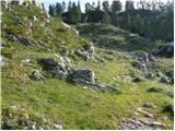 33
33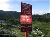 34
34 35
35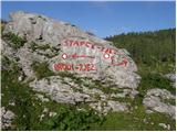 36
36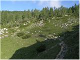 37
37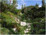 38
38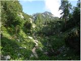 39
39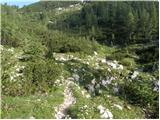 40
40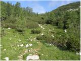 41
41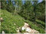 42
42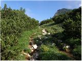 43
43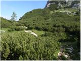 44
44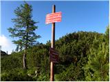 45
45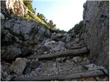 46
46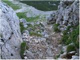 47
47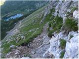 48
48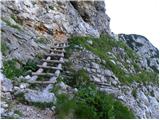 49
49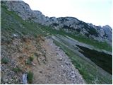 50
50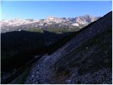 51
51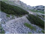 52
52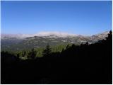 53
53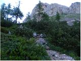 54
54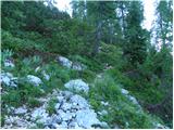 55
55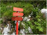 56
56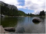 57
57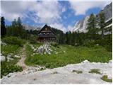 58
58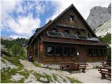 59
59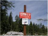 60
60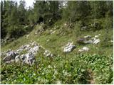 61
61 62
62 63
63 64
64 65
65 66
66 67
67
Discussion about the trip Planina Blato - Planina Lopučnica (via Štapce)
To post a comment you must log in:
If you do not yet have a username, you must first
register.