Starting point: Planina Blato (1147 m)
| Latitude/Longitude: | 46,31120°N 13,85010°E |
| |
Walking time: 2 h 30 min
Difficulty: easy marked way
Elevation gain: 614 m
Elevation difference along the route: 645 m
Map: Triglav 1:25.000
Recommended equipment (summer):
Recommended equipment (winter): ice axe, crampons
Views: 37.994
 | 3 people like this post |
Access to starting point:
From the Ljubljana - Jesenice motorway, take the Lesce exit and follow the road towards Bled and further towards Bohinjska Bistrica. Continue driving towards Lake Bohinj (Ribčev laz), where you reach a junction and continue right towards Stara Fužina. In Stara Fužina, at the junction by the chapel, turn sharply left onto the ascending road towards Planina Blato, Planina Vogar and Voje valley. The road then takes you to the toll and parking fee collection point; follow it further to the next junction, where you continue left (right Voje). Then follow the road to the next junction (it takes quite some time), where you turn sharply right towards Planina Blato (straight Planina Vogar). Follow this road to the parking lot above Planina Blato.
Route description:
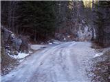
From the marked parking lot in front of Planina Blato, return a little back and head onto a wide and initially also steep cart track, alongside which are signs for Planina pri Jezeru. After about ten minutes of ascent, you arrive at a marked junction, from where you continue left towards Planina pri Jezeru (slightly right Planina v Lazu and also the steep path towards Planina pri Jezeru).
Continue on the less steep cart track, which continues to lead through the forest; a little further on, a marked path joins from the left leading past Kosijev dom on Vogar, but you continue right and keep walking on the cart track. Higher up, the path leads through a narrow passage, then crosses quite steep slopes where there is a high risk of slipping on ice and snow, otherwise the path is not demanding. At the end of the steep slope, the aforementioned steep path joins unobtrusively from the right, and the cart track here turns left and enters the rather cool Pungrat valley, where you ascend through mostly spruce forest. When the path levels out higher up, another path joins from the left leading past Planina Vodični vrh; you keep slightly to the right direction and continue walking on the cart track, alongside which the forest begins to thin. A few more minutes of easy walking follow, and you step onto the pastures of Planina pri Jezeru, where the Koča na Planini pri Jezeru hut stands on a small hillock.
At the hut, a path branches right towards Planina v Lazu; you continue left from the hut and descend to a marked junction, where there are also a few shepherds' huts.
Choose the left path, alongside which are signs for Planina Viševnik, Pršivec and Črno jezero (slightly right Planina Dedno polje and Koča pri Triglavskih jezerih and Planina Viševnik via Krištofojca); you first pass a few huts, then ascend transversely across the southwestern part of the pasture. Higher up, the path enters the forest, where it ascends steeply for a while, then levels out somewhat, but ascends through the forest to the eastern edge of Planina Viševnik. Here, the path from Krištofojca joins from the right; with some views of the surroundings, you ascend to Bregarjevo zavetišče on Planina Viševnik.
From Planina Viševnik, where several paths meet, head slightly left southwest towards Pršivec (straight Črno jezero, slightly right Planina Ovčarija, sharply left Planina Vogar) and ascend transversely to the southwestern part of the pasture, where the path turns even more left and heads south. A bit of transverse ascent through the forest follows, then the path levels out and even descends slightly to Majska jama (shaft explored to a depth of 592 m), from where you begin ascending again, this time along the northern slopes of Pršivec. Another approximately 15 minutes of ascent through increasingly sparse, mostly larch forest follows, and you reach the summit of Pršivec, from which a beautiful view opens up to Bohinj and the surrounding mountains.
Izhodišče - Planina pri Jezeru 1:00, Planina pri Jezeru - Planina Viševnik 0:30, Planina Viševnik - Majska jama 0:45, Majska jama - Pršivec 0:15.

Photos:
 1
1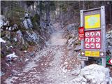 2
2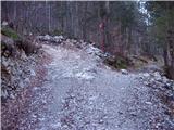 3
3 4
4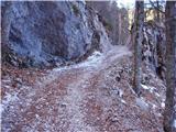 5
5 6
6 7
7 8
8 9
9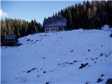 10
10 11
11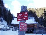 12
12 13
13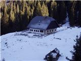 14
14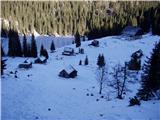 15
15 16
16 17
17 18
18 19
19 20
20 21
21 22
22 23
23 24
24 25
25 26
26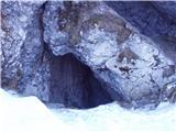 27
27 28
28 29
29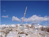 30
30 31
31
Discussion about the trip Planina Blato - Pršivec
|
| akvarij7. 09. 2009 |
Yesterday (6/9/2009) we went on the described hike; two families with children from 6 to 14 years old and we had a great time. The view from Pršivec is one of the most beautiful views we have experienced so far.
For hikers with children, the most "useful" thing on this path is that there are many opportunities for pleasant stops (planina pri Jezeru, planina Viševnik, caves, currently you can also find raspberries, blueberries, even strawberries)...
|
|
|
|
| peter223. 05. 2010 |
From the end of the road coming from Vogar the path to Pršivec is dry and without issues.
Completely different if returning via planina Viševnik. From Pršivec to the planina there's quite a bit of path still in snow, which sinks to the ground in places. Planina Viševnik is dry.
Some pictures: http://www.petersfoto.si
|
|
|
To post a comment you must log in:
If you do not yet have a username, you must first
register.