Planina Blato - Škednjovec (on east ridge)
Starting point: Planina Blato (1147 m)
| Latitude/Longitude: | 46,31120°N 13,85010°E |
| |
Route name: on east ridge
Walking time: 5 h
Difficulty: very difficult pathless terrain
Elevation gain: 1162 m
Elevation difference along the route: 1162 m
Map: Triglav 1: 25000
Recommended equipment (summer): helmet
Recommended equipment (winter): helmet, ice axe, crampons
Views: 7.120
 | 7 people like this post |
Access to starting point:
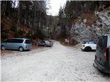
From the Ljubljana–Jesenice motorway, we take the Lesce exit and continue through Bled and Bohinjska Bistrica towards Bohinj. At Lake Bohinj, we turn right over the bridge, where we drive past the old church of St. John the Baptist in Stara Fužina. In the centre of the village, between the inn and the cultural centre, where there is a replica of the Triglav Tower, at the crossroads we turn sharply left onto the road leading to the mountain pastures Vogar and Blato. At the end of the village, there is a larger parking lot by the road; in summer or during the season, a toll or parking fee is charged for cars. We continue on the narrow asphalt road, which first rises slightly, then flattens a little through the pastures above the village. When the forest starts, we come to a crossroads, where there is a marked turn-off to the right for the Voje Valley, but we continue left to Vogar and Blato. After approx. 6–7 km of moderately ascending and winding road, we arrive at a crossroads, where we turn right towards Planina Blato (straight ahead to Planina Vogar) and follow it all the way to the parking lot and barrier before Planina Blato. If it is full (often at weekends and in nice summer weather), it is possible to park at several places along the road.
Route description:
From the parking lot, we continue past the barrier on a macadam road which in a few steps brings us to a right-hand bend, where ahead of us we notice the lower part of Planina Blato, and on the right – right above the road – we also notice the start of the hunting trail and signpost for Planina Krstenica, where at the beginning, for a safer step above the road, a short fixed cable is installed.
We then follow a comfortable level path through the forest, which gently turns right, all the way to the point where it is crossed by a wide cart track from the mountain pasture. We then cross the cart track and follow the ascending path, which soon turns right again and runs through the forest parallel above a relatively steep cart track. After approximately 15 minutes of walking, at the end of a smaller clearing, the path turns further left and climbs in a few hairpins over a short steep ascent; further to Planina Krstenica, there are still a few gentler and a few steep sections of the path. Before leaving the forest section of the path, we notice a small hunting hut on the left side, from there we soon reach the lower pasture, where the cart track rejoins us from the right. There follow another good 5 minutes of walking and we arrive at the very panoramic and sunny Planina Krstenica, where nowadays there are about ten more or less well-kept huts (bajti), somewhere in the middle, at the water trough under the largest hut, there is also a wooden signpost.
From the mountain pasture, between the huts, we keep more to the left, then several smaller paths above the huts on the western side of the mountain pasture merge into one well-visible path, which gently brings us below the slopes of Krsteniški and Jezerski Stog to the small abandoned Planina Jezerce. There, behind the water trough, we head right upwards, where a well-visible path leads towards Jezerski Preval, above which rise Adam and Eva. We follow this path for only a few dozen metres, then immediately turn left onto a less visible little path leading into the upper small valley. The little path first rises slightly, then takes us roughly along the middle of the right slope almost horizontally below scree slopes and steep cliffs. On the opposite side of the little valley, the Ogradi rise steeply. We walk almost to the head of the valley, where the path turns right and begins to ascend below the grassy slopes of Prevalski Stog towards Mišeljski Preval. At the pass, we encounter blazes and the marked path Lazovški Preval – Velo Polje.
From the pass, down which a steep path also descends from Prevalski Stog, we head to the opposite slope on pathless terrain leading between low dwarf pines and grasses, partly between smooth rocky slabs, towards Škednjovec and Mišeljska Dolina. When the slope flattens a little, we also notice some cairns showing easier passages through the varied terrain of small caves, limestone pavements and gullies. Since we can see Škednjovec and its eastern ridge constantly ahead of us, orientation in fine weather causes no major problems. We can climb directly up the first relatively domed forepeak, but due to its considerable steepness, it is more advisable to bypass it on the right; when seeking the best passages, we also need to watch out for numerous deep caves and pits. We then arrive at a comfortable grassy saddle, where a view opens onto the mighty second forepeak, which we tackle on a short and easy rocky step likewise from the right (on the southern sides of the ridge, the walls are more overhanging and precipitous). On the followable but varied terrain upwards, we reach the most critical point of this ascent, namely crossing some ten metres of smooth and steep slab, which when wet or frozen is very dangerous for falling or slipping. Further on, we reach a wider but very steep rocky slope, which near the wall on the left is quite gravelly, so it is safer to head a bit further right into the smaller/narrower but from afar visible rocky gully leading all the way to the top of the ridge saddle above the second forepeak. In the gully, we climb a little to the right, a little to the left, in the upper part also in the middle, depending on where we get a better hold, but the scrambling does not exceed grade I. When we exit this gully (about 60 m long), we step again onto a narrower grassy saddle, from here onwards only up the ridge, which narrows more in places and less elsewhere; there follows a third rest on the ridge and then over the last forepeak, which is relatively the widest, and you will also be surprised by the relatively comfortable summit.
For descent, the western ridge and drop to the saddle between Škednjovec and Vrh Hribaric is recommended, which is shorter but due to the friability and exposure of the ridge likewise very demanding and by no means suitable for the vertiginous or less experienced. From the pass, you can return most quickly back towards Mišeljski or Lazovški Preval via scree and the valley below Škednjovec.
Approximate walking time: Planina Blato – Planina Krstenica: 1 hour, Planina Krstenica – Planina Jezerce – Mišeljski Preval: 1.5 hours, Mišeljski Preval – Škednjovec (summit): 1.5 hours. Descent via the western ridge to the pass or saddle (between Škednjovec and Vrh Hribaric): 0.5 hours.

Photos:
 1
1 2
2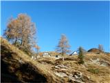 3
3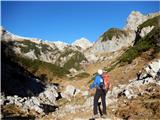 4
4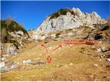 5
5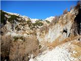 6
6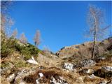 7
7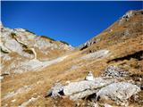 8
8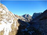 9
9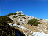 10
10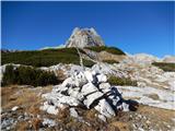 11
11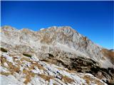 12
12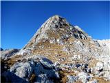 13
13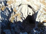 14
14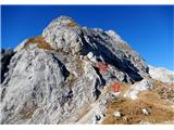 15
15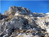 16
16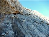 17
17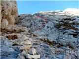 18
18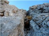 19
19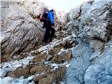 20
20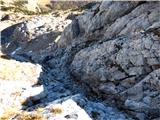 21
21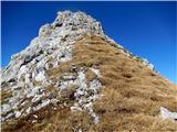 22
22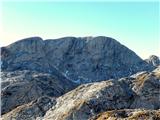 23
23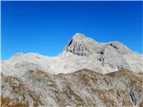 24
24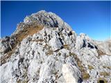 25
25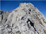 26
26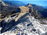 27
27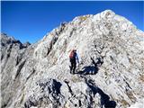 28
28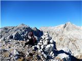 29
29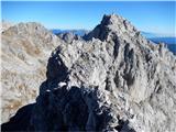 30
30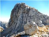 31
31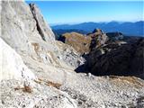 32
32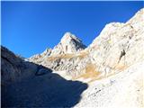 33
33
Discussion about the trip Planina Blato - Škednjovec (on east ridge)
|
| ločanka18. 11. 2015 |
I really liked the scenery at that mentioned saddle between Škednjovec and Vrh Hribaric! Nice view here of the north face of Škednjovec, to me the best view of it!
|
|
|
|
| Wine9. 10. 2017 |
Did this route yesterday, 8.10.
It's a very nice traverse... recommend from east to west, so that the nasty scree under the summit is crossed downhill. Larches are golden! 
|
|
|
|
| pikica19. 10. 2017 |
Everything painted up there according to the pictures. Little bushes left and right, good thing he didn't draw a traffic light.
|
|
|
|
| turbo9. 10. 2017 |
@pikica1
... maybe soon in the mountains something similar to the valley  looking at the tablet in hand two steps left, one right, tablet in pocket and pull over the edge, then again with tablet a bit here and there looking at the tablet in hand two steps left, one right, tablet in pocket and pull over the edge, then again with tablet a bit here and there  God help God help 
|
|
|
|
| kristi29. 10. 2017 |
maybe there's something wrong with you?
|
|
|
|
| sAleska23. 06. 2019 |
Is there on the path (under the summit) still any snow patch? Thanks for info.
|
|
|
To post a comment you must log in:
If you do not yet have a username, you must first
register.