Planina - Grmada (Planinska gora)
Starting point: Planina (520 m)
| Latitude/Longitude: | 45,82640°N 14,23580°E |
| |
Walking time: 1 h
Difficulty: easy unmarked way
Elevation gain: 353 m
Elevation difference along the route: 353 m
Map: Snežnik 1:50.000
Recommended equipment (summer):
Recommended equipment (winter):
Views: 27.771
 | 1 person like this post |
Access to starting point:
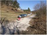
From Ljubljana, we drive on the highway towards Koper and take the Unec exit. At the intersection, we continue right in the direction of Planina, where at the intersection we turn sharply left towards Postojna (up to here also possible on the old road). Further, we drive through Planina and at the spot where we notice signs for Strmca and Studeno, we turn right. The road soon brings us to the next intersection, where it says left Postojna, straight Strmca and Studeno, and right nothing. Here we turn right (towards the quarry) and drive only 30 m to the spot where a worse road branches off to the left, alongside which we park.
From Postojna on the old road we drive towards Ljubljana. Soon after the village Mačkovec, in a sharp right bend, a road branches off to the left towards the village Strmca. This road then soon brings us to the next intersection, where we continue straight towards the quarry. We do not follow this road to the quarry because already after 30 m we leave it by turning left onto a worse road alongside which we park.
Route description:
From the parking lot, we continue on the worse road ahead, but only to a smaller water supply building. Here a cart track branches off to the right, which already after a few meters steeply ascends. The cart track, which runs through the forest, is at the beginning really very steep but the steepness eases after a few minutes. There follows a moderate ascent on the cart track, which eventually joins another wider one. Here we continue left on the cart track, which gently ascends and after a few minutes joins the next cart track, which is already almost a worse road. Here we can along the path notice a few old military trenches. This path then quickly brings us to the church of Holy Mary.
At the church, we step on a macadam road along which we continue the ascent. After a good 10 minutes of additional walking, we will notice on the right side a cart track which leads us to extensive grassy slopes. Across the mentioned slopes we walk on a somewhat worse cart track, which directs us slightly right. After a few dozen pleasant steps, the path brings us to a viewpoint from which a wonderful view opens up on Planinsko polje.
Near the viewpoint, at the edge of the forest we notice an unmarked mountain path, which directs us sharply right and along which in 3 minutes of walking we ascend to the forest-covered peak of Grmada.

Photos:
 1
1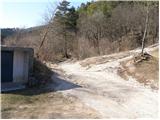 2
2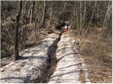 3
3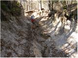 4
4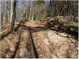 5
5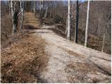 6
6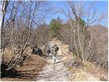 7
7 8
8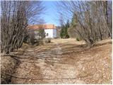 9
9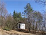 10
10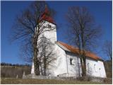 11
11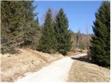 12
12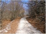 13
13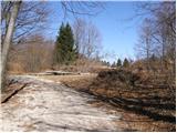 14
14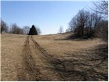 15
15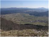 16
16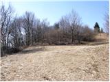 17
17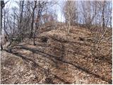 18
18 19
19
Discussion about the trip Planina - Grmada (Planinska gora)
|
| grega_p1. 02. 2010 |
Today I went up in a beautiful winter idyll and made a trail at least at the beginning. Since I don't know the path otherwise, I veered a bit from the usual direction and made a small detour, which I noticed only upon approach, so some hiker behind me won't necessarily follow my footsteps.. Take advantage of sunny snowy days!
|
|
|
|
| lipnes3. 09. 2010 |
I was yesterday. On the third attempt in less than two years I finally found the summit.  I went up the road by bike via Laz through Planina and Lohacho. Nice aerobic training. I went up the road by bike via Laz through Planina and Lohacho. Nice aerobic training.
|
|
|
|
| jesihar5. 10. 2011 |
I went up in running shoes, I don't recommend it. I modified the path a bit and went up near the mountain church and "shortened" it, so I went straight up the hill instead of the forest path. I don't recommend that either, due to the thick layer of leaves and quite steep incline. The hill is worth it for the nice view of Planinsko polje.
|
|
|
|
| Lj28. 11. 2015 |
I would like information, is Planinska gora another name for Grmada? Namely, on the Notranjski kras map, there is another peak marked nearby named Planinska gora (924 m) and I'm wondering why in this description Grmada is also named the same?
|
|
|
|
| Tadej28. 11. 2015 |
Grmada, which is described above, is located on Planinska gora. After the word Grmada, Planinska gora is written in brackets to distinguish which Grmada it is, since there are several Grmadas in Slovenia.
http://www.hribi.net/zemljevid_poti.asp?id=1221
|
|
|
|
| Lj28. 11. 2015 |
Thanks, so this my map is not correct...
|
|
|
To post a comment you must log in:
If you do not yet have a username, you must first
register.