Planina Jezerca - Kalška gora (via planina Koren)
Starting point: Planina Jezerca (1410 m)
| Latitude/Longitude: | 46,28550°N 14,53140°E |
| |
Route name: via planina Koren
Walking time: 4 h 35 min
Difficulty: partly demanding marked way
Elevation gain: 637 m
Elevation difference along the route: 940 m
Map: Kamniške in Savinjske Alpe 1:50.000
Recommended equipment (summer):
Recommended equipment (winter): ice axe, crampons
Views: 6.119
 | 1 person like this post |
Access to starting point:
A) From the Ljubljana - Jesenice highway, take the Vodice exit, then continue driving to the first traffic-light intersection in Vodice, where we continue left towards Cerklje na Gorenjskem and Brnik. When we arrive at the main roundabout in Spodnji Brnik, we continue driving towards Cerklje and the Krvavec ski centre. At the end of the settlement Cerklje na Gorenjskem, we leave the main road, which continues towards Velesovo and Visoko, and continue slightly right onto the road towards the Krvavec ski centre. Further on, we arrive at the village of Grad, where signs for the settlement Ambrož pod Krvavcem direct us right onto a steep asphalt road (straight: lower station of the monocable gondola to Krvavec and Štefanja Gora). When the steepness on the steep road eases a little, we arrive at an intersection, where we continue left towards the settlement Ambrož pod Krvavcem (straight: settlements Ravne, Apno and Šenturška Gora). A little further, the road temporarily descends a little, then ascends through occasionally quite panoramic slopes. Higher up, we arrive at Ambrož pod Krvavcem, where we bypass the church of St. Ambrož and the tourist farm Pr Ambružarju on the left side. From the tourist farm onwards, the road enters the forest and ascends through it all the way to the mountain pasture Jezerca, where there is a large arranged parking lot.
B) From the Jesenice - Ljubljana highway, take the Kranj-East exit, then continue driving towards Brnik, Komenda and Mengeš. When we arrive at the main roundabout in Spodnji Brnik, we continue driving towards Cerklje and the Krvavec ski centre. At the end of the settlement Cerklje na Gorenjskem, we leave the main road, which continues towards Velesovo and Visoko, and continue slightly right onto the road towards the Krvavec ski centre. Further on, we arrive at the village of Grad, where signs for the settlement Ambrož pod Krvavcem direct us right onto a steep asphalt road (straight: lower station of the monocable gondola to Krvavec and Štefanja Gora). When the steepness on the steep road eases a little, we arrive at an intersection, where we continue left towards the settlement Ambrož pod Krvavcem (straight: settlements Ravne, Apno and Šenturška Gora). A little further, the road temporarily descends a little, then ascends through occasionally quite panoramic slopes. Higher up, we arrive at Ambrož pod Krvavcem, where we bypass the church of St. Ambrož and the tourist farm Pr Ambružarju on the left side. From the tourist farm onwards, the road enters the forest and ascends through it all the way to the mountain pasture Jezerca, where there is a large arranged parking lot.
Route description:
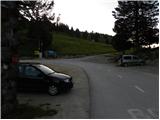
At the end of the parking lot, where the road turns left and a road branches right towards the nearby mountain pasture Jezerca, we notice red hiking signposts that direct us straight onto a marked footpath towards Kriška planina, Vrh Korena, Košutna, Kompotela and Mokrica, which climbs through the pastures of the aforementioned mountain pasture. After a short ascent, we reach a cart track, which we follow left, crossing the slopes of Kržišče (1658 m). The cart track along which we walk soon splits into two parts, and we continue straight on the lower one. Temporarily, a nice view opens towards Kranj, Škofjeloško hribovje and Storžič, then the path begins to descend gently. A few more minutes of walking follow, then we arrive at the parking lot at the lower part of Kriška planina.
From the parking lot, we continue towards planina Koren along a poorer macadam road that passes through an underpass beneath the ski slope. After the underpass, the marked path veers slightly left from the road, continuing parallel to it along a sort of spruce avenue. After a few minutes of gentle ascent, when we reach the eastern edge of Kriška planina, where there is a small watering hole for animals, we continue slightly left across the pasture fence (right: planina Osredek and Kamniški vrh), continuing the gentle ascent in roughly the same direction. The path then transitions from the mountain pasture onto somewhat steeper slopes of Krvavec, across which we ascend transversely to a viewpoint from which a nice view opens towards Kržišče (Pokovše), the ridge of Kamniški vrh, the Korošica valley, Velika planina and the nearby Košutna and Veliki Zvoh.
From the viewpoint, located a few steps to the right off the path, we begin descending more steeply towards the hunting hut above the Korošica valley. When the descent ends and the path continues without major elevation changes, we arrive at a visible but poorly marked junction, where a path branches right to the aforementioned hunting hut and further towards the Korošica valley and Kamniška Bistrica valley. At this junction, we continue slightly left and begin ascending gently through the forest. The path quickly exits the forest into bushes and dwarf pines, then gradually leads us over the pasture fence to the next unmarked junction, located right in the middle of a sharp right-hand bend.
From this hairpin bend, an unmarked path continues straight towards the Razor saddle (saddle between Krvavec and Veliki Zvoh), while we continue right on the still-marked path. A short transverse ascent follows, bringing us to the southern part of planina Koren, from where a nice view opens over the central part of the pasture and surrounding peaks. From the southern part of the pasture, a short descent leads to the nearby shepherd's hut located in the central part of planina Koren.
Here, our path continues slightly left (slightly right: planina Košutna) across meadows at the valley bottom (the path is initially poorly visible). The path then becomes steeper, bringing us after less than 30 minutes of walking to a small puddle with a poorly marked junction. We continue straight (right: Košutna) following the gentle path to the next junction, where we turn left towards Vrh Korena (straight: Kompotela). The path ahead steepens and quickly leads us through karst terrain to the point where we join the path from Veliki Zvoh towards Vrh Korena (Jež ridge). We continue right, and the path brings us in a few steps to the point where the path to Vrh Korena branches right (1 minute). The path then descends a slope partly overgrown with dwarf pines. After 15 minutes of descent, it brings us to a junction at Škrbina.
Here we continue straight towards Kalški greben and Cojzova koča along the path that after just a few more steps brings us to the next junction. We continue slightly right towards "Kalce" (left: Kalški greben) along the path, which after a few more minutes of walking begins to descend more noticeably. After a short descent, the path turns slightly left and crosses scree slopes under Kalški greben. Here, on the right side at the foot of the scree, we can notice a small lake called Krvava lokev; we continue along the marked path, which gradually transitions to karst terrain. A few short ascents and descents follow along the path leading past numerous small sinkholes, then we reach the scree again. Midway across the scree, at a sort of ridge, an abandoned climbing path branches left to Kalški greben; we continue on the marked path, to which a barely noticeable path from Žagana peč joins from the right shortly after. We continue towards Cojzova koča, and the path gradually brings us onto steeper and partly grassy slopes. The path then, with the aid of a fixed cable, climbs a steep slope before levelling out and bringing us in a few more minutes to a marked junction.
From the junction, located on a small saddle, we continue right towards Kalška gora (sharply left: Kalški greben via a very demanding path, straight down: Kokrsko sedlo). The path ahead enters steep grassy slopes that are especially slippery when wet. We follow this relatively gentle path all the way to Kalška gora, which we reach after a good 5 minutes more walking.

Photos:
 1
1 2
2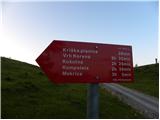 3
3 4
4 5
5 6
6 7
7 8
8 9
9 10
10 11
11 12
12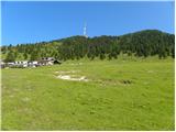 13
13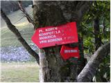 14
14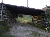 15
15 16
16 17
17 18
18 19
19 20
20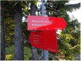 21
21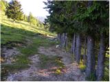 22
22 23
23 24
24 25
25 26
26 27
27 28
28 29
29 30
30 31
31 32
32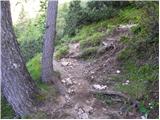 33
33 34
34 35
35 36
36 37
37 38
38 39
39 40
40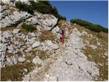 41
41 42
42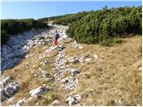 43
43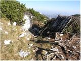 44
44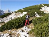 45
45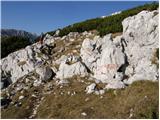 46
46 47
47 48
48 49
49 50
50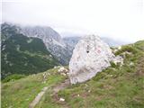 51
51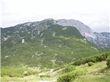 52
52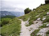 53
53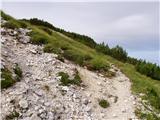 54
54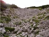 55
55 56
56 57
57 58
58 59
59 60
60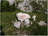 61
61 62
62 63
63 64
64 65
65 66
66 67
67 68
68 69
69 70
70 71
71 72
72 73
73 74
74 75
75 76
76 77
77 78
78 79
79 80
80 81
81 82
82 83
83 84
84 85
85 86
86 87
87 88
88 89
89 90
90 91
91 92
92 93
93 94
94
Discussion about the trip Planina Jezerca - Kalška gora (via planina Koren)
|
| velkavrh29. 08. 2013 |
I do this path every year in the dry season and did it this year too. We won't meet many hikers on this path though. In fog better not go via Kalci, because orientation in the karst world of Kalci is difficult. If going there for the first time to Kalška gora one must watch the marks, because we miss them easily.
|
|
|
To post a comment you must log in:
If you do not yet have a username, you must first
register.