Planina Podvežak - Lučki Dedec (via Kocbekov dom)
Starting point: Planina Podvežak (1564 m)
| Latitude/Longitude: | 46,33190°N 14,67260°E |
| |
Route name: via Kocbekov dom
Walking time: 3 h 15 min
Difficulty: partly demanding unmarked way
Elevation gain: 459 m
Elevation difference along the route: 635 m
Map: Kamniške in Savinjske Alpe 1:50.000
Recommended equipment (summer):
Recommended equipment (winter): ice axe, crampons
Views: 55.428
 | 3 people like this post |
Access to starting point:
First, we drive to Luče, then we continue driving into the Podvolovjek valley (towards Kamnik and Kranjski Rak). At the road marker between 11 and 11.5 km, we will arrive at a smaller intersection, where the road towards the Planinšek farm and mountain pastures Podvežak, Ravne and Vodole branches off to the right (the turn-off is marked). We head onto this initially still asphalted road, which we follow at the intersections in the direction of the mountain pasture Podvežak. After a relatively long and in the upper part also poorer macadam road, we will arrive at the parking lot below the mountain pasture Podvežak (at the starting point there is a barrier and numerous hiking signposts).
From Kamnik we drive towards the Črnivec pass, but only to the intersection, where the road towards Kranjski Rak branches off sharply to the left (the turn-off is marked and is located only 500 m before the mentioned pass). At the intersection at Kranjski Rak we continue straight on the main road, which starts descending into the Podvolovjek valley. In the mentioned valley, we will only 100 m past the Gams bar arrive at an intersection, where the road towards the Planinšek farm and mountain pastures Podvežak, Ravne and Vodole branches off to the left (the turn-off is marked). Further, follow the above description.
Route description:
From the parking lot, we head onto the footpath (or road) in the direction of the mountain pasture Podvežak. Both the road and the footpath, which during the ascent crosses a forest road, bring us in 15 minutes of moderate ascent to the shepherd's hut on the mountain pasture Podvežak, from which a beautiful view opens towards Rogatec and Lepenatka.
From the mountain pasture we continue on the marked but initially poorly visible path, which soon enters the forest. The path through the forest ascends somewhat more steeply, then transitions into a smaller bare valley, above which it completely flattens. This is followed by a few minutes of crossing the slopes below the side ridge of Deska, then the path brings us to a less noticeable junction, where an unmarked path branches off to the left towards Deska and Vodotočno jezero. We continue straight on the marked path, which descends into a pleasant grassy plain, then turns somewhat to the right and ascends through a belt of dwarf pines. At the top of the ascent, the path from the mountain pasture Vodole joins from the right, and we continue left, cross the grazing fence and after a few more steps arrive at Inkretov studenec, which is located just a few meters off the path.
This is followed by only a slight ascent, then the path flattens again and brings us below the relatively steep and, in snow, avalanche-prone slopes of Tolsti vrh. A little further, the pleasant path brings us to a marked junction, where we continue slightly left towards Korošica (slightly right the chapel on Molička peč (mountain pasture)). The path ahead crosses the slopes below Tolsti vrh for a while longer, then transitions onto the plateau-like terrain of Dleskovška planota, which is riddled with numerous sinkholes and pits. The path, continuing with some shorter ascents and descents, then quickly brings us to a junction, where the path from Robanov kot and the mountain pasture Ravne joins from the right.
We continue towards Korošica on the path that ascends transversely to the saddle between the less known Koroški vrh on the left and Mala Ojstrica on the right. We continue straight downhill (left Prag, right Ojstrica via Mala Ojstrica) on the marked path, which starts descending towards Korošica. After a few minutes of descent we step onto the expansive grassy slopes of Korošica, along which we then walk in a few minutes to the mountain hut.
From Kocbekov dom we continue left towards Podvolovjek and Kamniška Bistrica on the path which first gently then moderately ascends towards the Prag pass. After approximately 15 minutes of walking we step onto the mentioned pass, and we follow the marked path for another 10 or so meters to the place where the signs for Lučki Dedec direct us right onto an unmarked path.
At the place where we notice the signs for Lučki Dedec we leave the marked path and continue the ascent on an initially clearly visible trail. The path ahead continues through a small valley, then turns right and ascends steeply. Further on, the trail, along which there are numerous cairns, starts to fade, but in good weather this causes us no orientation problems. This is followed by an ascent over smaller scree terrain, then the path transitions onto grassy slopes surrounded by dwarf pines. Here we will already notice one of the three peaks of Lučki Dedec on the right, and we continue straight on the path which brings us to the main ridge. On the ridge we continue slightly left and the path quickly brings us past the second subpeak to a large meadow, up which we ascend in a few steps to the precipitous summit.

Photos:
 1
1 2
2 3
3 4
4 5
5 6
6 7
7 8
8 9
9 10
10 11
11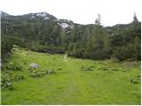 12
12 13
13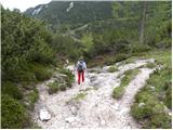 14
14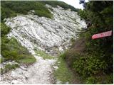 15
15 16
16 17
17 18
18 19
19 20
20 21
21 22
22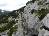 23
23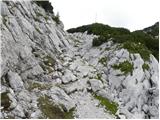 24
24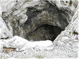 25
25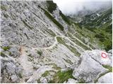 26
26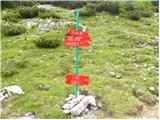 27
27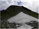 28
28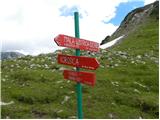 29
29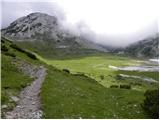 30
30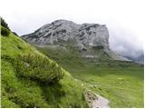 31
31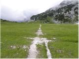 32
32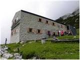 33
33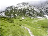 34
34 35
35 36
36 37
37 38
38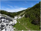 39
39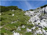 40
40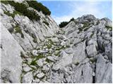 41
41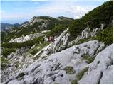 42
42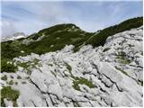 43
43 44
44 45
45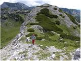 46
46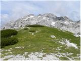 47
47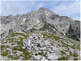 48
48
Discussion about the trip Planina Podvežak - Lučki Dedec (via Kocbekov dom)
|
| Gost2. 10. 2006 |
Real grandpa: at first glance steep... and demanding, with the right approach though quite obliging and friendly.
|
|
|
|
| Gost16. 09. 2007 |
On 15.9.2007 my husband and I were already the second time this month at Korošica, as on 1.9. there was the opening of the renovated hut and there was no opportunity to enjoy the beauty of our mountains. Then we climbed Ojstrica and left quickly, as there was no space and some had already taken it a bit under their wing. So we wanted to return. And so we set off again from Planina Podvežak, to Molička peč, to Kocbekov dom and then to Dedec along the described path, it was wonderful alone on the plateau, enjoying the silence, on Ojstrica a real crowd.
Return past Vodotočnik, back along the unmarked path and it was beautiful. Good luck!
|
|
|
|
| Gost22. 11. 2007 |
We think that on Korošica they have him under the roof far too often!!! Sp. Savinjšani
|
|
|
|
| damjan golič10. 07. 2010 |
Today, my dearest and I climbed from Planina Podvežak past Kocbekov dom to Lučki Dedec. The path to the hut is wonderfully marked and signposted. We left the car a bit lower; the parking lot was full of cars, and even a bus can reach the starting point. I would like to thank three hikers who helped us with useful information so that we summited Dedec via pathless terrain without issues and returned safely to the valley. THE DAY WAS BEAUTIFUL!
|
|
|
|
| LukaSLO22. 11. 2010 |
The path to Kocbekov dom on Korošica is very well marked. To Lučki Dedec problems can arise if you stray from the ideal path, so caution is advised.
|
|
|
|
| muzikant AT8. 08. 2011 |
Hi. I'm interested if Lučki Dedec has a logbook and stamp.
Thanks for the info in advance. And good luck
|
|
|
|
| otiv8. 08. 2011 |
I think there is neither one nor the other. Maybe they have a stamp at Korošica.
Nice regards!
|
|
|
|
| muzikant AT8. 08. 2011 |
otiv-Thanks for the info. And good luck
|
|
|
|
| redbull12. 02. 2012 |
Hello
I'm wondering if it's possible in these conditions to go to Lučki Dedec via this path, if avalanche danger is high and if you also need an ice axe for easier walking. Now after February 15th.
Thanks in advance
Best regards
Dejan
|
|
|
|
| otiv12. 02. 2012 |
Dejan! Winter doesn't end in the mountains on February 15th, true winter conditions persist well into spring. These days, cornices are definitely causing problems and there are always many of them, crossing them is real torment if you're on foot. An ice axe is part of winter gear and an obligatory part of a mountaineer's equipment. Once an ice axe saved me from trouble by allowing me to move a log with it so I could return to the valley, so it's never superfluous.
The path to Lučki Dedec is not problematic if conditions are normal.
Good luck!
|
|
|
|
| CarpeDiem2475. 03. 2012 |
I would just ask how much time to allow from Kocbekov dom at a medium pace to reach Lučki Dedec?
Would the "direct" ascent to it, meaning somewhat more to the left, not straight into the wall, require more than e.g. 2nd degree of climbing, if anyone has tried it, I'm just curious? 
|
|
|
|
| otiv5. 03. 2012 |
In summer approx. 40 min, that's via the saddle where the marked path is. For your variant I don't know, as I'm not such a chamois as you.
|
|
|
|
| Gdu bo meni reku svinja18. 10. 2012 |
Today, with a friend, I visited this really interesting peak. We made a circular route with starting point Podvežak, first directly to the summit, then also for a sip of bitter satisfaction at Kocbekov dom, which by chance was still open today.
At the hut we met the only hikers that day, where we really had a good laugh. When she asked us where we had been and we said on Dedec she directly blurted "boys, but on Babnica it’s surely more fun!" [js>
|
|
|
|
| črnozanohtam16. 11. 2012 |
Hi.
I'm interested in what the road to Podvežak is like, especially the macadam part? Is it possible to leave the car somewhere along the path if it's too eroded?
Thanks.
|
|
|
|
| katja8710. 06. 2013 |
Yesterday, 9.6.2013, we set off along this path to the summit of Lučki Dedec. The path is passable, although there is still a lot of snow. A firm track has been made, so winter gear is not necessary.
We did the tour: Planina Podvežak - Planina Korošica - Lučki Dedec - Kocbekov dom na Korošici - Mala Ojstrica - Planina Podvežak.
The path to Lučkega Dedec is unmarked, but due to frequent cairns it's impossible to miss. Only some cairns in between are still under snow, which doesn't pose a major obstacle.
Kocbekov dom is open but under renovation, so we couldn't enter.
Pictures from the hike can be viewed on the website of Planinsko društvo Matica Murska Sobota: http://www.mojalbum.com/pdmaticams/20130609-lucki-dedec-in-mala-ojstrica/lucki-dedec/20846480
|
|
|
|
| Kokta15. 07. 2013 |
Planina Podvežak - Planina Korošica - Lučki Dedec - Kocbekov dom na Korošici - Mala Ojstrica - Molička planina - Planina Podvežak. Weather super
|
|
|
|
| seinfeld13. 10. 2013 |
Today to Lučki Dedec via the saddle between Deska and Tolsti vrh and past Vodotočno jezero. The path to Dedec is densely marked with cairns and orientation is easy. When we turn off the marked path at the threshold it's only half an hour to the summit. For the whole path from Planina Podvežak we needed two hours and ten minutes.
|
|
|
|
| Goru26. 05. 2016 |
Hi, I'm interested in how the snow is on the ridge and Dedec?
|
|
|
|
| marko hribinet4. 04. 2017 |
Hi. On Saturday I planned to go up there. Can someone please tell me what the conditions are like. How much snow, is there a track? Since it's an unmarked path, is it hard to follow? Also, are crampons and ice axe needed or will small crampons suffice? Thanks!
|
|
|
|
| jvali3. 08. 2018 |
On Monday, 30.7.2018 from Podvežak past Vodotočnik lake to Lučki Dedec. Nice trail, especially the unmarked section to the summit is unique, interesting, a bit of climbing on good rock, first time on the mountain. Summit very spacious, panoramic, green, but also exposed. Back to the Planina via the upper trail, not via Korošica, because the view of the hut ruins is sad enough and I stared at it last time when returning from Ojstrica. No living soul on the way up and down. At the Planina pleasant chat with the caretaker and excellent coffee!
|
|
|
|
| jvali3. 08. 2018 |
I posted the comment a bit too quickly and it went without pictures. Hope it works this time.
|
|
|
|
| garmont3. 08. 2018 |
You can't add pictures here.  You can only comment on the trip described above. You can only comment on the trip described above.
You can add pictures in the "Current conditions" thread.
|
|
|
|
| jvali3. 08. 2018 |
garmont: thanks. True, we learn something new every day. I opened a new thread and put the description there and uploaded the pictures. Regards, Valerija
|
|
|
|
| skiro1231. 08. 2019 |
I think the approach from the S side is somewhat easier if you go past Kocbekov dom. Follow the path heading towards W or Srebrno sedlo and Planjava (initially not very visible due to many rocks, later well-trodden). After approx. 1/4 hour of walking, a clearly visible path turns left to the saddle below Lučki Dedec. From the saddle, ascend the meadow to the summit - here the path is less visible but at least not orientationally demanding, as you just follow the slope and know the summit is on the left edge. The path is also marked on OpenCycleMap.
|
|
|
|
| J.P.2. 09. 2022 17:21:00 |
After the pass we head to the first visible path to the right. There are no additional markers anymore. To the summit with wonderful views cairns and a bit of orientation then lead us. Kocbek unfortunately still hasn't received renovation. Lp
|
|
|
|
| Enka13. 08. 2024 20:00:13 |
From the sign in picture 38 only a stump is left, at which you need to follow the path to the left if coming from Vodotočno jezero, or to the right according to the described approach. When the path disappears, the route is excellently cairn-marked, so it's impossible to miss.
|
|
|
|
| nekdo_nekje14. 06. 2026 15:03:18 |
From the valley to the trailhead there is quite a drive by car. I was up there yesterday (13.6.) and did not notice a box with a logbook anywhere, though I did not particularly try to search for it either. As "Enka" says above that there is no longer a stake, I inform that it has been successfully replaced with a new wooden board, so the path is hard to miss. The path description also does not mention one of the smaller points of interest along the way. When we start ascending the last part of the path on "karst-like" terrain we will see two smaller caves (oči dedca) and a sign with an inscription along the path. Have a good trip!⛰️⛰️
|
|
|
To post a comment you must log in:
If you do not yet have a username, you must first
register.