Planina Zapleč - Krasji vrh (via Koluji)
Starting point: Planina Zapleč (1201 m)
| Latitude/Longitude: | 46,28330°N 13,63080°E |
| |
Route name: via Koluji
Walking time: 2 h
Difficulty: easy marked way
Elevation gain: 572 m
Elevation difference along the route: 572 m
Map: Julijske Alpe - zahodni del 1:50.000
Recommended equipment (summer):
Recommended equipment (winter): ice axe, crampons
Views: 36.225
 | 2 people like this post |
Access to starting point:
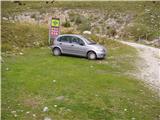
From Tolmin or Bovec we drive to Kobarid, from there we follow the road in the direction of Drežnica (the turn-off is from the Kobarid bypass). We continue over the bridge across the Soča River and immediately after the bridge we turn left in the direction of Drežnica. In Drežnica we come to an intersection, where the road to the village Magozd branches off to the left, and we continue a little further to the next intersection, where we turn left in the direction of Drežniške Ravne. The road then brings us to an intersection in Drežniške Ravne, where we turn right uphill in the direction of Krasji vrh. At the next intersection we again turn right and follow the road to the water trough, where the asphalt ends. We then follow the macadam road for quite a few kilometers to the parking lot by the road in front of the TNP sign and the grazing fence.
Route description:
From the parking lot in front of the TNP sign we continue on the macadam road ahead, which below the slopes of the ridge Krnčica soon brings us to an intersection on the mountain pasture Zaprikraj. Here we continue left on the worse lower road, which in a few steps brings us to the hamlet on the mountain pasture.
From the buildings on the mountain pasture we continue on a path that slightly ascends in the direction of Krasji vrh. The path then at the end of the mountain pasture crosses a grazing fence and through the forest brings us to a clearing where a hunting cottage stands. The path ahead continues on a cart track, which goes back into the forest and soon brings us to a junction. We leave the cart track and head left slightly downhill. There follows a few minutes of almost level walking, then we join the footpath from Drežniške Ravne. The path then moderately ascends on slopes covered with forest. The path ahead crosses a clearing where high grass grows and then ascends again to a junction at 1450 m.
We continue left in the direction of the kolujev and follow the path, which for 15 minutes proceeds without major changes in elevation. After 15 minutes the path brings us out of the forest and begins to moderately ascend on the summit slopes of Krasji vrh. Soon the path brings us to a junction, where we continue right, left to koluji 10 min. The path ahead becomes quite overgrown and ascends among high grasses all the way to the top.

Photos:
 1
1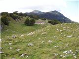 2
2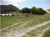 3
3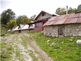 4
4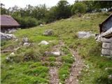 5
5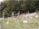 6
6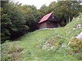 7
7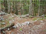 8
8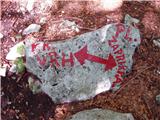 9
9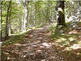 10
10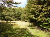 11
11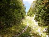 12
12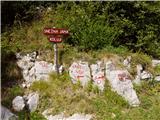 13
13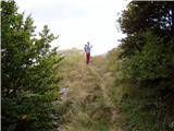 14
14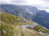 15
15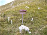 16
16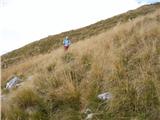 17
17 18
18 19
19
Discussion about the trip Planina Zapleč - Krasji vrh (via Koluji)
|
| GITA29. 07. 2009 |
Today we climbed Krasji vrh with the family. The road to the pasture is in pretty bad condition, so we soon gave up, parked by the road and just found the junction of the trail from Drežniške ravne and continued on foot along the trail past the kolujev. This extended our ascent by almost an hour, but no problem. The trail is really nice, quite easy, without steep ascents, nowhere exposed, well marked, shady, which is great in such a hot day, in short ideal also for families with children. The only slight disappointment awaited us at the summit itself. A herd of sheep occupied the summit and completely "sheepified" it  , so there was almost no clean place to step, let alone put down the backpack. So we continued without a break to the other side past Snežna jama back to the valley. Especially along the return trail, numerous remnants of the First World War can be observed, which particularly "stirs" children's imagination. In the end, a great trip! , so there was almost no clean place to step, let alone put down the backpack. So we continued without a break to the other side past Snežna jama back to the valley. Especially along the return trail, numerous remnants of the First World War can be observed, which particularly "stirs" children's imagination. In the end, a great trip!
|
|
|
|
| pohodnik0112. 08. 2009 |
You don't need to drive to the alpine pastures by car. We also went to Krasji vrh, we parked in Drežniške Ravne (the road there is asphalted). The hike through the beautiful landscape took less than 3 hours. As for sheep and goats, we're never disappointed when we encounter them. And that everything is full of droppings is normal. We (and others too) moved a bit lower and could sit and lie down and unload our backpacks because it was all clean. It's a shame that there are human feces and various drink bottles on the hiking trails. That's DISAPPOINTING, not the droppings from livestock!
|
|
|
|
| Kozorog12. 08. 2009 |
Pohodnik01 well I was also with kids to Krasji vrh (and also to some other  ). Nice trip, and I think there's no problem with the "start" either from Drežniške Ravne or from the alpine pasture. The problem arises when some write how they did the ascent even from the "pasture" and describe the path and duration... when a person plans a trip suitable for the age of the children then you choose the starting point so that the ascent and descent the kids can manage. I don't know if you read some statement from parents how they "took" six-year-olds to Storžič via "Žrela" and it took them 6 hours. Such trips are a bit beyond me so I don't discuss parental responsibility or irresponsibility. As for human feces, that bothers me a lot and I'm disappointed too!!! Livestock droppings bother me less... but if you've been maybe... say to Tolsti vrh then that's a nice example of handling such matters... Well if you haven't been, I'll tell you that the summit is appropriately fenced and livestock droppings don't reach the box with the stamp or logbook ). Nice trip, and I think there's no problem with the "start" either from Drežniške Ravne or from the alpine pasture. The problem arises when some write how they did the ascent even from the "pasture" and describe the path and duration... when a person plans a trip suitable for the age of the children then you choose the starting point so that the ascent and descent the kids can manage. I don't know if you read some statement from parents how they "took" six-year-olds to Storžič via "Žrela" and it took them 6 hours. Such trips are a bit beyond me so I don't discuss parental responsibility or irresponsibility. As for human feces, that bothers me a lot and I'm disappointed too!!! Livestock droppings bother me less... but if you've been maybe... say to Tolsti vrh then that's a nice example of handling such matters... Well if you haven't been, I'll tell you that the summit is appropriately fenced and livestock droppings don't reach the box with the stamp or logbook and you enjoy the view from the top. and you enjoy the view from the top.
|
|
|
|
| ksena6. 06. 2010 |
From the parking lot at the trough above Drežniške ravne I took the shortcut that someone took time to mow (commendable), crossed the road leading to Planina Zaprikraj and entered the cool forest. The thermometer at 8.00 when I started already showed +15. Good that almost three quarters of the path is through the forest, so I wasn't afraid of "heat stroke". Walking in the cool forest was pleasant. At the path junction I chose the circular variant, so I took the direction towards the kolujev, from the top I returned past Snežna jama. I was the only one at the top, on the way back I met a larger group of Italians, and also some Slovenes. Obviously this mountain, until recently poorly visited, has been discovered by many people. Krasji vrh is a worthwhile viewpoint above Drežnica in all seasons.
|
|
|
|
| dsusnik7. 07. 2010 |
On Saturday 3.7.2010 we were at Krasji vrh. Nice path and nice weather. However, I do not recommend driving to Planina Zaprikraj by car, because it is really in poor condition. Especially for vehicles with low ground clearance!
lp
|
|
|
|
| Matjaz_6514. 08. 2010 |
To Planina Zapleč you can also go via the path from the water trough where the sign directs us right into the forest ... number 5 in my photos
this extends the ascent by an hour ... but we avoid the bad road 
by the way, you can also see slap curk ... which is 15 minutes off the path
|
|
|
|
| katja876. 05. 2013 |
On Sunday 5.5. we took this path to Krasji vrh. We parked at Planina Zapleč, but the gravel road is very bad, so I recommend everyone without a 4x4 to park below in Drežniške Ravne.
Planina Zaprikraj is wonderful, the entire path is interesting. There's some snow in between and we even cross snow in one gully, but there's already a nice track made, so no problem passing.
At the summit we enjoyed magnificent views, so I recommend this tour to everyone
Photos from the hike can be viewed on the website of Planinsko društvo Matica Murska Sobota: http://www.mojalbum.com/pdmaticams/20130505-krasji-vrh/krasji-vrh/20747257
|
|
|
|
| slavkoo13. 07. 2015 |
Maybe someone knows in what condition the road from Drežniške ravne to Planina Zapleč is. Thanks.
|
|
|
|
| maregol16. 07. 2017 |
Maybe someone knows the condition of the road from Drežniške ravni to Planina Zapleč. Thanks.
|
|
|
|
| Smetar16. 07. 2017 |
You can get there with a car but you need to be careful, as some sections are torn up (ditches)... personally I prefer going on foot rather than by car.
|
|
|
|
| Lunca29. 07. 2017 |
Does anyone have fresh info about the road to Planina Zapleč?
|
|
|
|
| KarmenT27. 10. 2021 10:17:06 |
The road is covered with concrete in several sections, in between more or less torn up. There are some larger potholes, but in places it's quite "ideal". We left the car at the trough above Ravne, but people were driving on the road with regular passenger cars, small and large, it didn't look like they had problems. On the concrete sections there are also proper "channels" for drainage. Otherwise very beautiful places, full of peace and autumn colors.
|
|
|
|
| mirank27. 10. 2021 15:51:22 |
There has always been the worst road section there, about 500m ahead from the mentioned trough-that first climb anyway.
|
|
|
|
| miranm2. 06. 2022 10:54:27 |
Hello,
I'm interested in the current drivability of the road from korit to planina Zapleč - by car.
regards
Miran
|
|
|
|
| eve2. 06. 2022 12:24:44 |
The road is normally drivable, checked on Sunday 29.5.
|
|
|
|
| miranm3. 06. 2022 09:59:10 |
Thanks for the information.
|
|
|
|
| jprim3. 06. 2022 19:50:26 |
Yes, what does "normally passable" mean. That certainly doesn't apply to this road.
Need to watch out for rocks, holes, often need to navigate...
Yes, you can get to the alpine pasture, but not normally.
|
|
|
|
| padez6. 06. 2022 14:14:22 |
Once I already wrote that this road is in very poor condition. It was a few years ago and it seemed to me then that in that first bend above the trough it was deliberately damaged. When I got there, a deep ditch awaited me and I had to reverse quite far back. Of course you can't turn around there.
The second time I was more careful and went to check beforehand what was up.
I found out that that ditch was deliberately dug and in it also "quite coincidentally" some large stones. It was immediately clear to me. Once there were also some bivouacs for hikers on Planina Zaprikaj, which greatly facilitated crossing Polovnik. Well, that's gone too...
|
|
|
|
| BorStenar20. 11. 2022 13:11:24 |
Hi, what are the conditions like for Krasji vrh in winter?
LP
|
|
|
|
| darinka420. 11. 2022 13:33:13 |
Depends on how much snow falls. This year I think December 12th there will be the annual hike. Then the track is made. I remember last year the hike was cancelled. There was quite some snow. I remember it was trampled on the winter route which goes a bit differently.
|
|
|
|
| BorStenar20. 11. 2022 14:50:37 |
Thanks for the information.
|
|
|
|
| padez20. 11. 2022 16:54:52 |
Since koluje are mentioned, I'm curious what that is? Maybe those concrete rings in the middle of the slope? If that's it, what purpose did they serve during the First World War? Thanks for the answer...
|
|
|
|
| darinka421. 11. 2022 22:46:52 |
On December 4th, there should be a hike from Drezniske Ravne to Krasji vrh.
|
|
|
|
| miri21. 11. 2022 23:04:37 |
@padez artillery positions.
|
|
|
|
| mirank21. 11. 2022 23:17:33 |
Miri, if you allow, I would supplement that these are positions of an anti-aircraft battery. Probably the weapon had no possibility of horizontal movement, so it slid on a circle. A well-preserved example of such a position is near Cerje - partially the markings on the concrete are visible
|
|
|
|
| miri21. 11. 2022 23:22:01 |
@mirank - excellent explanation.
|
|
|
|
| padez22. 11. 2022 14:23:57 |
Where does the name or word koluji come from? In my opinion these cannons are adapted weapons for easier and faster movement or tracking of aircraft. Otherwise they were already shooting with time-fused shells back then, because with direct hits they wouldn't have shot down even one aircraft.
|
|
|
|
| darinka413. 12. 2022 20:35:48 |
Today we made a track on this side to the top. Two more hikers came behind us, who descended past the snow hole.
|
|
|
|
| matej29. 09. 2023 10:25:54 |
Maybe someone knows the condition of the road from Drežniške ravne to Planina Zapleč. Thanks.
|
|
|
|
| ljubitelj gora30. 09. 2023 13:15:35 |
For high cars, SUVs, park at the end of the asphalt and that's it.
|
|
|
To post a comment you must log in:
If you do not yet have a username, you must first
register.