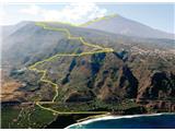
Playa del Socorro - Pico del Teide
Starting point: Playa del Socorro (0 m)
| Latitude/Longitude: | 28,39460°N -16,60170°E |
| |
Walking time: 12 h
Difficulty: easy unmarked way
Elevation gain: 3718 m
Elevation difference along the route: 3718 m
Map:
Recommended equipment (summer): lamp
Recommended equipment (winter): lamp
Views: 7.440
 | 5 people like this post |
Access to starting point:
We must arrive on the island of Tenerife and proceed to Playa del Socorro beach, where the described trail begins.
Route description:
Ruta 0-4-0 symbolizes the ascent from sea level to 4000 m.a.s.l. and descent back. In reality, we fall short of that altitude by less than 300 meters.
From Socorro beach, we begin ascending a steep asphalt road to the first intersection with the highway. We continue right along it for about 100 m, then turn left onto a gravel track that later becomes a paved road. At the first intersection, we merely cross the street, and at the next (Calle Tigaiga) turn left. We continue another 300 m or so, then at the intersection by the chapel on our left, we proceed along Camino Vueltas de Icod El Alto street to reach the main TF342 road. We continue on the footpath to Mirador el Lance viewpoint. Above us, Mirador de la Corona viewpoint with numerous transmitters is clearly visible throughout, serving as an orientation point since the trail leads past it. Upon reaching it, a view of the peak opens up. Here we leave the urban environment and begin ascending forest roads and paths. We always head uphill. THERE ARE NO MARKINGS; where they exist, they point to other places not in our direction. When in doubt, choose the steepest path. After a long hike through the forest, we climb above the treeline onto a rocky plateau with sparse scrub. A view towards the volcanic cone opens again. We continue on the path, turn left at the chapel and descend past a wooden fence, crossing a sandy valley. Keep left. At the first intersection, turn right onto path 22 and follow it to path 7, then continue on that. When we reach just below the base of the steep section, no doubts remain. Here the path from the parking lot at around 2400 m joins, and the number of hikers increases immediately. We ascend steeply towards the summit past Refugia Altavista (3250 m) until we reach the control point (3550 m), where we must show the permit and ID document. Without it, we can only ascend to the summit and descend before 9 a.m. The summit offers fine views in all directions. Steam rises from hot rocks, there is a sulfur smell, and a large crowd of people who arrived by cable car.
Descend the same route.
WARNINGS:
- A special permit (Permiso) is required to visit the summit itself; it is free but must be obtained in advance (online), as they will not allow us up without it. Properly assess the ascent start time to arrive at the summit on time - the permit is valid for 2 hours! The trail is unmarked, which may extend hiking time.
- The trail is technically undemanding but nearly 30 km long, requiring over 3700 m of elevation gain. The hike can be shortened by using car, bus, and cable car for parts.
- Cable car available for descent to the valley (27 eur). A bus also runs down from the lower cable car station, but beware not to miss the last bus, which departs a full hour before the last cable car.
- Temperature typically drops by about 25°C en route to the summit, so dress appropriately.
- Protect against the sun and carry sufficient water. If not pre-registered, do not expect meals or lodging at Altavista refuge. Overnight requires reservation; only a vending machine with snacks and drinks available.

Photos:
 1
1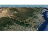 2
2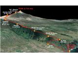 3
3 4
4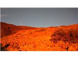 5
5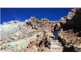 6
6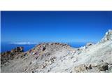 7
7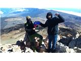 8
8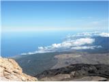 9
9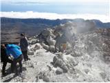 10
10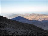 11
11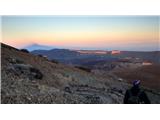 12
12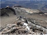 13
13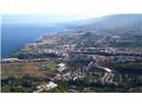 14
14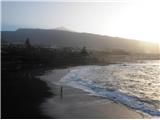 15
15
Discussion about the trip Playa del Socorro - Pico del Teide
|
| lino3. 02. 2016 |
Roklun, very interesting trip to an altitude of just under 1000 meters above Triglav. Judging by the photos, it's a hike for hikers with a mountaineering soul.
Is the face protection in photo 8 for smoky air or because of the cold?
In photo 10 you can also see some mists. Is it fog, dust, or even sulfur fumes from the extinct volcano?
Nice trip description and interesting photos. Regards
|
|
|
|
| ločanka3. 02. 2016 |
I also climbed this beautiful peak with beautiful surroundings a couple of years ago. At the top it was very cold and windy, we smelled sulfur. We ascended the longer path and stayed overnight, for the descent we used the cable car.
I recommend everyone to visit this peak, as without this achievement there is no true experience of the Canary Islands.
|
|
|
|
| Bojan_A3. 02. 2016 |
Thanks for the good idea! Slovenia is already covered. I want to see more descriptions of mountains from various tourist and distant places.
|
|
|
|
| roklun4. 02. 2016 |
Lino, you're right, it's quite a challenging hike. Precisely that accumulated elevation gain that we set out to overcome in one go excited me so much that I wrote my first post for the hribi.net site, which I also like to visit. I'm really glad for the positive response!
Despite good fitness, my legs hurt for three more days. My buddy had his face covered more for prevention, against high-altitude sun. It was quite windy, temperature below freezing - sleepless night also contributes to feeling frozen. We inhaled dust at altitudes between 2000 and 2600 meters, where the path runs on gravelly ground and the wind was blowing sand everywhere. Those mists are indeed sulfur fumes ... Regards
|
|
|
|
| Pi_is_exactly_34. 02. 2016 |
Out of curiosity, I browsed some news and found an article that mountain runner Agustí Roc set the record for this trail in 2013 (April). He improved the previous record by 40 minutes, completing the ascent in 3h 33min. 
|
|
|
|
| roklun4. 02. 2016 |
It's true, I read that too. The colleague with whom we went up simply can't believe it ... Crazy time - REAL!
|
|
|
|
| lino4. 02. 2016 |
Roklun thanks. Really impressive figures from 0 to 3718 m above sea level. Also for me, when I admire this description at home over coffee, let alone live on the terrain. The record holder of this trail is already more robot than human. The landscape is somehow mysterious, inviting. It really pulls me there. I wish you and your friend many more such inviting trips. Best regards!
|
|
|
|
| opazovalec27. 05. 2016 |
While reading Roklun's report, many catch themselves wanting to try something like that too. My wife and I were back on Tenerife in May, and due to logistics, repeating the whole trail is really tricky since returning to the valley in the evening is impossible. We opted for an adapted version from the coast to the summit. We split the crew in half. The cycling part started on the bike just above the coast, the car part moved to the starting point from the most suitable spot at 2300m. We securely locked the rented bike in the car and headed to El Teide. The more cautious car part turned around about 200m below the summit due to the storm, the cycling part went almost on their knees to the top. It blew his cap off. The summit photo is thus from last year as taking one this year would be impossible. The cable car stopped running already during the day, so no one checked our "no-permits". Let the GPS track be proof of the ascent to the summit.
|
|
|
|
| DaKa24. 05. 2018 |
I'd like to warn everyone traveling through the Zoja Challenge agency to be careful. We returned from Tenerife and had a very bad experience. Tenerife is a very nice island though.
|
|
|
To post a comment you must log in:
If you do not yet have a username, you must first
register.