Plaz Črlovec - Kukova špica (via Gulce)
Starting point: Plaz Črlovec (920 m)
| Latitude/Longitude: | 46,43110°N 13,87840°E |
| |
Route name: via Gulce
Walking time: 5 h
Difficulty: difficult unmarked way
Elevation gain: 1507 m
Elevation difference along the route: 1515 m
Map: TNP 1:50.000
Recommended equipment (summer): helmet
Recommended equipment (winter): helmet, ice axe, crampons
Views: 69.216
 | 9 people like this post |
Access to starting point:
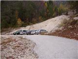
We leave the Gorenjska motorway at the Hrušica exit and follow the road ahead in the direction of Kranjska Gora. Just a little before the village of Dovje, the road to Mojstrana (Vrata, Kot and Krma) branches off to the left from the main road. We follow the road ahead in the direction of Vrata Valley and drive past the Koča pri Peričniku mountain hut to the spot where a large landslide crosses the road. Here we park on one of the parking areas by the road.
Route description:
On the lower side of the landslide we will notice a footpath which at first ascends gently along the landslide named Črlovec. Soon the path starts to ascend more steeply and brings us between both torrential gullies (Mali and Veliki Črlovec). The path then ascends steeply in zigzags mostly through dense forest. After two hours of walking, we step onto the transverse path (Poldov rovt - Vrtaško sleme), where we continue left. Further, we descend a few meters and cross the gully of Veliki Črlovec (in wet conditions dangerous for slipping). The path then still crosses the slopes towards the left and brings us out of the forest onto scree vegetated with dwarf pines. Here we need to pay attention, because the path to Kukova špica leaves the transverse path and continues right upwards (the turn-off is not marked, exceptions are the cairns, which snow avalanches often destroy). The path ahead ascends partly on grassy slopes, partly on scree. Higher, the path ascends steeply over a shorter rocky step and then brings us to the meadows below the saddle Čez Gulce. To here we need good 4 hours.
On the saddle we turn right and along a quite steep path, which is not too exposed, we reach the summit in good 30 minutes of additional walking.
In the upper part there is a high risk of falling rocks. The entire path is exposed to snow avalanches! In the middle part, because of numerous small paths, it is hard to find the right path.

Along the route: Čez Gulce (2257m)
Photos:
 1
1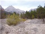 2
2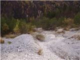 3
3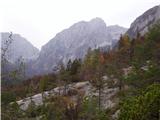 4
4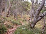 5
5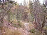 6
6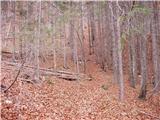 7
7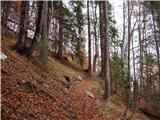 8
8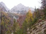 9
9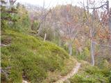 10
10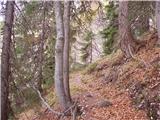 11
11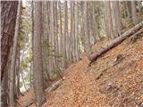 12
12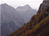 13
13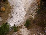 14
14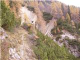 15
15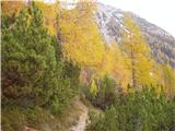 16
16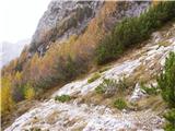 17
17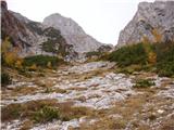 18
18 19
19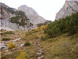 20
20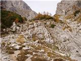 21
21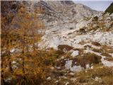 22
22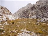 23
23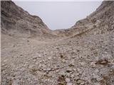 24
24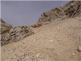 25
25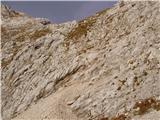 26
26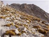 27
27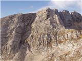 28
28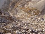 29
29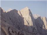 30
30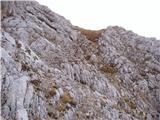 31
31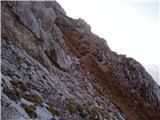 32
32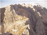 33
33 34
34 35
35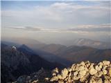 36
36
Discussion about the trip Plaz Črlovec - Kukova špica (via Gulce)
Show older messages
|
| Gost10. 07. 2006 |
The tour is only for the experienced, you also need to have a bit of a pathfinder in you. The mighty Kukova špica rewards you at the top with a beautiful view, the Amphitheater at your fingertips.
|
|
|
|
| Gost23. 09. 2007 |
Very nice, especially in good weather beautiful view.
|
|
|
|
| andrej jerina12. 07. 2008 |
My partner Franci and I also did the ascent to Kukova špica. To the description I'd add this:
At around 1500 m, when the described trail brings us to the clearing, there are several trails crossing. Here we must keep left all the way, as the right one leads to Vrtaška planina via Mali Črlovec (landslide). A well-trodden path in slight descent brings us to Veliki Črlovec landslide, which we cross without issues, above it we already see a nice trodden path to continue. Above the tree line the path is visible but gets lost several times, as the landslide took almost all cairns. I placed some today, others will be placed by other hikers. Today's curiosity was a mouse ruling under the big cairn on top of Kukova špica. There's a logbook at the top, no stamp.
I'd also like to ask all mountaineering friends. Since fog caught us at the top, we couldn't photograph the Amphitheater. I'd kindly ask some like-minded hiker to send me a nice photo of the Amphitheater to ajerina@gmail.com (just for personal album). Thanks in advance. LP Andrej
|
|
|
|
| malavc26. 07. 2008 |
WITH MILAN SVA
WE
YESTERDAY FROM VRAT-PERIČNIK SET OFF TO KUKOVA ŠPICA, THE PATH IS OK. THERE ARE ALREADY QUITE A FEW NEWLY PLACED CAIRNS, SO THE DIRECTION IS WELL VISIBLE. THE STEEPNESS UNDER GULCE AND SUN IN THE BACK SWEATED US WELL, BUT ALL THE EFFORT WAS REWARDED WITH EXCEPTIONAL VIEWS FROM THE TOP, WHERE THE VISIT-HUNGRY MOUSE STILL REIGNS, SVA RETURNED VIA THE HUNTER'S PATH TO ALJAŽEV DOM IN VRAT, THE PATH ITSELF IS CLEARLY VISIBLE, NOT DEMANDING AND EXTREMELY PANORAMIC. ALL DAY MET ONLY ONE MOUNTAINEER AT GULCE AND LOTS OF MOUNTAIN GUARDIANS CHAMOIS. REALLY NICE PLACES FOR PEACE-LOVING MOUNTAINEERS.
|
|
|
|
| enjanez30. 08. 2008 |
Today a cairn in the fog  led me astray, so I turned uphill too early and then had plenty to do with orientation and scree in the fog. Therefore I ask everyone who thinks they must place cairns on unmarked trails to do it with common sense and a certain amount of knowledge. led me astray, so I turned uphill too early and then had plenty to do with orientation and scree in the fog. Therefore I ask everyone who thinks they must place cairns on unmarked trails to do it with common sense and a certain amount of knowledge.
|
|
|
|
| zmp213. 11. 2008 |
And who knows if the 'walkable' path from Dovški križ to Kukova špica via Škrnatarica is? Is it possible to get some GPS track?
|
|
|
|
| viharnik13. 11. 2008 |
Of course it is, but in the opposite direction it is more recommended. In winter, from the direction of Dovški križ, descent is also possible (two ice axes), with firm, settled snow! It's quite a steep gully up to below Gulce.
|
|
|
|
| zmp214. 11. 2008 |
I'm just "learning" winter hikes, so I'll do that part in summer time.
So the route Plaz Črlovec-Kukova špica (via Gulce), Škrnatarica, Dovški križ, past Šplevta to Brinova glava-Poldov rovt would be a nice 12-13 hour tour? Is it possible to do it solo without great risk?
|
|
|
|
| žl14. 11. 2008 |
This crossing is very nice and not trivial either. If you're not very experienced, I recommend an experienced mountaineer who will protect you a bit and help find the easiest passages. From Škrnatarica towards Dovški križ there is some scree that's a bit "annoying". I recommend from Šplevta to Bivak II, then ride down the scree.
|
|
|
|
| zmp214. 11. 2008 |
Thanks, I'll take all advice into account. When conditions are favorable, I'll invite you on the tour.
|
|
|
|
| skrajnik7. 07. 2010 |
This goal interests me tomorrow..
Who knows about the conditions?
Maybe some photo too?
THANKS!
|
|
|
|
| felix7. 07. 2010 |
I don't know about current conditions, but photos are on the forum-current conditions page 11 under "Kukova špica"
lp
|
|
|
|
| Bernard23. 08. 2010 |
Small note regarding the picture where the cairn is placed and we turn right towards Gulce.
At this end there are two scree fields separated by approx. 15 m of low pines. For the ascent the correct one is the SECOND scree field, where the path is found on its left side. On the first scree there is a cairn that quickly misleads... and then instead of following the more or less established path... you scramble scree. Both scree fields correctly lead to the small step below Gulce. Use the first gravelly scree for quick descent, do not recommend for ascent.
Otherwise the upper part from Gulce to the summit is well marked with cairns. So just look around and it's fine... But do not recommend ascent in fog or low cloud. Because you can easily stray.
Good luck!
|
|
|
|
| Parkeljc10. 07. 2011 |
The amphitheater is nicely visible only when we climb from the Gulce saddle after a good 10 minutes of walking below Škrnatarica.
|
|
|
|
| sin narave20. 11. 2011 |
Yesterday I headed to Kukova špica, start at Črlovec. A bit annoying because it's not marked. But unexpectedly two guys came behind me and we started together. One of them knew the path so no problem. Otherwise the path is good, only through the forest in the first part, need sharp eyes a bit. But you can't miss it. As they say: all paths lead to the top. At the top we meet two hikers, exchange a few words, then at the top, as always, viewing and admiring our mountains. Descent requires caution. Especially right from the top, where it's a bit crumbly and you can slip. No snow on the path anywhere, except tiny patches, which are not worth mentioning and not in any exposed spot. We arrive back at the start excited about the well-spent day. Happy hiking in the mountains, friends.
|
|
|
|
| Edi220. 03. 2012 |
Does anyone have any information on the conditions on the path towards Kukova špica?
|
|
|
|
| ljubitelj gora22. 03. 2012 |
I'm interested in how it is with this parking lot, which is not marked with P and in TNP you can only park at marked P spots.
|
|
|
|
| metod8. 07. 2012 |
It's worth "climbing up" to the ridge towards Škrnatarca, where the Amphitheater is in plain sight. And a tip: the slope of Gulce faces southeast, there's no water from Triglavska Bistrica onwards, so take as much as possible with you. Today luckily a pleasant breeze cooled us.
|
|
|
|
| Gregor Kelt6. 10. 2012 |
On Saturday, October 6th, I lost a sky blue McKinley softshell jacket with hood on the path. It should be somewhere at the beginning of the ascent.
I kindly ask the finder to send the jacket to: Beleharjeva cesta 17, 4208 Šenčur. I will cover all shipping costs.
|
|
|
|
| jedriličar13. 08. 2013 |
Yesterday on KŠ. Ideal weather, not too hot, and no one on the path except me, alone like a ghost. The scree killed me, so I didn't do Škrnatarica and DK as planned. Downhill scree express descent, some skiing and sliding. The path is demanding fitness-wise, especially the upper part over scree. And some pics...
|
|
|
|
| strelec195413. 10. 2013 |
A nice morning at the start of the path promised a nice trip, unfortunately that promise stayed there up to 1800m higher up the weather held until ten and a bit beyond.
Later a cloud got stuck right behind Kukova špica and wouldn't budge so I persisted below the Škrnatarica wall waiting for the amphitheater to open but I think in the wind that was slowly picking up I heard a voice, you missed it by just one hour, the show is over come another time.
After an hour of waiting for nice views and memories I slowly scree-skied back to the warm sunny valley.
The conditions on the path will be most realistically shown by the photos I'm attaching.
|
|
|
|
| lukk27. 09. 2014 |
I'm curious about the conditions on the path, if there's still any snow
|
|
|
|
| perogros6. 10. 2014 |
lukk.... we walked the path yesterday and there is no noteworthy snow on the path. One snowfield that needs to be crossed about 5m, can be bypassed. Best regards, P
|
|
|
|
| karlin23. 07. 2015 |
Is parking allowed at Črlovec?
So as not to get some "monetary reminder"
Thanks!
|
|
|
|
| ljubitelj gora23. 07. 2015 |
In TNP parking is only allowed at designated P spots; whether you can park there depends solely on the supervisor's goodwill not to issue tickets. So far no issues like at Poldov rovt for Rokave or Dovški križ. Above Bohinj, be cautious—only at P spots; an attendant already "hunted" me there in autumn and wanted to warn me that if I plan to go somewhere, I should park at P spots, otherwise he'll issue a fine.
|
|
|
|
| djimuzl4. 11. 2015 |
When ascending towards Gulce we reach the scree, you need to stick to the somewhat less visible and marked path to the right (below Kukova špica) and not follow the more visible path through the scree under Skrnatarica. Those are very convenient for descent, but probably quite unpleasant upwards.. Good luck!
|
|
|
|
| darinka44. 02. 2017 |
Has anyone been to Kukova špica recently? How does the path look?
|
|
|
|
| ljubitelj gora4. 02. 2017 |
Up only when conditions are good, read level 1. With more snow there are avalanches.
|
|
|
|
| malimiha28. 03. 2017 |
Hi, I'm interested if anyone has been up there recently and what the conditions are like? Thanks and best regards, Miha
|
|
|
|
| natasa si29. 03. 2017 |
Yesterday I was wandering around there. Snow starts at Črlovec. Then there's more and more of it. It sinks up to the butt. Only animal tracks are visible. Good luck!
|
|
|
|
| mukica18. 05. 2017 |
Yesterday's visit to Kukova špica without peculiarities... a bit of softened snow had to be crossed, for the descent the long snow tongue was very useful. As usual in these parts nice, although it clouded over a bit later and also some fog.
|
|
|
|
| spet_jaz26. 06. 2017 |
Almost no snow. Luckily the little man stands at the spot where we must leave the traverse path - alone I would probably continue straight ahead
Some photos at the link.
|
|
|
|
| začetna113. 10. 2017 |
Has anyone been up there in the last few days? Is winter gear needed?
|
|
|
|
| djimuzl13. 10. 2017 |
The path is dry - based on posts and photos from the Hribolazec group member on FB.
|
|
|
|
| misace14. 10. 2017 |
There is no snow on the path (since that Monday there has been no precipitation  ). Those few soft patches on the descent through the scree Gulce can be avoided. These days almost every day someone goes up. ). Those few soft patches on the descent through the scree Gulce can be avoided. These days almost every day someone goes up.
|
|
|
|
| karlin10. 06. 2018 |
On Friday, 8.6.201, I did this tour. The trail was harder to follow higher up on the last scree slope due to dense fog and snow patches - a larger snowfield is still on Črlovec and under the upper saddle - the snow is south-facing and can be crossed without issues, but for safety it's wiser to use an ice axe. I met a herd of chamois and a ptarmigan.
|
|
|
|
| Pastirica5. 09. 2018 |
Has anyone else measured the starting altitude? Mine shows between 904m and 925m, according to contour lines on maps it's around 920m.
|
|
|
|
| Daaam5. 09. 2018 |
No matter what it shows you, you have the same to the summit... 
|
|
|
|
| Pastirica6. 09. 2018 |
Actually, I wanted to say that you have about 100m less ascent to the summit than stated in the description.
|
|
|
|
| Tadej7. 09. 2018 |
Thanks for the warning. I have corrected it.
|
|
|
|
| ločanka13. 10. 2018 |
We hiked this path Thursday. Took 4h45 ascent, not going fast.
Found that other right fork so not climbing scree. Return used it of course.
From saddle to summit caution needed as stones slip underfoot and crash to valley. Good it's solo.
|
|
|
|
| misace18. 04. 2019 |
Today I turned back at the Gulce saddle. In my opinion, I had 1 ice axe too few Snow starts about 50 meters into Gulce where I properly equipped myself with winter gear. Avalanches reach deep into Črlovec. With altitude, the snow gains compactness and if you really don't step wrong (from the middle to the right it's all "stuck" and avalanched) you don't sink deeper than your ankle. Nothing rumbled until 12:30 when I was back at the starting point (start 7:00). Large avalanches left of Škrnatarca and nothing slid from the nicely filled gully.
|
|
|
|
| grifomatik21. 07. 2020 |
Nice path, practically nowhere to get lost, except at the top of the forest it's more practical to follow the kuk carving on the chestnut to the left, to the left there's also awkwardly placed cairn. Other turns are marked, so really no problems. No snow. It took us 3 hours for the ascent (for the pace of relatively experienced hikers).
|
|
|
|
| malimiha22. 07. 2020 |
Hi, how is parking here now. Is it allowed?
Best regards
Miha
|
|
|
|
| djimuzl23. 07. 2020 |
Nothing changed, in TNP parking is allowed only at designated parking lots.
Of course this won't prevent parking at other "suitable" spots either, but in that case one must expect a warning or fine.
|
|
|
|
| bbugari128. 01. 2021 |
But I prefer to watch the little clouds on the way up, when they look nice against the blue sky...
|
|
|
|
| bo_zl27. 09. 2023 17:25:26 |
Did this path today. The path now starts on the upper side of the scree (left side when looking at the mountains), exactly where there is a new stake with P mark, we go uphill. Everything else as in the description, easily followable path. Just the scree fields from the junction with the transverse path onwards are quite strenuous, definitely do not recommend the path in hot summer.
|
|
|
To post a comment you must log in:
If you do not yet have a username, you must first
register.