Pod Krnico - Koschutnikturm (Košutnikov turn) (eastern way)
Starting point: Pod Krnico (1250 m)
| Latitude/Longitude: | 46,43460°N 14,40830°E |
| |
Route name: eastern way
Walking time: 2 h 30 min
Difficulty: difficult marked way
Elevation gain: 883 m
Elevation difference along the route: 883 m
Map: Karavanke - osrednji del 1:50.000
Recommended equipment (summer):
Recommended equipment (winter): ice axe, crampons
Views: 60.377
 | 3 people like this post |
Access to starting point:
From the highway Ljubljana - Jesenice we take the exit Ljubelj. From this road before the gas station, we turn right to Tržič. The road then quickly brings us to Tržič, and we follow it further in the direction of the villages Jelendol and Medvodje. In the village Medvodje we turn left towards Košuta on the forest road which we follow to the crossroads at Košutnik (house) approximately at 1000 m. Here we go right and drive to the parking lot at a smaller quarry.
Route description:
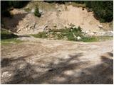
From the parking lot, we head onto the cart track which branches off to the left from the road. The cart track goes into the forest and ascends moderately, first crossing a smaller and then a larger stream. The cart track, which has some shortcuts, makes some turns and after a good 15 minutes brings us to the pastures of the mountain pasture Spodnja Dolga njiva.
After a short walk across the mountain pasture, the path brings us to a junction where there are signposts. We head right in the direction of the Košutnikov turn eastern approach path. The gentle path brings us, after a few dozen steps of walking, to the shepherd's hut on the mountain pasture Spodnja Dolga njiva.
Further ahead we continue upwards across the mountain pasture, in the middle of which runs a wide cart track that after a good 15 minutes of walking brings us out of the forest onto the mountain pasture Zgornja Dolga njiva.
The steepness of the path, which has been moderate until now, eases and the path soon brings us across nice grassy terrain to a junction. The signs for Košutnikov turn direct us left upwards along an initially barely visible path. When we approach the dwarf pines, we soon notice a nice wide path that turns to the left and crosses the southern slopes of Košuta in a gentle ascent. On this section of the path we carefully watch our step, as there are lots of snakes around here. The path then crosses a pasture fence and continues gently ascending for some time amid dwarf pines and sparse forest. This is followed by a slightly exposed crossing of the gully, after which the path starts to ascend more steeply across grassy slopes surrounded by sparse forest. During the ascent we can observe rocky pillars of the southern walls of Košuta on the right side. The path, ascending ever more steeply, then brings us to a side ridge of Košuta, which the path merely crosses before continuing into very steep slopes. The path crosses very steep slopes that are dangerous for slipping when wet, in a gentle ascent. After approximately ten minutes of walking, the steepness of the slopes eases and the path brings us to the next side ridge of Košuta. Here the path turns right steeply upwards and brings us to the border ridge. Here we notice a gully where the abandoned path from Austria joins.
The path here turns slightly left and then ascends alongside the gully upwards. The path, which remains fairly steep, then soon brings us across the summit grassy slopes to the panoramic summit.

Photos:
 1
1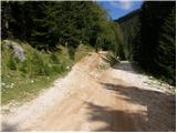 2
2 3
3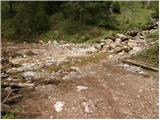 4
4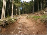 5
5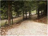 6
6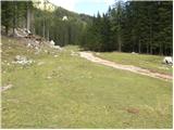 7
7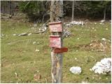 8
8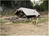 9
9 10
10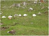 11
11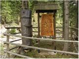 12
12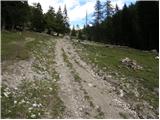 13
13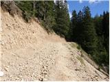 14
14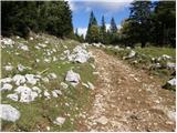 15
15 16
16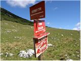 17
17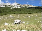 18
18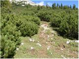 19
19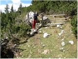 20
20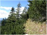 21
21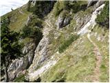 22
22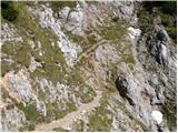 23
23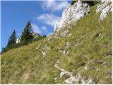 24
24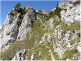 25
25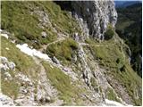 26
26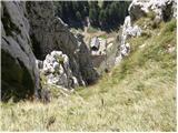 27
27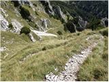 28
28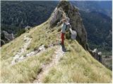 29
29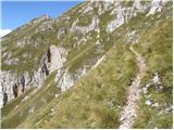 30
30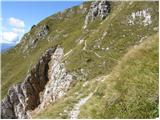 31
31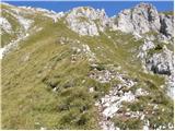 32
32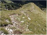 33
33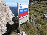 34
34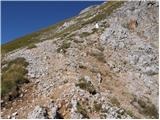 35
35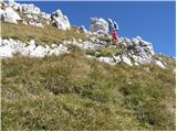 36
36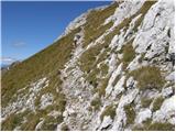 37
37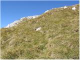 38
38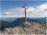 39
39
Discussion about the trip Pod Krnico - Koschutnikturm (Košutnikov turn) (eastern way)
|
| Gost6. 10. 2007 |
Does anyone know the condition of the road to the parking lot at the quarry?
Thanks and best regards, Ljubica
|
|
|
|
| Gost9. 10. 2007 |
The road is passable. Just today when I went to Košutnikov turn they were maintaining it. Good luck.
|
|
|
|
| lepenatka17. 06. 2009 |
Hi, on Sunday on the path from Dolga njiva, hopefully not earlier, I lost the threaded part that screws over the tip of the pole (Gabel pole). I've already searched in shops in our area, but found nothing. Can someone maybe advise where I can find such a "spare" part?
Thanks.
|
|
|
|
| lepenatka17. 06. 2009 |
Thank you very much for the information.
I wish you many more enjoyments in the mountains.
|
|
|
|
| Ajda_Zitnik28. 11. 2011 |
I hiked the path yesterday. The path was dry, I would just add that it is exposed and not suitable for those afraid of heights.
|
|
|
|
| 5Xum23. 09. 2012 |
Which variant is better, up the eastern and down the western or vice versa? I'd rather go up the slightly harder one, down the slightly easier...
|
|
|
|
| Janiel7423. 09. 2012 |
Yesterday did the loop...up the western, down the eastern...that's the better variant
|
|
|
|
| Lunca23. 09. 2012 |
The western one is, I think, a bit shorter, from the viewpoint that you start at the beginning of the pasture itself. A considerable part of the trail ascends in gullies, you see the summit when you're already well over halfway. It's a bit steeper and more demanding than the eastern one. The eastern starts from the upper part of the pasture, initially through meadow, then through scrub (a real hell in summer), then also on steep grass, the summit is in view most of the way... Personally, I prefer west up and east down. But it's a fact that both require a lot of caution, as Košuta offers magnificent cliffs alongside wonderful views..
|
|
|
|
| Jure7112. 07. 2013 |
At the beginning of the path when you turn left at the alpine pasture above Dolga Njiva the pines have already overgrown the path strongly, I had my right side completely soaked from dew on the needles. Otherwise, I recommend the path; it is very varied and scenic.
|
|
|
|
| navdušena2. 08. 2015 |
Has anyone been on this trail to Košutnikov turn this year? What's the trail like - road to the starting point?
|
|
|
|
| tinky2. 08. 2015 |
Check current conditions. The road is in fairly good condition.
|
|
|
|
| navdušena22. 08. 2016 |
What's the road to the starting point like this year? Is it only for high vehicles (SUVs) or possible also with a regular passenger car (Corsa)?
|
|
|
|
| Grenaleva22. 08. 2016 |
About a month ago the road was in good condition even for smaller vehicles, so reachable to starting point without issues.
|
|
|
|
| Deniss10. 09. 2016 |
On Zgornji Dolgi Njivi there is no signpost for the junction to the Turn, making it impossible to find the start of this eastern path, especially if someone is there for the first time and doesn't know where to even start looking. I had already reached the junction to Tolsta Košuta and, since I no longer knew where to go, returned to the hut and went up the western path and came back down this eastern one... and now I know where to go... Thanks to the person responsible for removing those markers, for my morning "frustration" and extra hour of walking... Thanks to the person responsible for removing those markers, for my morning "frustration" and extra hour of walking...
|
|
|
|
| slimat10. 09. 2016 |
I'm also looking now where and how, even though I'm from Tržič but haven't conquered the summit yet, so up the western and down the eastern will be OK?? Deniss thanks for the comment, now everything is clear to me
|
|
|
|
| koroški jože22. 10. 2017 |
DENISS already wrote on 10.9.2016 that there is no marking or signpost for the turn-off to the Turn. On the nice last sunny Saturday, my wife and I used it to conquer Košutnikov turn. But we ended up at Debelo Košuta. Really thanks PD Tržič, that we could see Košutnikov Turn from all sides, just not from the top.
|
|
|
|
| Lisica22. 10. 2017 |
 You'll have to get some map or phone app that has the paths drawn in. You'll have to get some map or phone app that has the paths drawn in.  Otherwise ask someone along the path. Otherwise ask someone along the path.
|
|
|
|
| Lunca23. 10. 2017 |
I already walk it from memory, but I remember that on a larger stone it said Kosutnikov turn with an arrow left. But is that no longer there?
|
|
|
|
| danielenidoma4. 11. 2017 |
At Planina dolga njiva there is a sign for Kt west and Kt east .. we went yesterday up and down the west one, but still missed that inscription on the stone near the top saying LEFT and went straight on the path and arrived at this west path .. Thanks to the friendly hiker who redirected us to the right path. The road to the starting point is without features, even a regular car can do it, not just an off-roader  good luck good luck
|
|
|
|
| Lunca25. 07. 2018 |
Today we returned on this path, it is not in the best condition.
|
|
|
|
| Zgembo1. 01. 2019 |
Nice tour, you can't reach the starting point by car, quite icy roads, and at one end the road is quite torn up. There was quite a bit of snow, winter gear recommended. Here are some photos
https://www.youtube.com/watch?v=YaskQ1FuglA
|
|
|
|
| Zdenkob6. 08. 2020 |
Last Saturday I set off on this hike. As Deniss wrote a few years ago, there is no signpost on Zgornja Dolga njiva for the turn-off towards Košutnikov turn, so I continued straight along the path. When I noticed I had missed it, I decided to go to Tolsta Košuta and it was fine, as I hadn't been there before. On the way back, I carefully looked where to go to the Turn and found the starting point. It is about 10 m behind large boulders at the beginning of Zgornja Dolga njiva, the sign and markers are on a rock about 10 m to the left of the path.
On the way home, I had some trouble driving from Jelen dol to Tržič, as the road was closed until 16:00 due to works (it was still open in the morning when I went there). Luckily, I met a friendly local at the parking lot who explained the detour to me. For those who might find themselves in a similar situation: in Medvode, turn left over the wooden bridge and then over the hills to Lom pod Storžičem. The road is of course gravel and quite narrow in places for passing, but drivable with some caution.
|
|
|
|
| trdi16. 11. 2020 |
A few years ago I went up and down the western trail, yesterday up the western and down the eastern for a change. I have to say, the eastern trail for descent is quite demanding, for almost a whole hour you need to watch every step, as the narrow trail runs mostly above drop-offs and any slip can be fatal, especially since the trail is full of scree or overgrown with grass. It's not secured anywhere. In short, I advise against it in the wet, and even otherwise for descent. If at all, then up this trail and western down.
|
|
|
|
| tango21. 11. 2021 14:31:48 |
Today up and down the eastern path, as there seemed to be quite some traffic on the western one from afar, the eastern was empty. Path ideal, nothing frozen, nothing muddy, only when we reached the ridge (from picture 34 onwards) it was blowing quite strongly, on the summit even more. At 10 we were alone on top, pure pleasure!
|
|
|
|
| ucakakla4. 09. 2023 09:22:14 |
I'm interested in the easiest path to visit both the summit of Košutnikov turn and Tolste Košute?
|
|
|
|
| plaNinaPirsMajcen26. 08. 2025 18:59:19 |
Hi, attaching a video of the eastern trail to Košutnikov turn.
https://youtu.be/V1EXps9EO90?si=hbA7uF1bhOG-dj5b
I enjoyed the solitude, I liked the narrow path across steep slopes, with views of jagged ridges towering above me. It's really steep only in the last part of the trail, to the eastern notch or state border.
The western trail, which I took back, I didn't like. Mostly tedious zig-zag all the way to planina Spodnja Dolga njiva.
The road to the starting point is not exactly for low cars.
I also visited the nearby Stegovnik waterfall, which impressed me with its pleasant energy.
Best, Nina
|
|
|
To post a comment you must log in:
If you do not yet have a username, you must first
register.