Podblica - Sveti Primož in Felicijan (Jamnik)
Starting point: Podblica (675 m)
| Latitude/Longitude: | 46,25670°N 14,20670°E |
| |
Walking time: 50 min
Difficulty: easy unmarked way
Elevation gain: 156 m
Elevation difference along the route: 180 m
Map: Škofjeloško in Cerkljansko hribovje 1:50.000
Recommended equipment (summer):
Recommended equipment (winter):
Views: 7.280
 | 1 person like this post |
Access to starting point:
A) We drive to Kranj, then follow the signs for Besnica (the turn-off from the old Ljubljana - Kranj road is before the bridge over the Sava River, or after the bridge if coming from the direction of Kranj). We continue driving through Spodnja and Zgornja Besnica and Njivica. A little further on, we arrive in Nemilje; after the mentioned settlement, the road starts to ascend more steeply. When we arrive in Podblica, we follow the main road, and when we notice the recycling spot on the right, that is where the described path begins. We do not park at the recycling spot, because that would block access for locals to the waste containers. We park at a suitable spot along the road lower or higher up.
B) From Železniki, we drive to Dražgoše, then continue driving towards Kropa. This is followed by a traverse across the slopes of Jelovica, then we arrive at a crossroads where the road to Kranj branches off sharply to the right (the turn-off for Kranj is only from the opposite direction). Here we continue sharply right (if the bend is too sharp, there is a designated turning area about 50 metres further on), then we descend to Podblica, where just before the centre of the settlement on the left we notice the recycling spot where the described path begins. We do not park at the recycling spot, because that would block access for locals to the waste containers. We park at a suitable spot along the road lower or higher up.
C) We drive to Kropa, then continue driving towards Dražgoše and Železniki. After the Jamnik settlement, we leave the road to Dražgoše and continue left towards Kranj. This is followed by a descent to the Podblica settlement, where the described path begins at the recycling spot. We do not park at the recycling spot, because that would block access for locals to the waste containers. We park at a suitable spot along the road lower or higher up.
Route description:
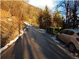
From the crossroads above the recycling spot we continue right in the direction of Jamnik and Peka piškotov Metka. The path first leads along a narrower asphalt road past a few houses. At the last house we turn right onto a cart track, along which we ascend mainly transversely. Higher up we reach a newer house, which we bypass on the upper side, then behind the yard we continue again on the cart track, which leads us past a shrine. A little further on we reach the main Dražgoše - Kropa road, which we follow to the right (straight ahead, or slightly left - Bela peč). With fine views we reach the village of Jamnik, where the road forks. We continue along the upper road above the village, or we can also take the lower one through the village. Both roads join after a few minutes, and we walk a few more minutes towards Kropa, then the signs for the church of St. Primož and Felicijan direct us right downhill. This is followed by a descent down steps, then we reach a scenic ridge along which we walk in a few minutes to the mentioned church, from which a fine view opens up.
Description and pictures refer to the situation in 2017 (December).

Photos:
 1
1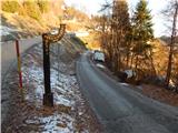 2
2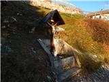 3
3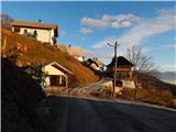 4
4 5
5 6
6 7
7 8
8 9
9 10
10 11
11 12
12 13
13 14
14 15
15 16
16 17
17 18
18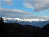 19
19 20
20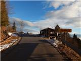 21
21 22
22 23
23 24
24 25
25 26
26 27
27 28
28 29
29 30
30 31
31 32
32 33
33 34
34 35
35 36
36 37
37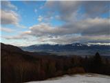 38
38
Discussion about the trip Podblica - Sveti Primož in Felicijan (Jamnik)
To post a comment you must log in:
If you do not yet have a username, you must first
register.