Podgorje - Slavnik (steep path)
Starting point: Podgorje (518 m)
| Latitude/Longitude: | 45,53132°N 13,94719°E |
| |
Route name: steep path
Walking time: 1 h 20 min
Difficulty: easy marked way
Elevation gain: 510 m
Elevation difference along the route: 510 m
Map: Slovenska Istra - Čičarija, Brkini in Kras 1:50.000
Recommended equipment (summer):
Recommended equipment (winter):
Views: 145.812
 | 5 people like this post |
Access to starting point:
A) From the highway Ljubljana - Koper we take the exit Kozina, and then on the old road towards Koper we drive to the settlement Petrinje (smaller settlement on the right side of the main road), where we turn left in the direction of Podgorje. The road, which at first steeply ascends, soon brings us to the next crossroad, where we continue left, again in the direction of Podgorje. We then drive ahead to the village Podgorje, where we park on a large parking lot near the sports field.
B) From the highway Koper - Ljubljana we take the exit Kastelec, and then we continue right in the direction of Ljubljana, Kozina and Podgorje. Two more crossroads follow, at both we go left or straight in the direction of Podgorje (at the first crossroad we also follow the signs for Kozina). We follow this road to the large parking lot near the sports field, which is situated in the village Podgorje.
Route description:
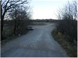
From the parking lot, we return to the main road which we follow ahead in the direction of driving. After a few dozen meters, we come to a crossroad, where wooden signposts point us to the left past the chapel upwards. We then follow the asphalt road to the next crossroad where there are a few benches. Here we continue left upwards and past houses we get to the beginning of the steep path on Slavnik. A wide path then soon goes into the forest, where it moderately and occasionally steeply ascends. A little higher, the path crosses a newly made wide cart track and then for some time still ascends through the forest on a well-marked path. After a good 45 minutes of walking from the parking lot, the path passes out of the forest on the more and more panoramic slopes. After additional 15 minutes of walking, we finally step out of the forest and in front of us, we notice a wide upper slope of Slavnik. The path ahead leads us past the sign, which informs us that we are entering the area of natural monument Slavnik. From here on we already clearly see the peak of Slavnik which we reach after a few minutes of easy walking.

Photos:
 1
1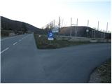 2
2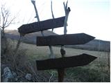 3
3 4
4 5
5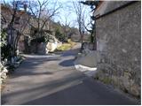 6
6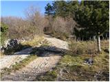 7
7 8
8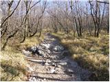 9
9 10
10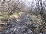 11
11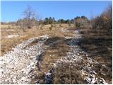 12
12 13
13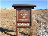 14
14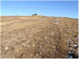 15
15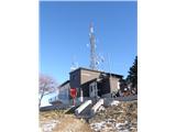 16
16 17
17
Discussion about the trip Podgorje - Slavnik (steep path)
|
| klavdy610. 01. 2009 |
demanding but with an extraordinary view
|
|
|
|
| NEIC00813. 03. 2009 |
12.3.2009-- not very strenuous path. At the top in less than an hour. Hut unfortunately closed, quite windy, but very nice view.
For those who need a stamp, bring your own ink pad, otherwise no stamp..
|
|
|
|
| novinsekp19. 02. 2010 |
Does anyone know if the hut on Slavnik is open on weekends at this time? Thanks.
|
|
|
|
| hisnik19. 02. 2010 |
In February still on weekends and from 01-03-2010 from Wednesday to Sunday.
|
|
|
|
| DADA19. 02. 2010 |
THERE IS CURRENTLY A LOT OF SNOW, IS IT ICY? WE WOULD RATHER GO ON SUNDAY VIA THE GENTLE PATH.THANKS.
|
|
|
|
| ajax20. 02. 2010 |
Yes, check the webcams to see if any snow is visible. Lp
|
|
|
|
| furioso22. 02. 2010 |
On Slavnik there is 20 cm of southern snow. It starts at approx. 850 m.a.s.l. It is well trodden so no problem.
@Ajax where are you hanging out, are you still alive? When are we going hiking somewhere?
|
|
|
|
| DADA22. 02. 2010 |
THANKS, MAYBE WE'LL SET OFF THIS WEEKEND.
|
|
|
|
| bojann23. 02. 2010 |
Maybe someone knows if the path from Prešnica is icy where the snow starts? Last time it was quite nasty.
|
|
|
|
| darh14. 04. 2010 |
On Easter Sunday we set off on the steep path to Slavnik. Except for remnants of snowdrifts among the last pines below the summit, there is no more snow. We returned to the valley via Grmada towards Prešnica and from there back to Podgorje. More about our impressions here.
|
|
|
|
| Majdag28. 04. 2011 |
I was up there, first time, with hiking friends. The view must really be wonderful in good weather. Unfortunately, yesterday it was all rather foggy. Not many primroses, narcissi and some peonies. Due to the gale, we soon headed down to the valley. Then we visited the Škocjan Caves. Two nice things in one day, ciao Majda...
|
|
|
|
| Kokta29. 10. 2011 |
Nice little path, the weather was wonderful, service and offer in the hut excellent. I recommend a visit in late autumn days as Slavnik is painted in wonderful colors..... view on the Gulf of Trieste is superb
|
|
|
|
| Karletto21. 11. 2011 |
Last time on the gentle trail I noticed a sign "Caution bear den ahead" or nearby, something like that. 
Is this a joke or are we serious??
|
|
|
|
| Karletto21. 11. 2011 |
*pardon, the mentioned sign is on the steep trail.
|
|
|
|
| žan12. 01. 2013 |
nice hike
|
|
|
|
| smatjaz16. 04. 2013 |
Great tour, otherwise the steeper variant is full of small paths and trails uphill. So whichever you choose you can't go wrong because they all lead to the same goal - Slavnik
|
|
|
|
| klavdy623. 06. 2013 |
Can the transversal stamp from the hut be obtained even if the hut is closed? Thanks for the reply.
|
|
|
|
| B223. 06. 2013 |
The original transversal stamp (new) and the commemorative stamp for the 60th anniversary of SPP mandatory control point Slavnik is available only in the hut. When the hut is closed, the summit stamp of Slavnik also counts.
|
|
|
|
| 4polon15. 02. 2014 |
Today I was on Slavnik for the first time. Nice hike. At the top it was blowing very strongly and there was unfortunately very dense fog, so I had no views..
The sign that informs us we are entering the area of the natural monument Slavnik (picture no. 14) is no longer there or is on the ground a few meters aside, damaged.
|
|
|
|
| zabava8. 10. 2014 |
This is the third time I've been to Slavnik. I knew the hut was closed on Monday 29.9., but I just needed the stamp and a nice view. You can see the hut from afar, so hikers and mountaineers coming down from the hut. Just before the hut a dog rushed at me and my daughter. It was barking and showing teeth, we both stopped and waited for the owner to at least grab it by the collar. But no! According to her, we were to blame because we HAD TREKKING POLES!!!. Since she wouldn't grab it by the collar at all, let alone leash it, and with her repeated claim that the dog barks because we have poles, the barking was terrible, but we stayed calm, I told her I'd still like to reach the top, she finally moved the dog so my daughter and I could at least "stamp" our logbooks and change behind the hut corner and go down. Such rudeness! Dogs must be on a leash. But apparently the "lady" doesn't know that. Bad experience, but Slavnik is still nice. PD, please inquire and urge, hikes to mountains and hills are for everyone, but dogs should be on a leash!
|
|
|
|
| valerija1128. 10. 2014 |
Entertainment, I agree with you. We have a dog at home, we walk it on solitary hayfields around the village, on crowded paths it's leashed. To the mountains we go without it. Dogs off leash disturb me a lot, I'm also afraid of them. It's all in the owners' heads. Nice regards and happy trails.
|
|
|
|
| maboze1x4. 03. 2015 |
This is supposed to be a very well-marked trail?
|
|
|
|
| valerija1124. 03. 2015 |
This is a nicely marked trail. Nice trip up the steep one, back on the gentle one.
|
|
|
|
| nipecar4. 03. 2015 |
What trees are along the path to Slavnik?
|
|
|
|
| slavkoo5. 03. 2015 |
I've been to Slavnik many times, always starting from Podgorje. For the start of this season I chose Slavnik again, but from a different starting point. Who knows... is the path from Prešnica or perhaps from Skadanščina more interesting and frequented?
|
|
|
|
| opica10. 03. 2015 |
I really like eating Kinder eggs and I'm wondering about the following. What packaging should I wrap my Kinder egg in so that it stays in its original shape on the way to the top? Is aluminum foil, cellophane suitable? I've heard namely that cellophane is only suitable for wrapping flowers or candles. Does that hold true too?
|
|
|
|
| Smetar10. 03. 2015 |
hahaha @opica: I suggest you put them in the freezer this evening and then in the morning in plastic packaging and take them to Slavnik
@Slavkoo: you should ask OPD maybe they keep statistics on where more hikers start
|
|
|
|
| Clovek121. 09. 2015 |
I hiked this trail yesterday in 40 min. If I lead a group of people who don't hike, will we really need 1h15?
|
|
|
|
| Smetar21. 09. 2015 |
depends on their fitness. If they have average fitness, they will generally need 1h to 1h15. Depends on the sport they do or their physical condition.
Better to say 1h15 hiking, if less they will be happier
|
|
|
|
| modrook1216. 01. 2016 |
I'm wondering how long it takes to Socerb? thanks for the answer and LP
|
|
|
|
| spela marela15. 03. 2016 |
Hello, I'm wondering if the summit/path is still snowy or what the current conditions are?
thanks for the reply
|
|
|
|
| B215. 03. 2016 |
Just good will and (dry) path under your feet!
|
|
|
|
| spela marela16. 03. 2016 |
B2 thanks for the reply. Planning with kids on Saturday, weather will be good, but don't want full scrambling, as I already struggle to get them ready for hiking
|
|
|
|
| Badi16. 02. 2017 |
Does anyone have information about the path? Is it still snowy?
|
|
|
|
| B218. 02. 2017 |
@Badi, cheerfully on the path. Since no one answers you, I'll do it. No snow or ice in this part of Primorska for a long time. Have a nice day on the ascent to Slavnik!
|
|
|
|
| modrook1216. 04. 2017 |
and who knows if the hut is open tomorrow? I'm asking about the stamp, can it be obtained?
|
|
|
|
| modrook1217. 04. 2017 |
today we went on this trail to Slavnik. back on the gentle one. nice trip. many trails can be seen leading to the top
|
|
|
|
| fpetel119. 04. 2017 |
At the beginning of April I went up from Prešnica and down the steep one towards Podgorje. You add a few kilometers to return via the fire trail and gravel along the railway back to Prešnica.
Nice circular trail for us who don't go to the top every day.
|
|
|
|
| claire3. 05. 2017 |
I walked the path in 1 hour - it didn't seem steep to me, but I don't know what the gentler variant is like.
I would praise the excellent path marking. Given that it's quite a rocky path, I recommend sturdy boots.
Stamps are available in the hut - I didn't notice them outside.
On weekends and holidays parking is paid - 2€ for the whole day.
|
|
|
|
| modrook124. 05. 2017 |
I was surprised that the parking lot is paid. Although 2 euros is no problem for me. The gentle variant is nothing special, the steep path is more interesting to me.
|
|
|
|
| saqo7. 09. 2020 |
A while ago I was there. Since the path was very muddy, I wasn't paying attention to whether there were markers or not. Since the path seemed quite steep to me, but here it says it's not that bad, I'm wondering if I didn't go off the path. So I ask you: when you come out of the forest onto a gravel road, do you go straight into the forest "off the road" or somewhere else? Thanks
|
|
|
|
| golica2. 03. 2023 18:36:42 |
Has anyone hiked to Slavnik yesterday or today, how much snow is there? I read a notice from some PD that there's 15 cm of snow up there, but I'm not entirely sure if it's accurate info. Thanks
|
|
|
|
| B22. 03. 2023 21:52:18 |
From the southern side there's none. From Skadanščina just enough to say we walked on snow. Otherwise why are you asking, maybe just for information or after a long time?
|
|
|
|
| golica6. 05. 2024 08:49:48 |
How is it with the flowers on the Slavnik ridge, are various primroses blooming yet, or is it still too early. Thanks
|
|
|
|
| Janez Seliškar6. 05. 2024 11:32:33 |
Currently, there are the most daffodils.
|
|
|
|
| franca7. 05. 2024 13:43:26 |
Along the paths from Skadanščina and from Malih vrat, peonies are blooming
|
|
|
|
| benjaming12. 04. 2025 20:00:02 |
The path is rocky, view from the top nice, hut tidy and food good. All in all a nice trip
Stamps are available outside too, but I found the oval ones for Slov. alpine trail only in the hut.
|
|
|
To post a comment you must log in:
If you do not yet have a username, you must first
register.