Podljubelj (Lajb) - Zajmenove peči
Starting point: Podljubelj (Lajb) (770 m)
| Latitude/Longitude: | 46,41510°N 14,27010°E |
| |
Walking time: 2 h 50 min
Difficulty: difficult pathless terrain
Elevation gain: 975 m
Elevation difference along the route: 975 m
Map: Karavanke - osrednji del 1:50.000
Recommended equipment (summer):
Recommended equipment (winter): ice axe, crampons
Views: 3.320
 | 2 people like this post |
Access to starting point:
We leave the Gorenjska motorway at the Podtabor junction, and then continue driving towards the Ljubelj border crossing. Further on, we drive past the turn-off for Bistrica pri Tržiču, and higher up also past the turn-off for Podljubelj. A little after the 4.5 km road sign, after the underpass we turn right and then once again right into Podljubelj. We park at a suitable place by the sign which marks the beginning of Podljubelj.
Route description:
From the starting point, we continue on the local road which leads towards the centre of Podljubelj, and we follow it to the hamlet Črni Gozd, arriving at the hamlet after a good 5 minutes of easy walking on the asphalt road.
At the mentioned hamlet we continue left onto a poorer forest road which splits into two cart tracks at the edge of the forest. We continue on the left cart track which further leads along the edge of a meadow, and at the next junction we go straight ahead (the right cart track bypasses Rjavka 998 m on the south side and it is also possible to reach Zajmenove peči along it). The cart track splits once again a little further on, and this time we continue right, gradually entering the valley north of Rjavka. This is followed by an ascent along the cart track, which ascends quite steeply through the forest; higher up it temporarily splits into a less steep left track and a steeper right one. Higher up the tracks merge, then at a smaller junction we continue on the wider right cart track, which leads us from the valley onto the slope. A traverse ascent towards the right follows, along which the path takes us over the ridge northeast of Rjavka. The cart track makes a left serpentine a little further on, followed by a few smaller junctions where we follow the wider cart track. Higher up we reach an indistinct southern lateral ridge which descends from Zajmenove peči towards the valley. At that point the cart track ends, and we continue some ten steps across to the right, where a poorer path appears on the indistinct ridge (here we join the path from other starting points). We continue the ascent along the poorer path, which vanishes here and there completely, and beside which we notice a few cairns. All the time we ascend steeply in approximately the same direction; the ridge becomes ever less distinct and the slope ever steeper. Higher up the occasional path almost vanishes completely, and individual cairns direct us a few steps to the left, where we reach a kind of grassy gully along which we continue the ascent. The grassy slope is interrupted by occasional belts of sparse forest or dwarf pines, and the direction of ascent remains the same, i.e. straight upwards. We bypass shorter rocky cliffs on the left side and through steep grass and dwarf pines reach the ridge of Zajmenove peči, from where a fine view opens up. If we have reached the ridge left of the summit, we continue right and with fine views reach the bench and a few steps further the summit of Zajmenove peči.
The description and pictures refer to the situation in 2018 (September).

Photos:
 1
1 2
2 3
3 4
4 5
5 6
6 7
7 8
8 9
9 10
10 11
11 12
12 13
13 14
14 15
15 16
16 17
17 18
18 19
19 20
20 21
21 22
22 23
23 24
24 25
25 26
26 27
27 28
28 29
29 30
30 31
31 32
32 33
33 34
34 35
35 36
36 37
37 38
38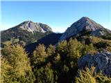 39
39
Discussion about the trip Podljubelj (Lajb) - Zajmenove peči
To post a comment you must log in:
If you do not yet have a username, you must first
register.