Poljana (Završnica) - Mali vrh above Završnica
Starting point: Poljana (Završnica) (640 m)
| Latitude/Longitude: | 46,40720°N 14,14610°E |
| |
Walking time: 35 min
Difficulty: easy marked way
Elevation gain: 223 m
Elevation difference along the route: 223 m
Map: Karavanke - osrednji del 1 : 50.000
Recommended equipment (summer):
Recommended equipment (winter): ice axe, crampons
Views: 8.450
 | 3 people like this post |
Access to starting point:
From the highway Ljubljana - Jesenice we take the exit Lesce, then at the roundabout onto the old road towards Vrba, Žirovnica and Jesenice. After a few km of driving, we drive straight through the crossroad where roads branch off towards Moste and Žirovnica. When we then drive past the viaduct Završnica, we come to the right turn-off, where we turn (sharply right). After some tens of meters at the smaller crossroad we turn left, in the next (after 50 m) right, in the direction of Završnica. After a short descent, the road ascends a little and soon brings us to the spot where a macadam road branches off to the left towards Valvasorjev dom. We park on the new parking lot nearby, which is situated next to the accumulation lake on the right side of the road.
Route description:
From the parking lot we head over the bridge on the dam of the accumulation lake, and on the other side turn left. We walk on the wide path which first leads along the lake and then further along the slope on the right, straight towards the meadow. At the end of the latter, where nearby we spot a bridge over the stream and a neat building on the other side, we notice a wooden signpost with the inscription Mali vrh, located on the right. Here we turn onto the path that takes us to the northern slope of the ridge Reber (Brezniške peči). After a short initial ascent at the small junction we continue right (sign) towards the top of the slope. The path in zigzags ascends moderately at first, when a little higher it brings us below the rocky cliffs which it bypasses on the left, then the slope and with it the path become steeper. In a few further zigzags we ascend to the ridge, where there is a junction with a sign Mali vrh. Here we turn right (left Peči, Gosjak, Smokuški vrh) and on a rocky path ascend to the summit of Mali vrh, which we reach in a few steps. We continue for a short time along the ridge towards the west, where the path descends a little, soon after on the cleared part of the ridge we already see benches with a table located under a wooden shelter. On the pillar of the latter is attached a box with the registration book.

Photos:
 1
1 2
2 3
3 4
4 5
5 6
6 7
7 8
8 9
9 10
10 11
11 12
12 13
13 14
14 15
15 16
16 17
17 18
18 19
19 20
20 21
21 22
22 23
23 24
24 25
25 26
26 27
27 28
28 29
29 30
30 31
31 32
32 33
33 34
34 35
35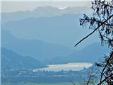 36
36
Discussion about the trip Poljana (Završnica) - Mali vrh above Završnica
|
| heinz6. 05. 2016 |
Judging by your last "Google earth" picture, it seems you went via the other (traverse) one. The one described above is the one opposite the Zavrh snack bar, directly "v iber" onto the ridge, then right to M.v. Regards, H!
|
|
|
|
| Majdag7. 05. 2016 |
... Heinz, judging from the photos and description, your approach is from the other direction. I think there's nothing wrong, there are two paths almost from the same starting point: yours direct and mine easier traverse. I'll add to the blog that this is the other path, thanks.
|
|
|
|
| heinz7. 05. 2016 |
Majda, this one is also (technically) easy, just steeper, but still interesting. Chamois can also be spotted.
|
|
|
|
| Majdag8. 05. 2016 |
... I'll soon go via your variant, I like such little paths.
|
|
|
|
| marezt9. 05. 2016 |
I can still eat
For me the most enjoyable path is from Selo pri Žirovnici past Sv. Lovrenc
|
|
|
|
| Majdag15. 06. 2016 |
Mali vrh..
...And we went for it, following the route description. The path is nice but very short and we continued along the ridge and descended near Titova vas.
|
|
|
|
| JusAvgustin2. 02. 2019 |
Another option is right after gostišče Zavrh left over the bridge and immediately along the hunting trail that climbs in zigzags to the saddle left of Mali vrh. It is much faster than the trail from the pasture but correspondingly steeper. The trail is well traceable when dry. Safe travels on your paths.
|
|
|
|
| jurijt7. 01. 2020 |
Short path, but views towards Bled, Julian Alps, Karavanke and Jesenice are stunning.
The path is suitable for dogs, but barely. On the ridge it's very steep and a more playful dog can quickly roll down. We were with two and didn't continue to the end because they had too much energy.
|
|
|
|
| Rokovnjacica9. 01. 2020 |
Hello everyone
I've been observing this Mali vrh from the road on the way to the upper Sava valley for some time.
Majdag, could you advise me, please, which path would be most suitable to Mali vrh so that the dog can come too, given that I read in the comment of "jurija t" that this path is barely suitable for dogs... as you also carried your Bučka a bit in between
(and to find Titovo vas too)
|
|
|
|
| Majdag9. 01. 2020 |
Rokovnjacica, it depends how big the dog is. My Ira (10 kg) I pushed over the rocks ahead or carried her over. She couldn't manage the rocks alone. But once I met a 16-year-old golden retriever. The owner said he walks the entire ridge every year. Otherwise our Marjana, when she was wandering with the retriever, couldn't go with him along the ridge. For larger breeds the rocks are quite a problem if the dog isn't used to such terrain. At Gosjak and a bit further there are quite a few rocks. Check my latest blog. If you manage to reach the water reservoir, there is a marked path to Titovo vas. https://jelenkamenmajdag.blogspot.com/2019/11/reber-in-meli-nad-jalnovo-domacijo.html
To Mali vrh for me and also for larger dogs the nice path is towards gostišče Zavrh. There are just a few rocks and a little path beside. If it doesn't go further along the ridge, there is the option of ascent and descent on the same path. And continue along the forest trail as long as possible and then along the road, past Žingarica, to the turnoff for Titovo vas. I assume you walk a lot, maybe it will work. Good luck!
|
|
|
|
| Rokovnjacica10. 01. 2020 |
Thank you Majda
How good, you know, I have a golden retriever
Nice to read your blogs. I've decided we'll go straight along the path towards gostišče Zavrh as you advised.
Best regards
|
|
|
|
| Majdag10. 01. 2020 |
Enjoy your paths, it's nice to have a furry Bučka beside..
|
|
|
|
| Majdag17. 01. 2022 10:48:36 |
Mali vrh.. The path opposite Gostišče Zavrh is narrow, steep, icy. And wet snow, high annoying snowballs form. Difficult for descent. The signpost is only in the forest above the newly built road. The path with the signpost for Mali vrh, which is visible already on the meadow, is wide, gradually ascends and without major difficulties you quickly reach the ridge.
https://jelenkamenmajdag.blogspot.com/2022/01/mali-vrh-nad-zavrsnico.html
|
|
|
To post a comment you must log in:
If you do not yet have a username, you must first
register.