Pravdan - Vrtače (via Zgornje Palovče)
Starting point: Pravdan (356 m)
| Latitude/Longitude: | 46,18940°N 14,62400°E |
| |
Route name: via Zgornje Palovče
Walking time: 1 h 45 min
Difficulty: easy unmarked way
Elevation gain: 402 m
Elevation difference along the route: 425 m
Map:
Recommended equipment (summer):
Recommended equipment (winter): crampons
Views: 885
 | 1 person like this post |
Access to starting point:
A) From the roundabout on the Kamnik bypass, we take the exit in the direction of Volčji Potok, and then still before Arboretum Volčji Potok we turn left onto the road in the direction of Rudnik pri Radomljah. Further on, we drive past the golf course Arboretum, and when we reach the priority road in Rudnik pri Radomljah, from the intersection we continue right. The road leads us also past Glamping OB ROBU GOZDA and Galerija Repanšek, and then we arrive at the municipal border between the municipalities of Kamnik and Domžale. Here we park in a suitable place by the road.
B) We drive to Radomlje, where from the roundabout in the middle of the settlement we take the exit towards the settlement Rova. Some 100 m further from the church in Radomlje, we turn left onto Opekarniška ulica. Further on, we drive straight and follow the signs for Rudnik, and we park at the municipal border between the municipalities of Domžale and Kamnik.
Route description:
From the starting point, where we notice the first blazes, we continue on a cart track which branches off from the road towards the northeast. For some time we ascend gently to moderately through the forest, then the path passes onto an indistinct forested ridge, along and beside which we continue for some time. Higher up, the path turns right from the ridge and ascends diagonally to a junction before the tourist farm Čeh.
From the junction we continue left in the direction of Trebelno pri Palovčah, and continue the path along a slightly ascending macadam road.
On the slopes of Grdavov hrib we go right and continue further along the road. We walk along the road for quite some time, or until the point where a cart track branches off to the left from an indistinct small valley, along which we continue the ascent (we can also continue along the road, but it soon ends and then we have to ascend to the settlement Trebelno pri Palovčah across fields). We continue along a distinct track, along which we walk until we reach the asphalt road.
Along the asphalt road we continue right, along which we soon arrive at an intersection where the road from the settlement Trebelno pri Palovčah joins us. We continue along the main road, which past the chapel brings us to the village Zgornje Palovče. Through the village we ascend to a wooden cross, at which we turn sharply left onto a fairly steep road, along which we go past a few more houses; behind the houses we continue along a cart track, along which we ascend to a smaller saddle, where we go right onto a beaten path that ascends to the hunting observatory with fine views of the Kamniško Savinjske Alpe. At the hunting observatory the path goes slightly left and a little higher enters the forest, through which we continue to an indistinct summit.
Starting point - Čeh 0:30, Čeh - Zgornje Palovče 0:55, Zgornje Palovče - Vrtače 0:20.
Description and pictures refer to the condition in the year 2018 (December).

Along the route: Čeh (481m), Zgornje Palovče (657m)
Photos:
 1
1 2
2 3
3 4
4 5
5 6
6 7
7 8
8 9
9 10
10 11
11 12
12 13
13 14
14 15
15 16
16 17
17 18
18 19
19 20
20 21
21 22
22 23
23 24
24 25
25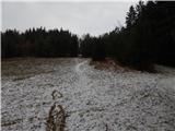 26
26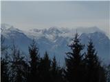 27
27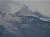 28
28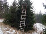 29
29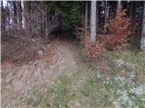 30
30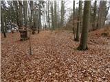 31
31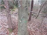 32
32 33
33
Discussion about the trip Pravdan - Vrtače (via Zgornje Palovče)
To post a comment you must log in:
If you do not yet have a username, you must first
register.