Prelaz Vrhe - Donačka gora
Starting point: Prelaz Vrhe (426 m)
| Latitude/Longitude: | 46,25830°N 15,75860°E |
| |
Walking time: 1 h 35 min
Difficulty: difficult marked way
Elevation gain: 458 m
Elevation difference along the route: 495 m
Map: Rogaška Slatina z Bočem in Donačko goro 1:25.000
Recommended equipment (summer): helmet
Recommended equipment (winter): helmet, ice axe, crampons
Views: 39.250
 | 4 people like this post |
Access to starting point:
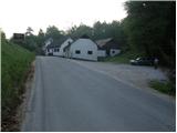
From the Ljubljana–Maribor motorway, take the Dramlje exit and follow the road ahead in the direction of Šentjur, Rogaška Slatina and Rogatec. In Rogatec, signs for Donačka gora direct us left onto a somewhat narrower road, which we then follow towards the village of Žetale. On a smaller pass, right at the spot where the municipality of Rogatec ends, we will notice a somewhat larger parking lot on the right side, where we park.
Route description:
From the parking lot, we first walk to the pass, where we continue on the left ascending road in the direction of Donačka gora. After a short ascent, only a few meters behind the house with thatched roof, signs for Donačka gora direct us right onto a gently sloping cart track, which after a few steps enters a short stretch of forest.
The cart track quickly emerges from the forest and continues across panoramic grassy meadows. Higher up, the path takes us to a lonely homestead, past which the marked path leads. Just a little above the mentioned homestead, we join a somewhat wider cart track, which we follow to the right (left Sveti Jurij and Sveti Donat). The cart track, which ascends diagonally farther on, mostly through forest, takes us to the next junction, where we continue left in the direction of Donačka gora (right Žetale).
After a short ascent along an excellently made path, the path from Rudijev dom joins from the right. Here we continue straight in the direction of Donačka gora along the path, which then ascends quite steeply. When the steepness eases, a traverse of steep slopes follows. The path ahead then takes us below the steep summit slope of the eastern peak of Donačka gora. A very steep ascent follows on a well-secured path to the ridge. Here, 20 m left from the path is the eastern peak of Donačka gora (marked, last meters secured with pegs).
We continue right on the path, which first descends slightly, then ascends along the ridge of Donačka gora. After approximately 20 minutes of walking along the steep vegetated ridge, we reach the western peak, where there is also the summit logbook.

Photos:
 1
1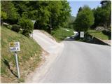 2
2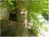 3
3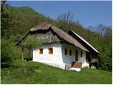 4
4 5
5 6
6 7
7 8
8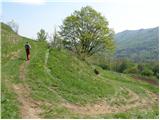 9
9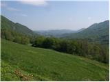 10
10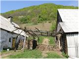 11
11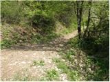 12
12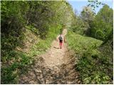 13
13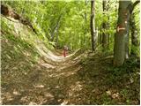 14
14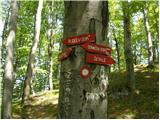 15
15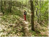 16
16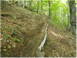 17
17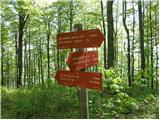 18
18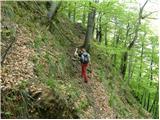 19
19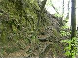 20
20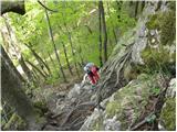 21
21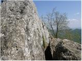 22
22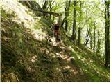 23
23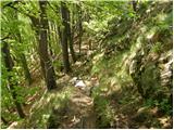 24
24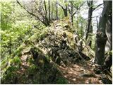 25
25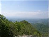 26
26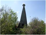 27
27
Discussion about the trip Prelaz Vrhe - Donačka gora
|
| petruša1. 03. 2010 |
I'm wondering what the conditions are like on Donačka gora. Is there still any snow left?
|
|
|
|
| šerpa1. 03. 2010 |
This is how "stankoju" described the situation on the forum two days ago:
"When I got home from work in the afternoon, the nice weather tempted me and I went on a circular route around Donačka gora and to the summit via the screes. The path on the southern side is mostly dry and not too muddy, on the northern side and towards Rudijev dom there is 10 to 15cm of packed snow on the path, which requires acrobatic skills so you don't slip; caution is still needed."
lp
|
|
|
|
| mojcej'7227. 04. 2010 |
Today, on 27.4.2010, Donačka gora was occupied like Ljubljana's Šmarna gora, obviously the nice weather and day off work attracted people. The walking time from the hamlet Tlake increases by another 1 hour, and if you're with a child 7 to 10 years old, another 30 minutes.
Further on the trail itself from Rudi's hut to the top, the path is even more interesting, from huge fallen trees to some squirrel, description of primeval forest and interesting rock layers. At the top, even the RS flag!
|
|
|
|
| Benjamin98320. 03. 2014 |
Can anyone tell me if there is a stamp on Donačka?
|
|
|
|
| pohodnik3820. 03. 2014 |
There is on both peaks....on the eastern one it's "a little" hidden under a rock.
|
|
|
|
| balon20. 06. 2014 |
I'm wondering if part of this ascent (the pegs) would be suitable for a 5-year-old? I must say she doesn't lack stamina, more for safety reasons.
Thanks for the answer.
Balončki
|
|
|
|
| garmont20. 06. 2014 |
The section with the via ferrata cable is not exposed. Just pay a little attention to where the child steps, and it'll be fine. Go bravely.
|
|
|
|
| Stamp3. 04. 2022 11:38:45 |
From the north, from Kupčinji Vrh direction, not a single direction is described.. We climbed one trail, descended another..
Easy (except that little rope), short and sweet.. At Rudi's Dom nice Grah and Ričet, and Bučnica.
Path description, map and photos at
THIS LINK
|
|
|
To post a comment you must log in:
If you do not yet have a username, you must first
register.