Starting point: Preserje (400 m)
| Latitude/Longitude: | 45,96130°N 14,42050°E |
| |
Walking time: 2 h 20 min
Difficulty: easy marked way
Elevation gain: 707 m
Elevation difference along the route: 740 m
Map: Ljubljana - okolica 1:50.000
Recommended equipment (summer):
Recommended equipment (winter):
Views: 32.230
 | 4 people like this post |
Access to starting point:
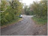
We drive to Podpeč and from there follow the road towards Krim. Soon a steep road branches off to the left towards Rakitna. We head onto it and follow it further to an intersection, where we turn sharply left in the direction of Sveta Ana. The narrow road soon brings us to an intersection, where we turn left towards the marked parking lot.
Route description:
From the parking lot, we return a few meters back in the direction of travel to the asphalt road, where we head upwards in the direction of Krim. The road then brings us to an intersection after a few meters, where we continue right on the lower road. After a further 100m of walking we leave the road and head onto the cart track in the direction of Krim. Further we follow the cart track, which ascends only gently through the forest. After approximately half an hour of walking the path crosses a panoramic meadow and then brings us to a junction, where the first path from the village Jezero joins us. The path a little further brings us to a smaller hamlet, where we continue right towards the church of St. Tomaž, which we see in front of us (left Jezero and Ledenica pri Planinci). The path ahead still ascends gently on the cart track, which has quite a few junctions, so we carefully follow the blazes. Somewhat higher the cart track crosses a forest road and starts to ascend more steeply. Further the steepness eases again and the path brings us to a wider cart track, where we join the path from the villages Tomišelj, Vrbljene and Strahomer. The wide cart track, which occasionally ascends somewhat more steeply, we follow all the way to the road on Krim.
Here we continue left and follow the road to the large parking lot. We continue right past a cross and on the meadow, which ends with stairs, we ascend to the mountain hut Dom na Krimu.

Along the route: Sveti Tomaž (572m)
Photos:
 1
1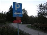 2
2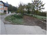 3
3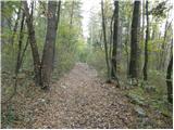 4
4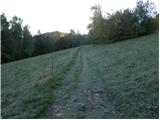 5
5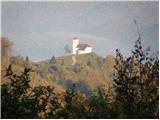 6
6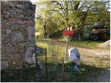 7
7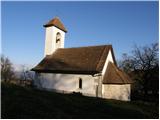 8
8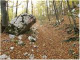 9
9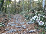 10
10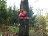 11
11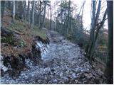 12
12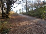 13
13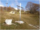 14
14 15
15
Discussion about the trip Preserje - Krim
|
| lepenatka18. 06. 2010 |
Tomorrow everyone to Krim - Exactly a tour of seven for Zlatorog's transferzalo of pride.
It'll be super.
|
|
|
|
| ciklama5. 03. 2011 |
Today my husband and I went on this path to Krim. Paths really cross constantly, so you have to watch the right direction, especially if you're going for the first time. At the top there was fog and everything covered in rime. In winter time it's an excellent trip, and we'll go up there again!
|
|
|
|
| burgy2630. 11. 2013 |
One thing interests me... is it possible to encounter bears on the trail?
|
|
|
|
| Okmodko30. 11. 2013 |
Now it's hard because they are in hibernation. Otherwise, you can encounter them quite often, but it's hard because the bear prefers to withdraw if it hears you. They are friendly though, so you don't have to be afraid of them. Just don't bring a dog, so it doesn't start barking at the bear, which would understand that it wants something bad from it.
|
|
|
|
| julius30. 11. 2013 |
@Okmodko
Bears haven't gone into winter hibernation yet. Besides, we humans stink to them and that's why they avoid paths where we move. But there live 1000X more dangerous critters than a bear in all its size. Well, these critters are plentiful all over Slovenia. So go calmly and without worry to Krim.
|
|
|
|
| Okmodko30. 11. 2013 |
Nowadays people are still taught in their profession by other people. You're right julius, on average brown bears go to sleep on December 3rd. Since every bear carries a calendar with it, there are probably still plenty of them. So I recommend you burgy26 to wait until Wednesday if you're afraid of bears. On Tuesday they all go completely to sleep, and you can calmly walk wherever you want the next day.
|
|
|
|
| Okmodko30. 11. 2013 |
No one has ever told me that I stink 
|
|
|
|
| CarpeDiem2471. 12. 2013 |
The 1000x more dangerous critters are surely ticks meant?
|
|
|
|
| julius1. 12. 2013 |
@Okmodko
Forget the average and December 3rd. When bears go into well-deserved rest depends on many things. Since you say you're a bearologist by profession, tell me why we see them even in January if the winter is mild.
If the statement that we stink is offensive to you, let's replace it with the claim that like all living beings, humans also emit certain odors. These odors trigger innate and learned alarm signals in most animals, followed by flight. Likewise, you won't encounter wildlife on very frequented paths. Of course there are exceptions, chamois, "Milka chocolate wrappers in certain areas of Austria and mountain jackdaws that have found the easiest way to forage for food.
@burgy26
And don't be afraid of bears. In Slovenia, bears have attacked only a couple of "heroes" who literally sought what they got.
@CarpeDiem247
You're right, meningitis, borreliosis and all the nice things associated with it.
|
|
|
|
| Okmodko1. 12. 2013 |
Of course, those who have bears across are bearologists. In January you meet them because bears don't have real winter sleep but doze as it's called. In winter they leave the den more often. And believe me, you know all this well. You're just trying to show off your knowledge about these animals in front of others, your nature can't easily accept that there are other people who know about it. Otherwise it's 7th grade elementary school material. Even though we have the same opinion on this, your nature tells you to show off, right?
Given that you talk so much about dangerous ticks... What would you say if I started showing off that ticks are already sleeping? Because now you'll have a much harder time finding that than a bear? Would you like that showing off?
|
|
|
|
| Mikens23. 06. 2019 |
IMPORTANT!
I ask all hikers to keep their dogs on a leash! (bear area.)
Best hunting regards.
Klement Mal, LD Tomišelj
|
|
|
|
| maya9915. 07. 2019 |
Hello! Yesterday I went to Krim from Iška for the first time. Now I plan to take the child too, and I'm wondering where there are more bears, lower down or in the last part of the trail. I'm considering leaving the car in Zgornji Ig instead, if there's more chance of encountering one lower down. thanks and best regards
|
|
|
|
| maya9915. 07. 2019 |
Yes, I just saw it right after I asked here. I live opposite Krim and it took me several years to gather courage. I'd rather take the kids elsewhere and go to the hills in Gorenjska. I'm really scared, as there was a cub in our settlement years ago, and a month ago a bear went through the gardens. I'm even scared of Ahac, even though it's so nice after work.
|
|
|
|
| exwannabe15. 07. 2019 |
I encountered the female bear twice. Whether it was the same one or not, I don't know. The last time was last week.
|
|
|
|
| ločanka15. 07. 2019 |
and didn't you ask her for her papers
|
|
|
|
| bongo15. 07. 2019 |
maya99, if you're scared, why do you have to go to Krim specifically, and with kids too? There's nothing wrong with fear, to avoid misunderstanding, previous posters have written a lot of useful things about bears years ago. But a bear is a beast, its behavior in each individual situation is hard to predict. In most cases, it will hear and smell you and withdraw, so you won't even notice its presence. But what if it doesn't? A scared mom with two kids in the middle of the forest or path against a 200+ kg female bear with cubs (especially if someone else has irritated it before)?
In your place, I'd go up with some company, maybe taste it in parts (drive higher by car and then walk along the main road), or simply wait. Krim isn't going anywhere, especially since there are nearby e.g. Polhograjske Dolomiti, maybe some peak towards Idrija, Novo Mesto etc. There are many hills with similar elevation and trail... If it comforts you, I've been looking at it for 20+ years but there was always something else more interesting. In the end, I went up only for the stamp and once for good company, after all, it's not a peak without which one can't live.
Good luck
|
|
|
|
| exwannabe16. 07. 2019 |
maya99 maybe you go with the kids on Sunday morning to Krim. Usually there are a lot of people then and "buzz" and practically no chance of encountering any animal...
|
|
|
To post a comment you must log in:
If you do not yet have a username, you must first
register.